Holding Breath
Every year, the insurance industry holds its collective breath regarding the dreaded “I” storm. The “I” storm is the most retired letter out of all hurricane names, but there is good news for the insurance industry this year. Tropical Storm Isaac formed in the central Atlantic late yesterday and is now the ninth named storm of the 2024 Atlantic hurricane season to date. On average, the ninth named storm forms on September 16th. Isaac is expected to move eastward and strengthen into a hurricane, but this year’s “I” storm is not anticipated to pose a significant concern for the insurance industry. However, the industry remains on edge, closely monitoring Hurricane Helene, which is forecasted to make landfall tonight around 8 p.m. local time.
Hurricane Helene Nearing Landfall
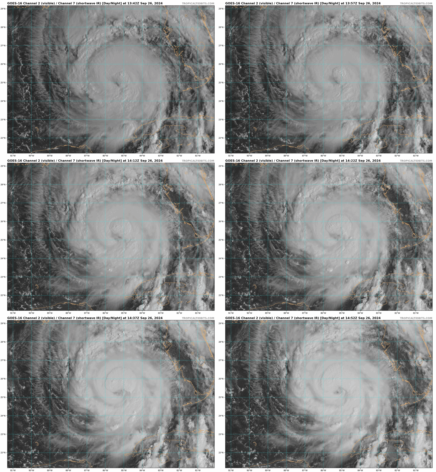
As highlighted in previous BMS Tropical Updates, Hurricane John in the East Pacific demonstrated how quickly storms can intensify. With less than 12 hours until landfall, significant changes in Helene’s structure and intensity are still possible. As of this morning, Helene remains a Category 1 hurricane, but it is on the verge of reaching Category 2 or 3. It could be upgraded at any moment, depending on data from hurricane hunters. The size of the Helene wind field is a vital factor, as widely reported in Hurricane Helene and discussed in these updates. Large Helene wind field is measured by the recon aircraft with 60 mph surface winds measured in a drop sonde around 125 miles east of the center. In fact, Helene seems to be similar to hurricane IKE in 2008, which had a massive windfall, but due to its size, it struggled to gain strength towards its landfall on the east end of Galveston Island as a strong Category 2 hurricane. Similarly, after Hurricane Katrina expanded in size, it struggled to regain its Category 5 status before making landfall along the Gulf Coast. What we are implying is that large storms often face challenges in intensifying. Overnight, Helene has also struggled to strengthen. However, early this morning, there are signs that Helene is developing a tight inner core—a structural shift that has not occurred until now. This formation could be the key to Helene's potential for rapid intensification. Remember, Helene, is tracking across some very warm water and, at the moment, is in a low-shear environment with a favorable upper-level dynamic due to the upper-level low over the southern central plains. Over the next 12 hours, Helene will still be in a favorable environment for intensification. The insurance industry should still expect a very strong category three or weak Category 4 hurricane at landfall, which still appears to be between Alligator Point, FL, and Nutall Rise, FL.
Helene Impacts
Storm Surge Impacts
Helene's Impacts will be far and wide due to Helene's size. Much of the state of Florida will see outer band thunderstorm activity that started yesterday. The PRE rainfall event that has been discussed here is already taking shape, with much of the southeast seeing rainfall, which will only continue until Helene passes through later tomorrow afternoon. Due to Helene's size, the Gulf Coast will see record storm surges, and if you are interested in seeing the observation of storm surge, you can look at the numerous NOAA monitoring sites along the Gulf Coast. Perhaps most notably, attention is focused on the potential storm surge in the Tampa/St. Pete areas, currently forecasted to reach 5-8 feet. This would rival historical surge records from past storms, such as the 1921 Tampa Bay hurricane, where surges were reported to reach or exceed 10 feet (3 meters). Still, official measurements were not as precise during that period.
Here is a link to the National Hurricane Center's Potential Storm Surge Flooding Inundation Map
Here is a link to NOAA Storm Surge and Tide Monitoring station, specifically for Hurricane Helene
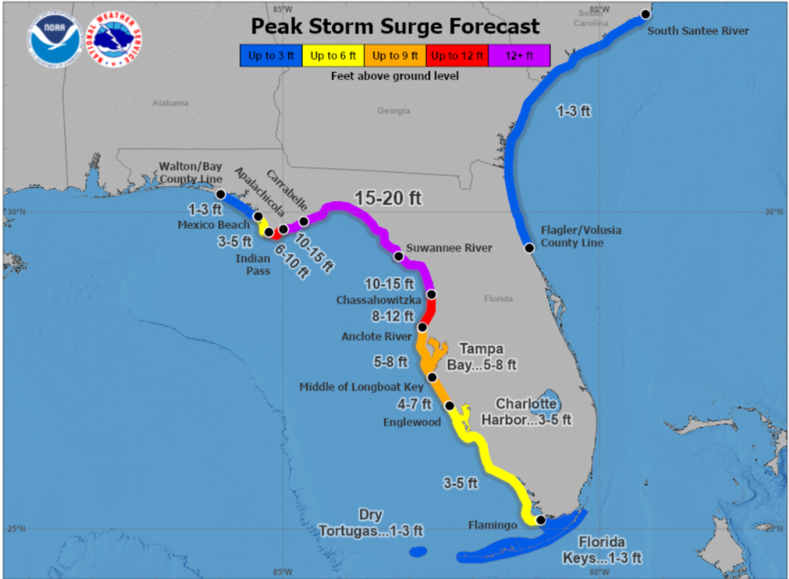
In the Big Bend region of Florida, the storm surge is expected to reach 20 feet. This raises the question of how high structures are in the areas. Granted, there is very little, if any, coastal development along the Big Bend region east of Alligator Point to Steinhatchee, FL. You can look at Google Maps along the coastline to determine this. Generally, regulations in the areas use Base Flood Elevation (BFE) as the primary standard for determining how high a structure must be elevated above sea level in flood-prone areas. The BFE varies based on FEMA flood zone maps, which assess the likelihood of flooding. BFEs typically range from 7 to 13 feet above sea level along the Gulf Coast, but in certain high-risk areas, they can exceed 15 feet. Along the Big Bend region, where the coast is shallow and prone to storm surges, local codes might impose stricter elevation standards to account for potential surges and rising sea levels. However, it is important to remember that the impact largely depends on whether buildings are constructed to code, which many are not. As a result, images of storm surge flooding in these structures should not come as a surprise.
Typically, with large storms like Helene, storm surge could pose a threat along Florida’s east coast, extending up to Georgia and South Carolina. However, at this time, storm surge is not expected to be a major concern. The astronomical tide cycle is currently between spring tides (with the moon just past the last quarter), so the elevated water levels are expected to stay below flood levels.
Wind Gusts Impacts
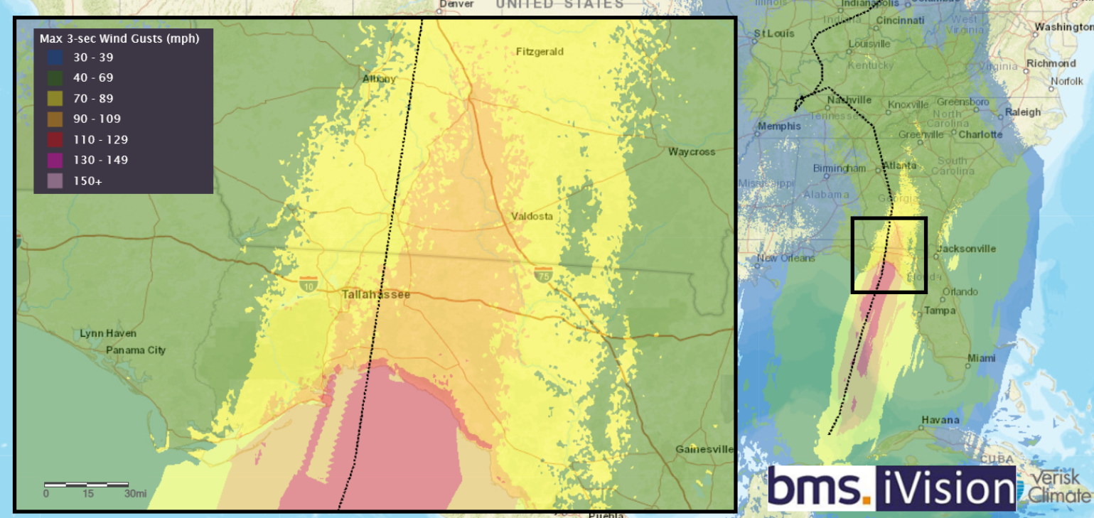
The best way to understand the highest wind areas is to use our BMS iVision Verisk Respond 3-second wind gust swath product, shown below. This high-resolution model is run four times a day and provides realistic views of Helene winds that could be experienced at the surface since the model has surface roughness built in, which you can see in detail when the wind speed weakens along the coastline. Due to the low levels of coastal development along the Big Bend region, the attention turns to how far inland will the strong winds extend and how close will the strong winds get to Tallahassee, which, as shown in yesterday's BMS tropical update, is the only major urban areas close to the landfall areas as the overall general landfall areas have a very low housing density. Due to Helene's fast-forward speed at landfall, higher winds will extend more inland than the typical hurricane landfall. The impacts will reach inland into Southwest Georgia communities like Thomasville, Moultrie, Valdosta, Tifton, and Albany, which can expect damage. Some sources may slightly exaggerate some of the wind estimates for extreme Northern Georgia. Still, wind gusts of 40 mph could occur in the Atlanta area, and gusts of 60 mph might occur in a narrow swath near Athens, GA. However, this will all depend on Helene's final track. As shown yesterday, tree density is very high across the path of Helene, and the ground is saturated, which will increase tree fall. In North Georgia, the drier ground and weaker winds mean that tree falls are not expected to be a significant cause of damage, unlike in the southern part of the state. It is worth noting that much of the rural Southeast is home to many manufactured homes, but even inland, well-maintained structures should experience minimal damage. However, the industry should expect any older roofs in the highest wind swath areas not replaced by Hurricane Michael (2018) to see damage from Hurricane Helene. Of course, there will be widespread power outages, but it seems the energy industry has crews staged across the region ready to respond, so the hope is to limit multi-day outages.
Tornadoes Impacts
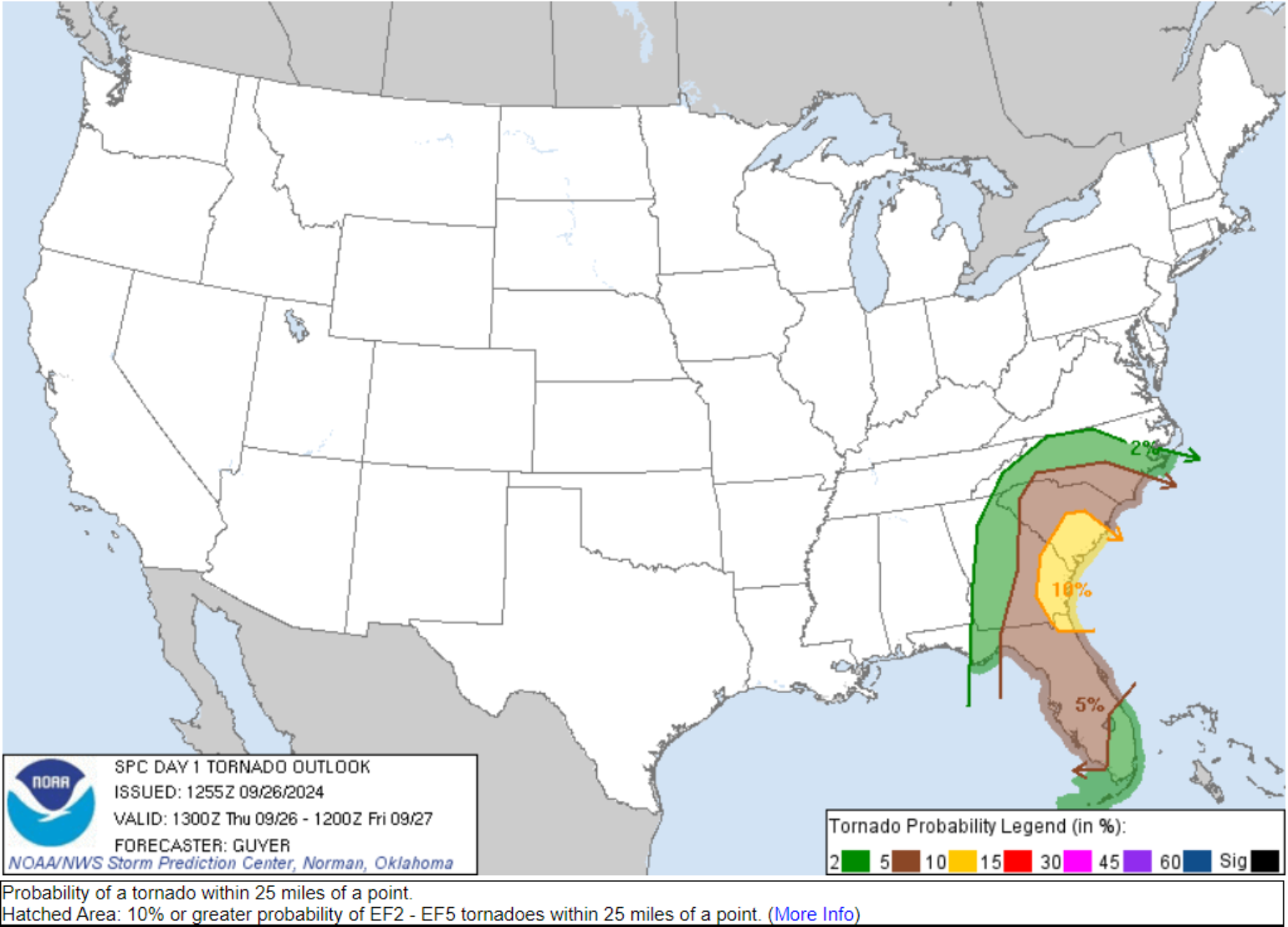
As is common with hurricanes making landfall, and as seen earlier this season with Hurricane Beryl, they can generate short-lived tornadoes. The Storm Prediction Center has the region in an “enhanced” level 3 risk with a 10% chance of a tornado occurring within 25 miles of a point. Remember that tornadoes forming within hurricane wind fields tend to be short-lived and weaker – F0 or F1. They can be dangerous to mobile homes, but reasonably well-built structures will generally see limited damage.
Rain and Flooding Impacts
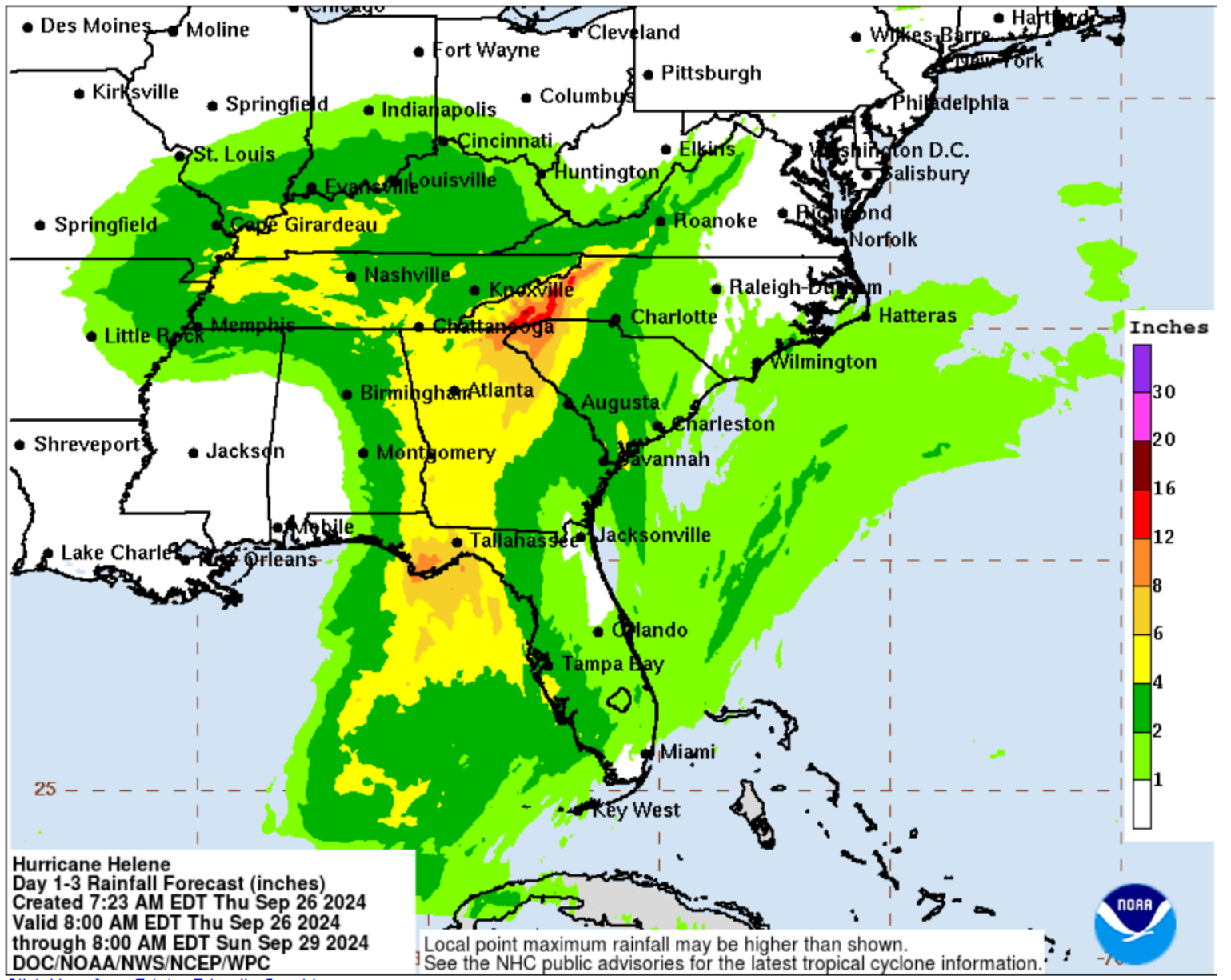
Daily rainfall records are expected to be broken across the region, but at this time, it does not appear that any flood records will be broken. In combination with the PRE event that has already started bringing rain across the region, a wide swath of 6-10” of rain will occur over the next three days, with the highest amounts occurring in Western North Carolina. Keep in mind that along the coastline, which is largely rural, and in inland areas, NFIP coverage is minimal, with some of the lowest take-up rates in the U.S. for coastal counties and similarly low rates inland. As a result, a significant portion of residential and commercial flood losses from this event are likely to be uninsured.
Insurance Industry Impacts
As with any storm of this magnitude, there will be considerable hype surrounding it. The media tends to amplify this, and the insurance industry should be aware of this pattern. However, it is also important to recognize that there are reasons to be less pessimistic. The insurance industry has come a long way in helping to build resiliency. This is not the area's first hurricane. As mentioned, the area has seen several hurricanes since 2016. Sure, they might not all be as strong as Helene, but Michael packed a punch, resulting in Tallahassee having wind gusts of 71 mph with high gusts lasting 12 hours. Tallahassee will be the key to the overall industry loss as the only central metro area threatened by high winds. On the current trajectory, the highest wind gusts will appear east of the city, with the town only experiencing wind gusts of 80 mph. But any shift to the West in the track will drastically increase insurance loss estimates. Higher wind speed in this older urban area with high tree density is still recovering from the May 10th tornado outbreak. Although Helene will have a large wind swath, there have been changes in policy terms and conditions to limit losses from lower wind speed events, particularly across the state of Florida, as it truly takes a catastrophic wind to cause insurance policies to respond. Right now, insurance losses should end up below $8B, with a likely range between $4 -$5.5B. Please be aware that any shift in the track toward the west, bringing it closer to Tallahassee, could result in higher losses. It cannot be emphasized enough that this is a predominantly rural area of the U.S. coastline, with limited coastal development exposed to the strongest winds. Just like Idalia made landfall in the same general area last year as a major hurricane, and according to the catastrophe risk model, this was one of the strongest hurricanes to make landfall to have such a low level of loss, and that was partly due to the rural nature of the landfall areas. Helene will likely fall into the same category: powerful hurricane but with reasonably low insurance industry loss.
Helene is the fourth landfalling hurricane on the US mainland in 2024. Beryl was a Category 1 in North Texas, Debby was Category 1 in the same areas Helene is impacting, and Francine was a Category 2 in Louisiana near New Orleans. The overall Atlantic hurricane season has fallen short of expectations in terms of projected activity, but the landfalls have undoubtedly performed with an above-average number of US hurricane landfalls. However, to date, all these losses have been quite manageable for the industry as combined losses are roughly $6B combined. Helene looks to be another manageable loss for the insurance industry as it continues to hold its breath for the next few weeks.
