8 Landfalls in 7 years!
In the past 24 hours, Hurricane John has undergone rapid intensification, reaching Category 3 strength just before making landfall south of Acapulco, Mexico. The storm has since shifted northwest, now battering Acapulco, a city still recovering from the devastation caused by Hurricane Otis last year. On the Caribbean/Gulf of Mexico side, Potential Tropical Cyclone 9 (PTC9) is still somewhat disorganized, and part of this reason is because of what happened with John in the last 24 hours. However, all the signs suggest that PTC9 will become Helene anytime and develop into a major hurricane once it enters the Gulf of Mexico tomorrow. For this blog, we will refer to Helene as PTC9, which again will be only the eighth named storm of the 2024 Atlantic hurricane season. PTC9 is forecasted to make landfall as a hurricane along the Northeast Gulf Coast. It would mark the fourth continental US (CONUS) hurricane landfall in 2024 (Beryl, Debby, Francine). Three other years since 2000 have had 4+ CONUS hurricane landfalls: 2004, 2005, and 2020. This year is notable for its overall low activity, but what truly matters to the insurance industry is landfall events, and this year has seen an above-normal number, with the season still ongoing. What is even more remarkable is that this marks the eighth major hurricane landfall along the Gulf Coast in the past seven years.
Model Watching
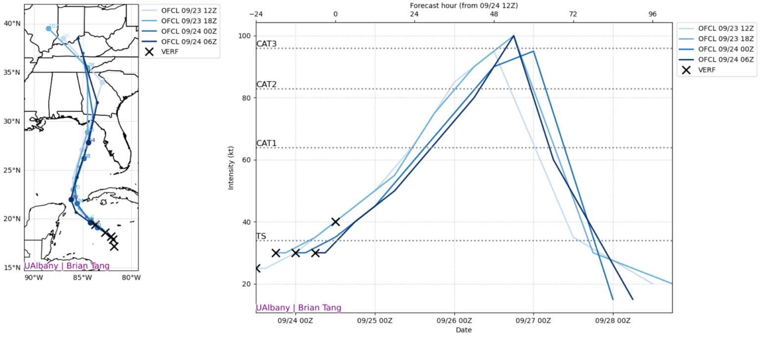
In today's world, where information is readily accessible and easily shared, it is easy to fall into the role of an "armchair meteorologist." However, as the BMS Tropical Update cautioned yesterday, it was too soon to make definitive conclusions about PTC9, particularly regarding its intensity. Over the past 24 hours, the insurance industry has learned a valuable lesson in patience. Late yesterday afternoon, model guidance shifted significantly, indicating much lower intensity at landfall. Overnight, the model once again increased in intensity.

There are likely a few reasons why the intensity guidance has shifted downward and back upward. Late yesterday, with better aircraft recon and a better understanding of a low-level center, the forecast models had a greater understanding of what they were working with than just guessing at initialization.
As discussed in yesterday's tropical outlook, upper-level wind shear could impact the development speed of PTC9. This has been particularly evident over the last 24 hours as general convection has been shunted on the west side of any potential development. Since Hurricane John was significantly stronger than anticipated, upper-level sinking air likely affected areas west of PTC9's potential development. As a result, despite model predictions from yesterday, we are still awaiting the official formation of a tropical storm this morning, which could occur at any moment.
Speaking of Hurricane John, what might occur with the development of PTC9 is quite relevant. Yesterday early morning, when John was first designated a tropical storm, it was only forecasted to be a tropical storm at landfall on the western coast of Mexico near the town of Marquelia in the state of Guerrero. However, Hurricane John made landfall last night with a peak intensity of 120 mph. In the final 24 hours before landfall, John’s intensity increased by 85 mph wind speed and explosively deepened by 44 mb of pressure. Reports are still coming in, but in addition to strong winds, John has had torrential rainfall that will indeed cause widespread risk for flash floods and large mudslides, including in and around Acapulco, Mexico. This is one of the most extreme cases of rapid intensification you will ever see, and it has come less than a year after catastrophic Hurricane Otis made landfall and had the same type of rapid intensification just a few dozen miles to the northwest. This tropical update suggests that this will happen to PTC9, but it simply highlights that John was much stronger than forecasted, which likely has played a role in PTC9's development. It also highlights how rapidly storms can intensify under favorable environmental conditions, something several forecast models continue to predict as PTC9 moves into the southern Gulf of Mexico.
PTC9 Intensity Forecast
Currently, PTC9 is weak and disorganized, but it is expected to gradually become better organized and become a tropical storm within the next 12 hours or sooner. Therefore, it could be tropical storm Helene before this is officially posted online.
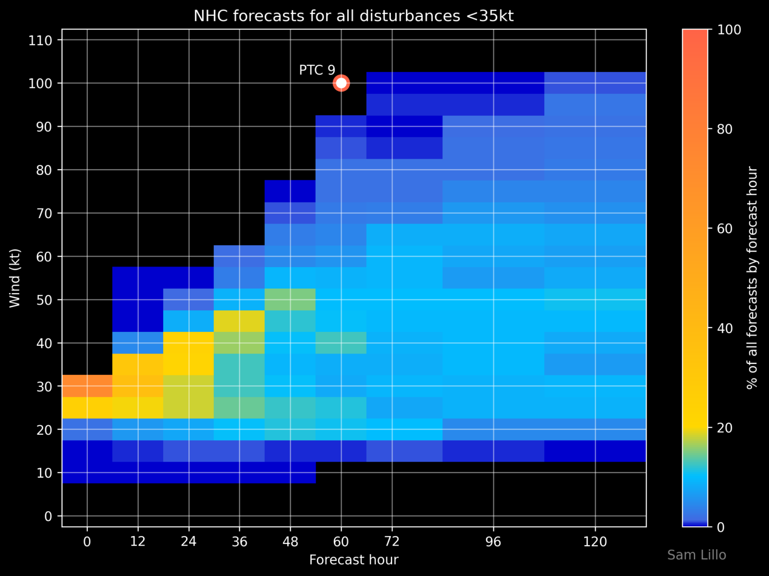
There are two reasons why PTC9 will likely undergo rapid intensification into a Category 3+ hurricane before landfall, which was discussed in the tropical update yesterday. As PTC9 lifts into the Gulf of Mexico, the upper-level low over the southern plains will add in what is called “venting.” The best way to describe this is to imagine the upper-level low as a leaf blower over a chimney. The upper-level jet stream will blow air at the top of the storm away, clearing the way for more air to rush up and replace it. This will enhance rising motion over PTC9 circulation once it is established. The second highlighted reason is the very warm sea surface temperature (SST), hot ocean heat content, and the overall position of the Gulf of Mexico loop current. So, with plenty of venting, warm SST, lots of moisture, and lower wind shear, even the NHC forecasts that PTC9 will rapidly intensify.


Another item to watch with the forecast is the upper-level low over the southern plain, and high pressure off the Southeast coast of the U.S. will pinch the flow, meaning that PTC9's forward speed will speed up as it approaches landfall. This indicates that inland impacts could be far more significant depending on landfall intensity. Currently, model guidance suggests a stronger wind swath with stronger wind gusts that extend, again, depending on the landfall intensity. It seems a Category 2 storm, and upwards of a Category 4, is not out of the question. That being said, until a well-defined storm with a named center of circulation forms, the models will struggle to initialize it accurately. The timing of aircraft data and better observations will influence this so that we can expect a wide range of intensity forecasts.
PTC9 Landfall Location
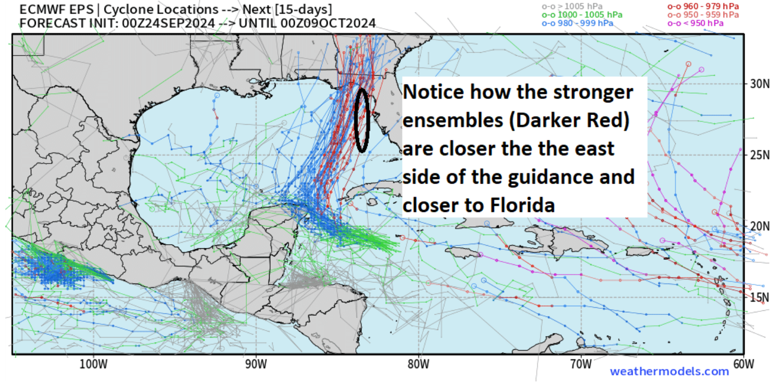
As expected, there has been a slight eastward shift in the general model guidance. Still, given the overall intensity guidance, there is consensus on the general landfall area across the Big Bend region of Florida.
Remember, this area is sparsely populated in many parts, and Debbie and Idalia provide excellent benchmarks as to what to expect. Although this will be a stronger storm, there will still be a lower insurance take-up rate and a smaller general population impacted.
If the current track holds, the area from Cedar Key to Tallahassee/Port Leon will be the area that experiences the biggest impacts, with regions from Panama City to Gainesville falling within the high wind zone of potentially damaging wind gusts and tree fall. Depending on the storm's size and intensity, the Tampa/St. Pete/Clearwater area could experience a near miss, where just a few miles could make a big difference in storm impacts. At this point, it is impossible to accurately predict the wind field due to uncertainty around the storm's intensity and size. This should be considered when Catastrophe risk model vendors release this very early model guidance. With its forecasted fast movement and landfall, South Georgia is also likely to experience strong inland winds, rain, and possible tornadoes.
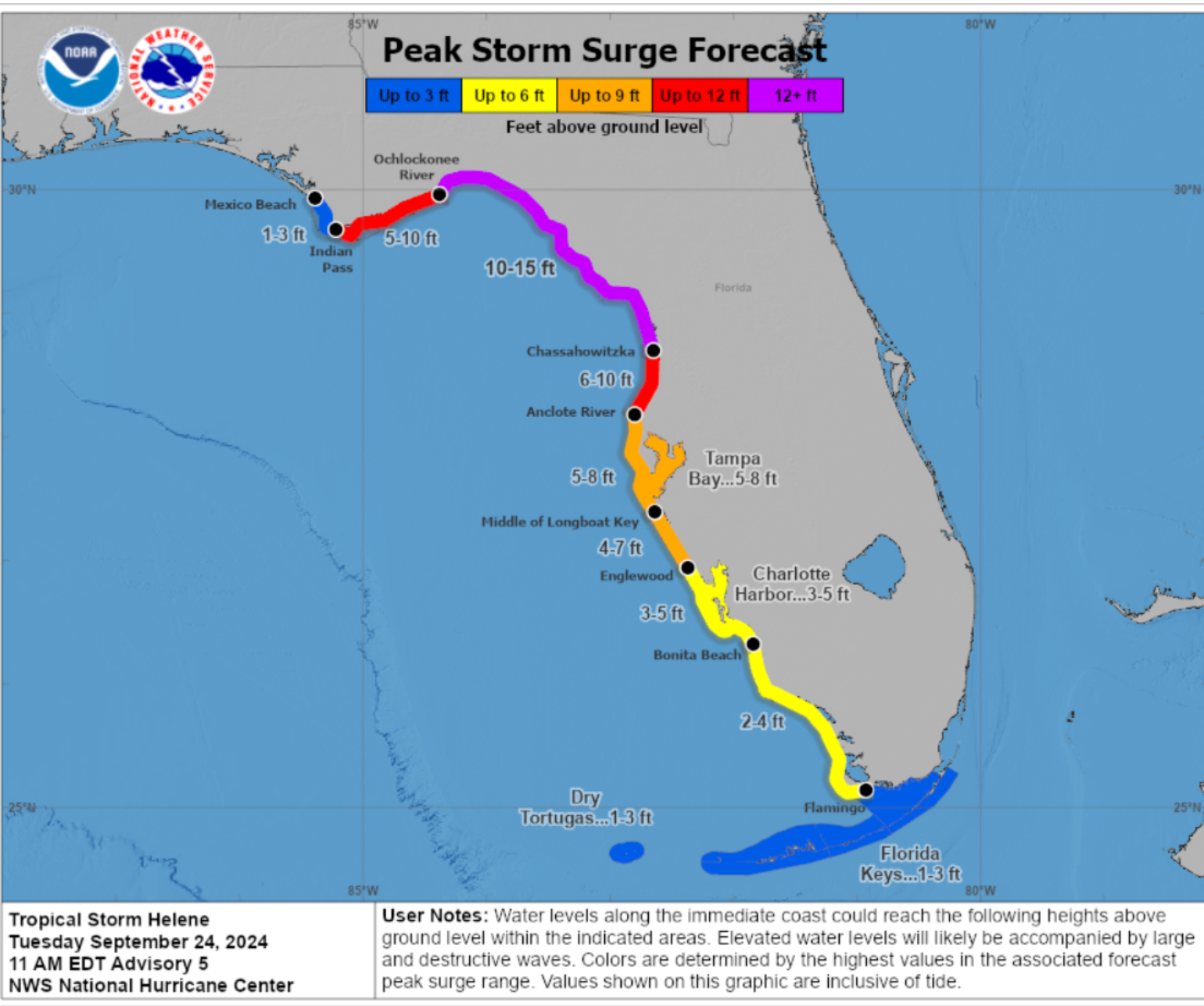
So, in general, landfall intensity guidance is highly uncertain at this time, which is why it is premature to make any judgments on landfall impacts and insurance loss estimates, as the loss range would not be very useful at this time. This is also why it is difficult to also understand storm surge impacts, that could be severe up the west coast of Florida, but this will depend on the size and intensity and how close PTC9 tracks to the coast, but the west coast of Florida and the Big Bend region are very prone to high storm surges given the bathymetry along the coastline.

Unfortunately, as noted yesterday, we will not have much confidence in these forecast details until the storm spins up and enters the Gulf. It is also essential to note that impacts will be beyond the NHC cone of uncertainty, so do not just think the cone is the area of impact. Depending on the track and intensity, Tampa could get hurricane-force wind gusts and heavy rain.
Speaking of rain, one thing that seems to also be in play is inland rain could be severe along with what is called PRE rainfall event in the vicinity of the Southern Appalachian mountains in western North Carolina.
The next big update will be tomorrow morning when the storm is expected to be in the Yucatan Straits. Intensity guidance, along with the expected storm size and forecasted forward speed, will be more confident.
