Quad State Tornado Outbreak
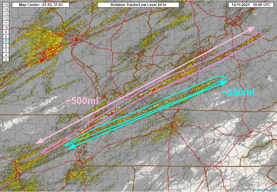
After what has been a fairly quiet fall severe weather season for the insurance industry, an explosive severe weather event unfolded on the evening hours of December 10th. While well forecasted from several days ago, this severe weather event has far exceeded the expectations particularly when it comes to the overall tornado impacts. Compounded by the fact many of the tornadoes were during the nighttime hours, the results have been deadly as the death toll climbs. Early indications are there at least 70 deaths and likely to climb, which would put this severe weather outbreak in the top 15 deadliest tornado days in U.S. history. Like most historic events, this severe weather outbreak gets a name and is being dubbed the Quad State tornado outbreak due to the intense tornado activity that has tracked across parts of four states: Arkansas, Missouri, Tennesse, and Kentucky. However many other states in the region experienced severe weather. The severe weather will continue to move into the East Coast of the U.S. but is not expected to be as severe. Overall it would appear that hail, which is one of the drivers of the average annual loss for the insurance industry, was limited in this event. This follows the trend that currently hail report counts from NOAA are being observed at an all-time low as far as occurrences. The Quad State event losses will be driven by wind and tornado losses. Keep in mind, tornado losses drive the tail of larger insurance industry loss events.

The Magnitude Of The Outbreak
It is still extremely early and the local National Weather Service offices will start the complex task of rating all the tornadoes that have occurred, but early indications are that one of the tornadoes that occurred is likely the first EF5 tornado ( winds above 200 mph causing sufficient damage) in Mayfield, KY, which would end the long-standing U.S. EF5 tornado drought.
Slabs everywhere. Slab: The concrete foundation of a home. This is on Cardinal Road right off of US45 southwest of downtown Mayfield. #kywxpic.twitter.com/6WfaCzIWuD
— ☈ Chris Jackson ☈ (@ChrisJacksonSC)
The last occurrence was 3,125 days ago on May 20, 2013, impacting Moore, Oklahoma. More on this historic tornado drought can be read in this BMS Insight. There is also an indication that one of the tornadoes might be one of the longest-lived tornado tracks in U.S. history, tracking over 250 miles. The longest tracking tornado in history is 219 miles which occurred on March 18, 1925. Tornado warnings associated with one of the tornadoes extended a staggering 385 miles with overall 146 tornado warning counts issued across several states which would put this outbreak in the top three 24 hour periods during the winter months. There is also an indication from weather radar that debris from one of the tornadoes was carried 7 miles (35,000 feet) into the air. All of these tidbits indicate truly a historic tornado outbreak.

Overall the cause of this severe weather event was similar to some of the major severe weather outbreaks that occur during the spring months with a developing mid-latitude cyclone bringing heavy snow to the North and a line of severe weather that extends along a frontal boundary where the warm and cold air collide. When you combine the rare warm air (80 degrees F. in Memphis, TN) for December across the Southern states and this colder arctic air ( 30 degrees F. Minneapolis) and the winds from opposite directions that veer with height that cause a spin in the upper atmosphere condition are a recipe for tornadoes.
Largest December Severe Weather Insured Loss
So far, the NOAA Storm Prediction Center has 37 tornado reports and 258 strong wind and damage reports with some hail being reported in Texas and Arkansas, and Missouri. The catastrophic damage appears to be in Mayfield, KY. A large swath of the town was leveled which is likely the area of EF4 maybe EE5 tornado damage. According to FEMA, the general exposure in the census tract of Mayfield, KY that makes up the town of 10,000 easily reaches $1.2 billion in building value.
This pretty much sums it up in :19. #Mayfield#MayfieldTornado#KyWx#WXpic.twitter.com/IcPL4XGtPS
— WxChasing- Brandon Clement (@bclemms)
This is just one of the communities that have been impacted. Many more have been impacted and clearly, a tornado tracking 250 miles will result in an overall large area of damage, making it difficult for quick assessment. This does not account for the other wind impacts from other tornadoes and severe thunderstorm winds that have impacted several states.

While it is too early to put a figure around the total losses to the insurance industry, events like this typically run into the low single-digit billions of dollars range. The largest December severe weather event typically averages only in the range of $100 – $200 million of insured loss with the largest rarely exceeding $500 million. This will be one of the costliest severe weather events for the month of December which typically counts on a quiet fourth quarter. With most of the insurance industry loss in the fourth quarter focused more on European wind storms and California wildfires, large U.S. severe weather losses are rare. Severe weather outbreaks can happen any time of the year across the U.S., but overall the conditions here are extremely rare in December. With severe weather insurance industry losses in the U.S. already running around $20 billion for the year. This event is an unwelcome surprise for the insurance industry which will add to an already costly year of natural catastrophes for the insurance industry which has already experienced four billion dollar severe weather loss events so far this year.


