

If you have ever attended one of my weather trend talks you may remember that I often include a slide on how weather memory is generational. We often only remember back to the last major weather event that has impacted us personally. Less extreme weather events are even harder to recall, and when you compound this with the fact that extreme weather is infrequent, remembering the last occurrence of such events is difficult.
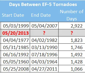
With that being said the U.S. is quietly in a remarkable EF5 tornado drought. The last EF5 tornado to be observed in the U.S. was a devastating violent tornado that impacted the towns of Newcastle and Moore, Oklahoma at just after 2 pm on May 20th, 2013. The tornado claimed 24 lives, had inflation insurance adjusted loss of at least $1.3B, and much higher economic losses.
This catastrophic event was 2,920 days ago and this is significant because in just 2 days if an EF5 tornado does not occur it will break the record for the longest period between major EF5 tornado occurrences in the current observational record dating back to 1950. The longest stretch currently stands between May 3rd, 1999, and May 4th, 2017 at 2,922 days. These long stretches between major disasters like this are big news for the insurance industry due to the fact they often result in very high claims payments due to their catastrophic winds of 200 mph or greater. In fact, tornado alley, known as a tornado hot spot, has seen a lack of tornadoes for the last few years. For example, last year the total tornado count in smaller states (NJ, DE, CT, MD) in the East Coast were more than those observed in OK or KS. Even this April not even a dozen tornadoes have been reported across Texas, Oklahoma, Kansas, and Nebraska. The entire country has had a relatively quiet April in terms of tornado activity, with 73 preliminary reports, which is below the three-year average of 224 tornadoes.
Although, severe weather activity is picking up in the central plains over the last several weeks. Most of the severe weather activity so far this year has been across the Southeast U.S. - which is typical of early season activity and of some of the past La Niña years. La Niña is the phenomenon involving the cooling of sea surface temperatures near the equator in the Central Pacific Ocean. In some years, when there is a strong La Niña, it could have an impact on increased tornado activity in the southeast. This does not explain the decrease in activity in the central plains, which should also see an increase during a La Nina spring as well. However, it should be noted, just last week NOAA Climate Prediction Center declared the current La Niña has ended. Atmospherically La Niña should not have much more influence on the spring or summertime weather phenomena.
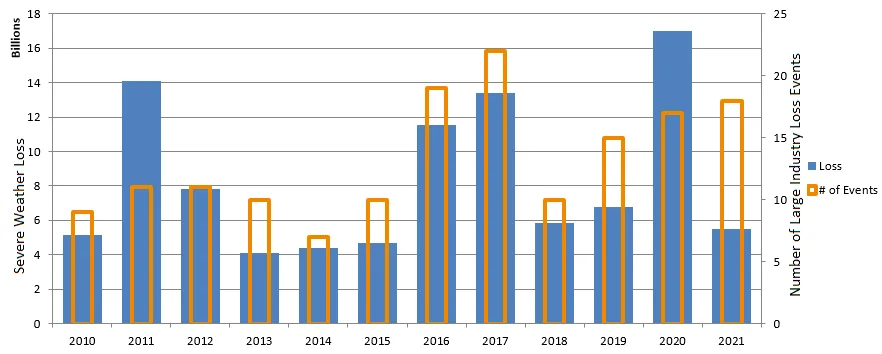
Regardless this lack of activity is good news for the insurance industry that has a hard time quantifying the impacts of tornado events, which are considered a tail event when they do occur. On average, hail and other thunderstorm wind impacts are the biggest driver of insurance loss with hail being on average about 60% of the average annual loss in any given year. Thus far this year the insurance industry has experienced 18 severe weather events of $25 million or more. That equates to a preliminary total loss of just over $5B with some loss development yet to occur. When compared to last year, which had 17 severe weather events year-to-date, it is clear that the severity of those events was much higher. 2021 so far is more in line with years like 2018 and 2019.
The 2021 severe weather season has been active in terms of the number of industry-impacting events, including some tornado losses. However, one of the biggest outbreaks of 2020, which occurred on March 17th with 61 reported tornadoes, largely missed the major populated areas. This leads me to my closing point. Although there is a remarkable EF5 tornado drought occurring, the rating of tornadoes is a function of the damage a tornado can do when a structure is impacted and the imperfect way that experts gauge tornado intensity. Outbreaks, such as the ones on March 17th, that have many tornadoes go through rural areas and leave little damage make it difficult to rate the severity of the winds the tornado might have. A recent study by the University of Illinois Department of Atmospheric Sciences suggests 20 – 25% of tornadoes boast winds speeds that would cause EF4 or EF5 winds and that on average tornado ratings are 1.2 – 1.5 categories too low. Since the core objective of the Fujita method is rating tornadoes to infer wind speeds based on upon damage, there are major flaws in this rating system when tornadoes do not hit anything to cause damage. When this is combined with the fact that all buildings are constructed and age differently over time there are issues with the ratings. There is a push to change how tornados are rated via radar wind speeds when available. This means there is a chance in the future that observations of major tornadoes will increase, and thereby change how we understand building tornado-resistant structures. Furthermore, this could even impact how the insurance industry has to price for such potential damages given that the current rating might be misaligned with what we perceive as a lower risk.


