Conference Season = Hurricane Season
The insurance industry might need to reconsider holding so many conferences. It seems like every major event this year has coincided with a landfalling hurricane. At Rendez-Vous de Septembre (RVS), the focus was on Hurricane Francine's impact on Louisiana. The National Association of Mutual Insurance Companies (NAMIC) Annual Convention centered on Major Hurricane Helene, and now the American Property Casualty Insurance Association (APCIA) is set to tackle what could be the marquee event for the industry: the developing Hurricane Milton and its potential impacts across Florida.
Yesterday’s tropical update highlighted key aspects of what is known as a “Gray Swan” event—an event that is anticipated but carries uncertain consequences. That remains true today, as the insurance industry faces what could be one of its largest losses this hurricane season. The update also discussed the historical rarity of a storm tracking eastward across the Gulf of Mexico and making a direct, perpendicular landfall on Florida’s west coast with such intensity, something that has not occurred in decades or, in some cases, over a century.
Current Status:Milton is now a major hurricane, Category 4, almost 5, marking the third of this 2024 Atlantic hurricane season. Milton has shown an impressive pressure drop in the last 24 hours. This morning, NOAA Hurricane Hunters first passed through Milton and found the pressure had plummeted down to approximately 933MB. The 4 am advisory had a pressure of 972mb. The rapid intensification is remarkable. The formation of a pinhole eye may explain this explosive strengthening, but do not be misled by Milton’s small size. With almost the entire Gulf of Mexico ahead, the storm’s shape and size could still evolve significantly, which will be crucial to the forecast and may have major implications for the insurance industry’s overall losses from Milton.
In the short-term forecast, Milton is expected to approach Category 5 status within 24 hours, and it would not be surprising if it reaches that level. Milton will be in an ideal environment for strengthening with low wind shear, warm sea surface temperatures, and plenty of moisture.
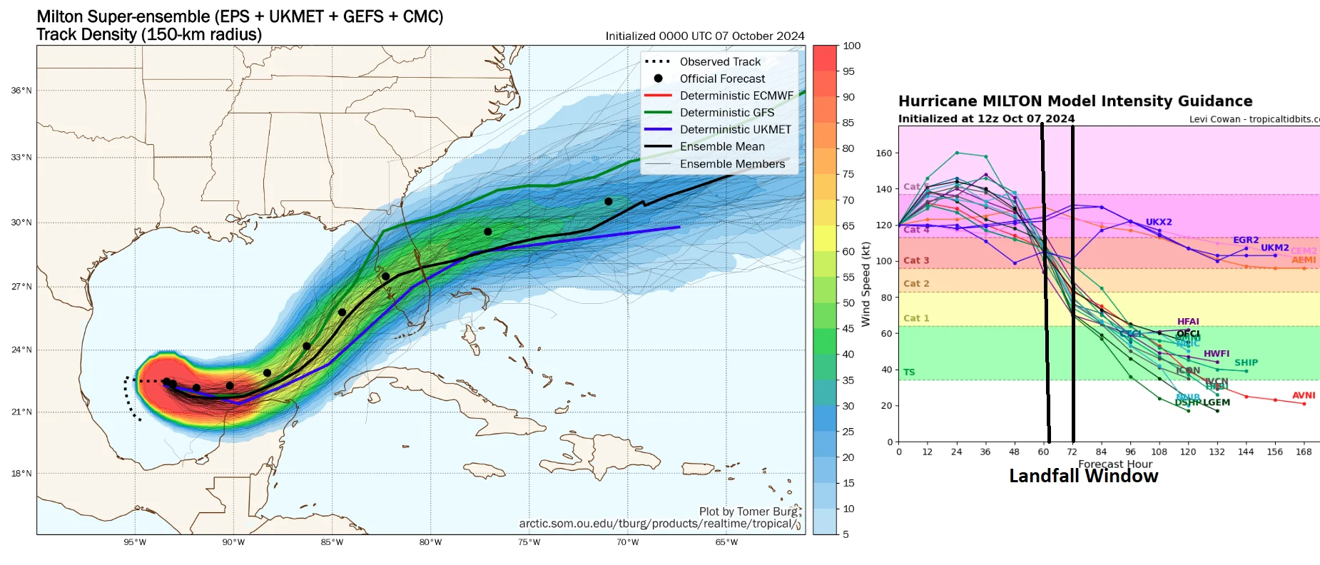
Track Forecasts:There has been a slight model consensus shift in a landfall location over the last 24 hours to the south of Tampa. Still, this shift is too close for comfort to Tampa, and any landfall location along the central west coast of Florida will be a major event for the insurance industry. The North American weather pattern and the upper-level trough that will steer Milton toward Florida are still developing, so there is some forecast uncertainty. The forecast models are not as locked in as they were with Helene, and the latest super ensemble shows just how much uncertainty there is between the GFS and UKMet Model, with the trusty ECMWF model in the middle of the consensus.

For good reason, much attention has been focused on Tampa Bay, highlighted in our Tropical Update Yesterday, as this would be the worst-case scenario and the Gray Swan event the industry has been discussing for decades. With all the focus on the potentially catastrophic impacts on Tampa, we need to keep in mind that while a southward track south of Tampa would mean a smaller damage number, a lot of people live in that part of Florida, including communities like Sarasota, Venice, Port Charlotte, and if the storm is large or farther south, Sanibel/Cape Coral/Fort Meyers. Track means everything, and it is not just for the west coast of Florida. As Milton moves onshore, the most substantial surge and winds tend to be on the storm's right side to the south of the track. However, on the east coast of Florida, the risk zone will shift to the north side of the track as the winds spin counterclockwise, so areas like Daytona to St. Augustine will see coastal impact.
The last couple of NHC forecasts have a landfall of Longboat Key, but keep in mind that track error is about 100 miles, meaning we cannot solely focus on Longboat Key as the landfall location. A landfall north of Tampa Bay (worst-case scenario) is still very much on the table, as shown in the latest BMS iVision Verisk Respond product below. This is just one forecast that gets updated four times daily, but this one scenario shows the strongest winds going right over Tampa / St. Pete. This would also push record storm surges into Tampa Bay and Sarasota.

Intensity Forecast:Above, we already highlighted that Milton could become an intense Category 4 hurricane and potentially reach Category 5 status. This is expected to occur by Tuesday Night. After Tuesday Night, Milton will encounter a much less favorable environment with strong shear and dry air entrainment. Sea Surface Temperature will be plenty warm, but this season has shown that you need perfect conditions for the intensification of named storms. Therefore, some weakening is anticipated before the hurricane reaches landfall on what looks to be Wednesday early evening. However, just because Milton might be weaker before landfall does not mean it will not be impactful. Think about all the recent storms that have weakened before landfall: Rita (2005), Katrina (2005), Ike (2008). In fact, what might occur, as illustrated in the BMS iVision plot above, is that Milton’s overall wind field will expand. This could create a less concentrated core of strong winds but a wider wind swath, further enhancing damage over a much wider area. Along with this increase in size will be the storm's ability to push water up along the coastline.
As mentioned above, Milton also interacts with the upper-level trough and starts its extratropical transition; the wind field on the left side may be markedly stronger than the right. This could lead to strong wind gusts from Orlando to Daytona on the back side of the hurricane.
Still Uncertainty in Impacts It is still too early to delve into specific impacts, as the uncertainty regarding the landfall track will significantly influence damage estimates, potentially amounting to tens of billions. This is why the catastrophe modeling output to be released will show a broad range of loss estimates. Each one of the tracks will be sensitive to the landfall location and intensity. In fact, in some cases, modeling firms might hold off on issuing early guidance given the forecast uncertainty and the large loss range as right now, an industry loss could be as low as $10B but as high as $100B, so overall guidance is not very useful given the uncertainty.
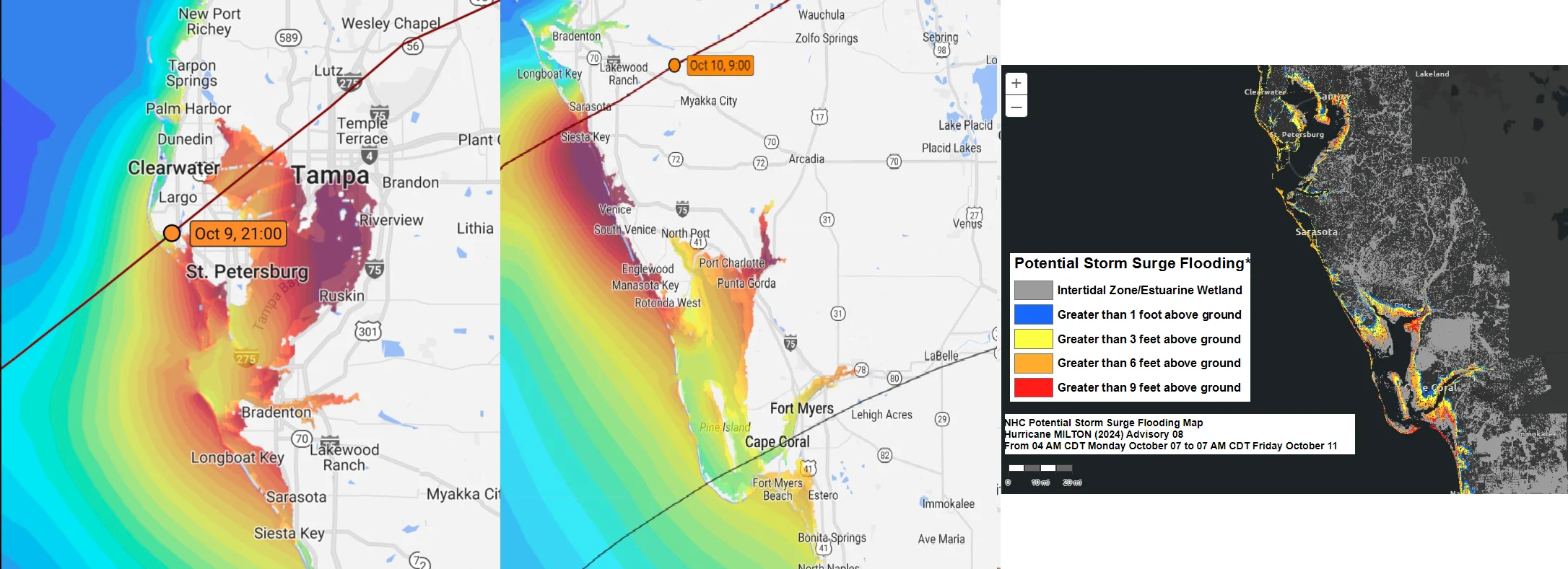
To illustrate the forecast's sensitivities, Jeff Berardelli, a meteorologist at WFLA TV in Tampa, shared two different storm surge scenarios. The image below shows a forecast path of Milton taking a track just north of Tampa with a storm surge well over 10+ feet into Tampa Bay. The other image is of a storm track south of Tampa, and water would get sucked out of Tampa Bay, resulting in a much higher storm surge to areas of Vence/ Port Charlotte, FL.

Regardless of these scenarios, the flood insurance take-up rate, according to the NIFP, is in some cases over 25% for some western central coastal counties of Florida. As we discussed yesterday, a storm surge event in Tampa qualifies as a Gray Swan event and has posed challenges for the insurance industry for decades. The last time Tampa suffered a direct hit by any hurricane was in 1946 when a Category 1 storm came up through the bay. The Tampa Bay Hurricane of October 25, 1921, was the last major hurricane to make landfall in the Tampa Bay region. Not only have the structures not been tested from a significant hurricane, but the people and infrastructure have not either. If you want to know more about the potential impacts, the Tampa Bay Times did an excellent two-part series in 2022, which, given Milton's threat, everyone in the insurance industry should read.
Saturated Soil and Tree Fall
One thing that stands out is that water has become the new wind. On top of the record storm surge that is forecasted depending on landfall location, Milton is forecasted to come with record-breaking precipitable water values according to the ECMWF forecast. Rain will be significant on the north side of Milton as it crosses central Florida. A swath of 10 or more inches of rain is very possible along and north of the center track. In fact, some areas could see as much as 15 inches of rain, and with already saturated soil across the state, this will increase tree fall, and therefore property damage.

Helene ImpactsThere are no signs in the current forecast that this storm will have major impacts on coastal Georgia or South Carolina, much less inland Georgia and North Carolina, which are still recovering from Helene. However, along the Gulf Coast, that is not the case. Once again, there are miles and miles of trash and debris cluttering the streets along the west coast of Florida. This could create significant challenges depending on the severity of the storm surge in certain areas. It is unlikely that cleanup will be completed before Milton arrives, so the focus should now be on evacuations and storm preparation.

Today, the Tampa Bay region has a population of over 3.5 million residents, many of which have never had to deal with a direct landfalling hurricane. Florida state officials have indicated that they plan to implement what could be the largest evacuation since Irma in 2017. This alone should signal to the insurance industry that there are no favorable outcomes. During the most recent insurance industry conference, discussions centered on the potential tens of billions in damage that Milton could inflict.


