The Main TopicThis week is significant for the insurance industry, with many leaders gathering at the 66th Rendez-Vous de Septembre (RVS) in Monte Carlo. A key topic of discussion may be the current activity in the Gulf of Mexico and the unusual occurrence of having three hurricanes already this season, all of which have made landfall. Another point of interest is the relatively low impact on the U.S., with Tropical Storm Alberto and Hurricanes Debby and Beryl causing a combined total of $3.4B in damage, thanks in part to their weakened landfall strength and fortunate landfall locations. However, with today marking the climatological peak of the Atlantic Hurricane season and Hurricane Francine now targeting Louisiana, many in attendance and across the industry are anxiously awaiting the outcome of Francine's landfall and the remainder of the season.
For those reading this update, perhaps late into the evening at RVS, and concerned about Francine’s potential impact on the insurance industry, this update aims to provide the essential guidance and insights you need to navigate the conversation effectively.
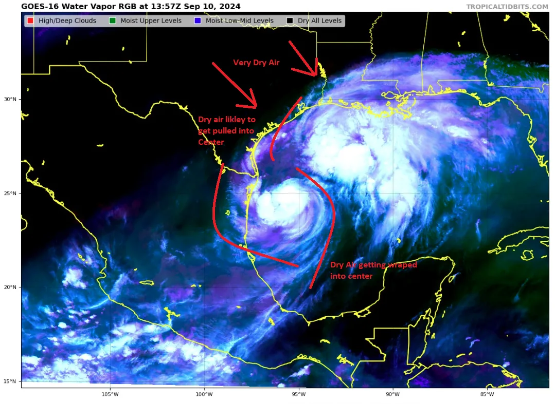
Current Structure of FrancineLet us begin by delving into Francine's current state. The storm seemed to gain intensity yesterday afternoon, with some signs of an eye-like feature on the Brownsville, Texas, based on radar and satellite images. This burst of structure led Francine to draw in dry continental air from Mexico, which slowed down any further intensification and deep convection overnight. As of this morning, it seems that any intensification has plateaued due to this dry air mixing into the storm's center. However, as Francine moves north and away from land later today, it is expected to intensify and could potentially become a hurricane. It is crucial to note that the window for rapid strengthening is gradually closing.

Water TemperaturesNamed storms love warm water, which is essential for storm formation and strengthening. Yesterday's tropical update showed that the Gulf of Mexico has record heat content. With that being said, it is imperative to note that over the past ten days, there has been heavy rain along the Gulf Coast, which has led to some cooler water in close to the coastline. As a result, it is possible that this will help stabilize or weaken Francine leading up to landfall tomorrow night. Even where it is below normal along the coastline, it is still plenty warm. Yet, when combined with dry air and wind shear, these are maybe three factors that suggest Francine will not be a strengthening storm right up until landfall like several previous storms in recent years.

Expected Landfall and intensityOverall, storm development is complex. As exemplified throughout this year, you can have the warmest water in history in the Atlantic Ocean but have limited storm development if other ingredients do not come together. Given factors like dry air and wind shear and maybe slightly cooler water near the coastline, strengthening might be delayed as Francine lifts northward. This means the storm could be weaker at landfall and closer to the Texas coastline, as lower-level winds typically steer weaker storms.

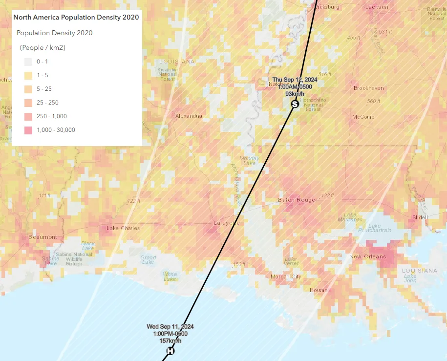
If Francine can come together and defied some of the dry air and shear, it would be stronger and track closer to the east side of the NHC track guidance. So, the overall intensity is determined by the track. A weaker lower-end category 1 or tropical storm system is likely to remain closer to the left side of the National Hurricane Center Cone. A stronger system of category 2 (very unlikely) is closer to the right side of the NHC cone of uncertainty. Remember, the cone of uncertainty is a tool by the NHC to show the likely path of a hurricane center, and on average, 2/3 of the time, the storm's center will remain in this cone. Also note that the strongest winds and highest impacts will be on the right side of the storm track. Given the current track, Francine would make landfall in a lightly populated part of southern Louisiana but may later bring tropical-storm-force wind gusts to Lafayette and Baton Rouge.

Wind ImpactsOne important aspect that might have changed since yesterday afternoon is that the official intensity forecast from the NHC has now been adjusted downward. They had been at the high end of the model guidance at 85 knots (100 mph). (Now 75 kts and 85 mph). Most model guidance has the storm making landfall as a solid category 1 and the trend keeps going down to maybe even just a tropical storm . Still, some negative factors might limit intensification as of now, but if those factors do not influence Francine, a stronger storm can be expected.
Below is the BMS iVision Verisk Respond product. This deterministic weather model shows a stronger track to the east of the National Hurricane Center Track. This would provide a conservative view of the worst-case scenario for the insurance industry, as stronger winds would be over the more populated New Orleans areas. At this time we are advising clients that there is only a 15% chance or this forecast verifying and outside of the NHC cone of uncertainty.

Rainfall Flooding Surge Impacts:The storm should be moving along well enough so that rain would not ordinarily be a huge threat. However, the Gulf Coast has seen a lot of rain in the last month, and things are pretty saturated. This will cause localized flooding as the rain amount in the area is expected to be six to nine inches. This saturated soil could also increase tree fall due to soil saturation and high wind gusts. Due to the smaller expected structure and angle of landfall, storm surge should not be a big concern at this time, even though much of the landfall areas are low-level swamps.
Tornado ImpactWith respect to any landfalling hurricane, tornado impacts are likely. Similar to Beryl, there could be significant tornado impacts once Francine moves inland. As indicated by the storm prediction center, there is a 5% chance of a tornado within 25 miles of a point along the Gulf Coast. {Show tornado probability}

Insurance ImpactsLouisiana is no stranger to named storm impacts since 2020. In fact, to some, it might be surprising that since 2020, 25 named storms have impacted the U.S. coastline, and 40% of those have had some influence on the state of Louisiana. The state has been under stress due to all of this activity, which has resulted in major changes in policy terms and conditions to limit loss from named storm events, such as the implementation of higher percent deductibles. Actual Cash Values on the roof are also becoming more of the norm. In general, on the personal lines side, over 825,000 claims have resulted from named storm activity since 2020. We know from stronger storms like Laura, Delta, and Ida a few of these storms resulted in thousands of roofs being replaced, which hopefully were replaced with higher architectural shingles, which should easily handle a category 1 or 2 landfalling hurricane. The Louisiana Fortify Home Program has provided over $2B in federal assistance to repair and rebuild homes across the state to a higher standard. Recent storm activity and ongoing rebuilding efforts should help limit damage to areas previously impacted. However, since Francine’s current path lies between the landfall zones of recent hurricanes, some regions that have been spared in past storms may not be as fortunate this time. Nevertheless, with Francine expected to make landfall as a lower-end hurricane, combined with the factors outlined, this event will likely result in a manageable, albeit retained, loss for many carriers in Louisiana.
There are numerous offshore oil and gas assets in the region, but while production will be paused for a few days, these facilities should be resilient enough to withstand a storm like Francine. A primary economic concern lies with the 15 refineries located in this area. However, over the years, the U.S. has reduced its energy dependence on the Gulf of Mexico, with only 15% oil production and 5% of gas production now coming from this region. Additionally, much of the older, weaker infrastructure has likely been upgraded due to previous storm damage, similar to how the insurance industry has strengthened its approach.
In conclusion, today marks the climatological peak of the season. While the season has been very active in terms of landfalls, the insurance industry has fared relatively well in the first half, according to seasonal forecasts. However, with Francine’s looming impacts and the potential for the second half of the season to return to more typical activity levels, the industry will need to remain cautious and prepared for what is ahead.


