

With the advent of social media over the last decade, so comes the pain of being fed clickbait from wishcasters, armchair meteorologists, and sometimes the mass media. This leads to hypocane, a long-range forecast of a hurricane making landfall along the U.S. coastline. This BMS Tropical Update will determine if there is any hype about Hurricane Lee that has formed in the Main Development Region (MDR). As discussed in the BMS Tropical Update posted one week ago, this would likely be the season's first long African wave to watch of the 2023 Atlantic hurricane season.
If you have been watching the various long-range forecasts over the last week, you might get caught up on the back and forth that long-range weather forecast models provide or that one hypocane that shows a U.S. landfall. You might also note common biases in the long-range forecast models while watching these. One bias is that they often take a named storm in the MDR and track it into the more northern latitudes too fast. Suppose you have been watching the National Hurricane Center (NHC) cone of uncertainty and reading their discussion. In that case, they have noted that their forecasts have generally been on the left side of the forecast model guidance due to this bias.
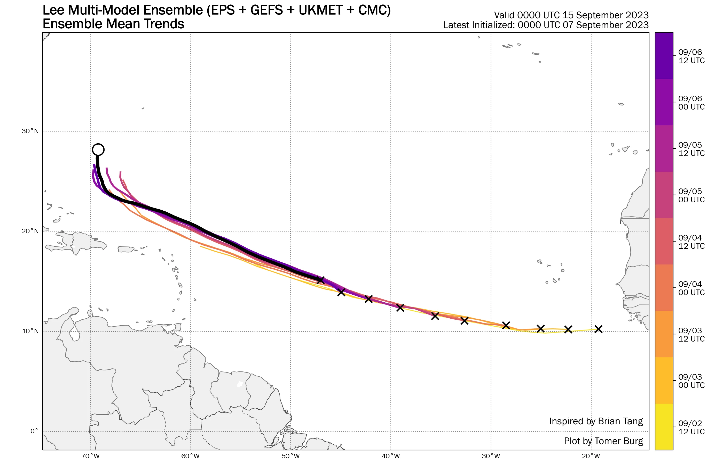
The important aspects that need to be watched are the trends. In the case of Hurricane Lee, the overall steering currents in the long-range forecast as the hurricane continues to track westward toward the Northern Caribbean Islands need to be monitored. These currents are dubbed as a “Fish Storm,” that at this point, would likely provide large waves, dangerous rip currents, and beach erosion to the northern coasts along the Caribbean islands.
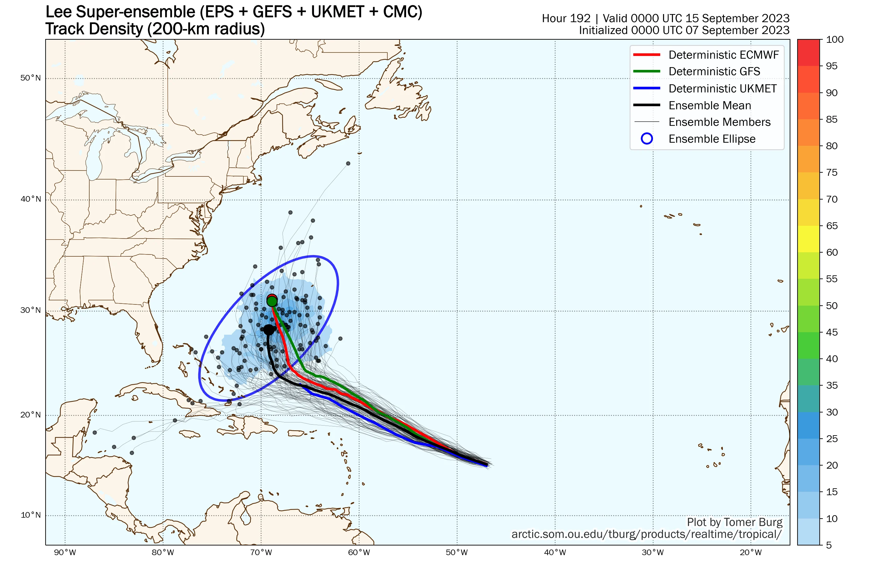
The NHC 5-day cone continues to bubble out a little more with each forecast, which means there is a bit more uncertainty in the long-range and the overall forward speed of Hurricane Lee. Beyond this Sunday, the forecast gets very interesting since the North American weather pattern that steers Hurricane Lee is resetting. Due to the uncertainty on how these certain features evolve, the impact of how Hurricane Lee tracks later next week remains unknown. Lee could stall several hundred miles north of the Greater Antilles while waiting for large-scale features to set up. By Wednesday next week, several super ensemble members have Hurricane Lee on the move north with an East Coast troughing and a subtropical ridge north and east, allowing Hurricane Lee to track to the North. By next Friday, the spread by the super ensemble members will increase. The hurricane could be anywhere from the north of the Turks and Caicos to the north of Bermuda. Right now, Bermuda should be watching Lee, and we cannot rule out impacts for the northeast USA and maritime Canada. Given the ensemble mean forecast, we know this will be a huge wave machine for the eastern parts of the coastline along the eastern U.S. as Hurricane Lee increases in intensity.

According to the NHC, Hurricane Lee is forecasted to become a Category 4 hurricane by September 9th. In fact, a Category 5 cannot be ruled out as well. If it does so, it would be the 3rd Category 4 hurricane of the 2023 Atlantic season (Franklin, Idalia). Phil Klotzbach from CSU says on X said that only 4 years on record have had 3 Category 4+ hurricanes by Sept. 9th: 1933, 2004, 2005, 2017. Clearly, the El Nino shear that let up a few weeks ago is sure creating a period of activity as expected towards the peak of the season, now just three days away. The good news is that after Hurricane Lee, there is a possibility that things go quiet for most of September.
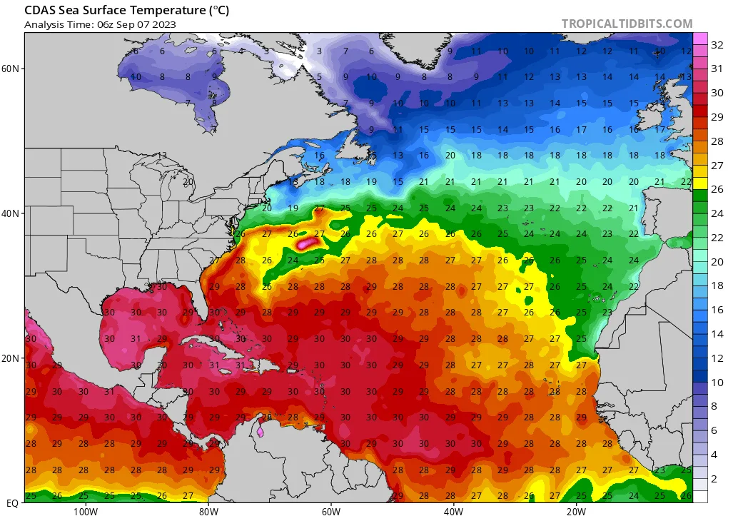
Hurricane Lee will traverse high ocean heat content [OHC] as it tracks to the north of the Leeward Islands and Puerto Rico in the tropical Atlantic over the next 5-days. However, the slow-moving, large Hurricane Franklin wiped out the OHC afterward. This, in addition to the increase in wind shear should weaken Hurricane Lee as it tracks north if the super ensemble track is followed.
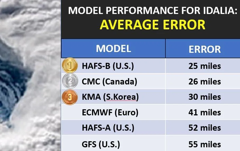
Model Forecast SkillIf you want to watch the forecast models from run to run, there are a few things to remember. For instance, we can use the skills scores from Idalia to help determine a winner. According to Bryan Bennett, a Meteorologist at Cloud Nine Weather Service, the GFS bombed again with the worst track forecast of all the mainstream global models. It had an average error of 55 miles from landfall. The ECMWF did not provide the most accurate Idalia track either. The new HAFS-B, Canadian, and Korean models had the lowest average track error.
What About Historical ProbabilityFrom funding from the insurance industry via Risk Prediction Initiative (RPI) in Bermuda well over a decade ago, Bob Hart from Florida State University calculates the historical probability of a tropical cyclone crossing various locations worldwide. His work shows that the hurricane probabilities are historically very low from the current location of Hurricane Lee. Nova Scotia (6%) at 7.9 days and North Carolina (6%) at 8.9 days. Please remember, however, that these are based on climatology. These statistics completely ignore the current intensity or motion of the storm and are based solely on climatology based on the current position. The current probabilities for these areas using the super ensemble are Nova Scotia (5%) and North Carolina (0%).
SummaryThe model ensemble blend is the best forecast tool to use now. Some solutions into late next week are too close to ignore for the insurance industry. Most do not touch land. This is common with something in the 7-10 day away range. The forecast error of global forecast models goes up rapidly after five days, which would be the case for Lee. Any potential U.S. direct impacts other than waves would likely be late next week at the earliest.


