Debby’s Florida Landfall
It is always good to see how well the long-range hurricane forecast has come, as our last BMS tropical update posted on July 25th nailed the path Hurricane Debby was expected to take across the Atlantic Ocean and up the west coast of Florida. Unfortunately, however, over the weekend, Debby slowly developed and is now the second U.S. landfalling hurricane on the U.S. coastline, making it two for two in hurricane formation and U.S. landfalls. Debby is the fourth named storm of what is predicted to be a busy named storm season. With that being said, Debby is just ahead of the climatology for the fourth named storm, which typically forms on August 15th. Hurricane Beryl really added to the overall Accumulated Cyclone Energy (ACE) index for the season, which currently ranks third behind the 2008 and 2005 seasons in terms of ACE activity year to date. In 2005, by August 5th, we were already naming “I” storms, so we were far behind that record-holding season in terms of name storm count. But, as we discussed in the July 25th tropical update, the spring is still loaded for an active season, and if you have been watching the East Pacific, which has finally come alive after a record-slow start, the magic of an upper atmospheric pulse of rising motion should make for more activity in the weeks to come as we approach the peak of the hurricane season which starts August 20th.
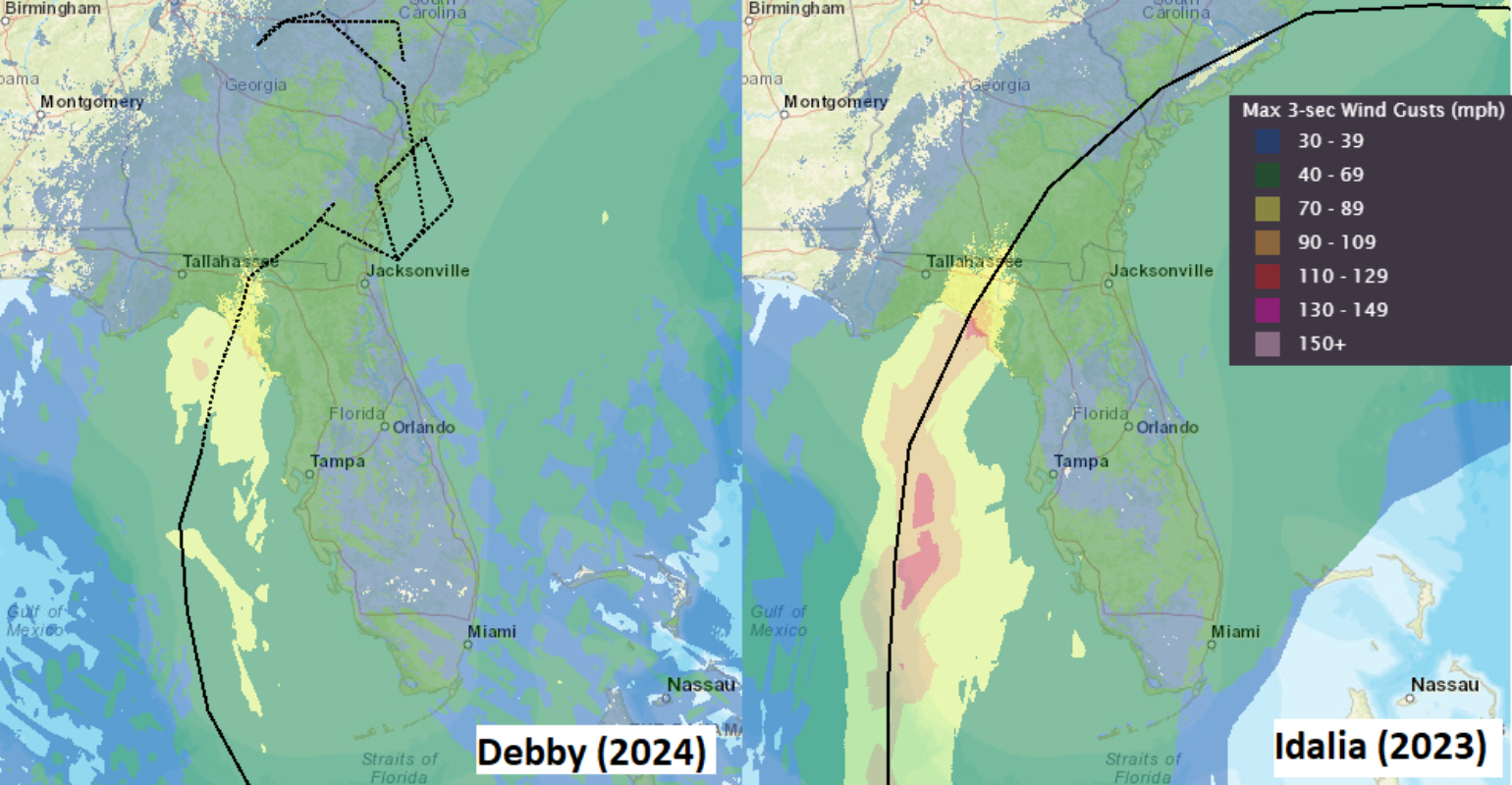
As the insurance industry looks to understand Debby's impacts, one might take the easy way out and cut and paste all the BMS Tropical Updates from Hurricane Idalia last year as they relate to Hurricane Debby and its impacts. Despite potential similarities, that cannot be done as the two systems have a few notable differences. Idalia can provide good insight into the impacts of the insurance industry as only 15 miles separate the landfall location around Steinhatchee, FL, as Debby made landfall with winds of 80 mph and a pressure of 979 mb around 7 am EDT.
Remember Idalia in hopes of understanding Debby's Impacts
Generally, our weather memory is short, but lucky, in this case, one does not have to remember too far back to understand what type of insurance industry impacts can occur as a result of Debby. First, remember that Idalia is the lowest insurance industry loss on record for its overall landfall intensity. These insurance loss predictions range from the Florida Office of Insurance regulation estimate of $300M to other industries' losses for Florida, which are a bit higher at just over $500M, with a total industry loss of under a billion dollars across the Southeast states. This is impressively low for a major hurricane landfall on the U.S. coastline. Regarding economics, the NOAA billion-dollar disaster estimate stands at $3.6B. This overall low level of loss for a 125 mph, 947 mb central pressure landfall major hurricane was essentially a result of the very low population density in the Big Bend region of Florida, and overall, the insurance take-up rate was lower in these relatively poor counties in the Big Bend region of Florida.
Similar to Idalia, Debby's track up the west coast of Florida has provided images of coastal flooding. Still, according to the NFIP, Idalia's 5,210 claims paid out a total of $364M. This is mainly because flood insurance is essentially non-existent in the Big Bend region, with the typical take-up rate likely below 5% and many inland counties less than 1%. However, as experienced with Idalia, Debby has provided some coastal flooding into the Tampa Bay and Naples area. A similar storm surge is anticipated along the coastal counties of Florida's Big Bend Region due to the area's unique bathymetry. The coastline's gradual shallow incline amplifies the impacts of storm surge, causing water to pile up when combined with the onshore flow driven by the counter-clockwise rotation of Debby's wind field.
Debby’s Wind Impacts
Debby and Idalia are different when it comes to the structure of the wind field. Idalia, at landfall, was a major hurricane and had a well-defined eye with a radius of maximum winds of 12 miles. Debby, on the other hand, is much weaker with a wider radius of maximum winds of 26 miles. Overall, the wind field is not as strong with a lower maximum wind speed. We also must remember that Debby is impacting a very desolate area of the Florida Gulf Coast, which is primarily dominated by wildlife areas. Now, just like with Idalia, some of Debby's outer bands did impact the Tampa Bay region, but again, these winds are very well managed for the building codes that are enforced in the area, and Idalia winds were much stronger along the coastline in the Tampa Bay area. As of now, with Debby, the wind gust was only 51 mph at Tampa International Airport, whereas Idalia had 61 mph. Observations from some storm chasers in Debby's eye suggest that the impacts are less significant than those of Idalia. Still, some propose that this is a similar repeat to Idalia's.
Overall, the wind impacts from Debby are expected to be manageable for the insurance industry, as any significant damage would have likely occurred during Idalia due to its greater intensity. And if a building was damaged, let us hope it was rebuilt better. Any new damage would likely be subject to high deductibles, a retained loss for many policyholders, and clearly not a reinsurance event for the overall insurance industry.
Another way to understand the overall impact of Debby is by looking at power outages. As Debby moves inland, PowerOutage.US will provide a resource to show the number of customers without power. As of landfall this morning at 10 AM EDT, 300K customers in Florida are without power. During Idalia, about 280K customers were without power after landfall, so overall, it was similar. Of course, one of the more populated areas near Debby's landfall location is Tallahassee, about 70 miles southeast of Debby's landfall location. It is far enough northwest of the Debby track to limit major damage to the state capital, which is prone to treefall damage and power outages as experienced through past named storms.

Lastly, the Big Bend region of Florida is no stranger to landfalling hurricanes. In fact, Hurricane Hermine, which broke the record 10-year landfall drought for Florida in 2016, only resulted in a $140M loss for the state of Florida. Interestingly enough, Debby has a similar presentation to Hermine. Another recent hurricane to take a similar track was Hurricane Elsa in 2021, which made landfall as a tropical storm in the Big Bend region of Florida with a Florida insurance industry loss of less than $120M. In general, Debby's insurance industry losses should be below Idalia's losses for the state of Florida. It is too early to determine insurance industry losses outside of Florida at this time.
Debby Storm Surge and Florida Flooding Impacts
Similar to Idalia, hurricane Debby's passage has caused plenty of coastal flooding along the west coast of Florida. One method to understand overall storm surge impacts is by looking at the Integrated Kinetic Energy (IKE) of a named storm. RMS HWind provides such a measurement, and yesterday, the IKE value was estimated at 14 terajoules. In contrast, before landfall, Idalia had an IKE value of 22 terajoules, so Idalia had a bit more energy in terms of wind and storm surge potential impacts. In general, storm surge is expected to be about 6 to 10 ft of inundation above ground level from the Suwannee River to the Ochlockonee River, FL. However, remember that this is a very remote section of the Florida Gulf Coast with limited exposure along the coastline that would experience such storm surge. Just like with Idalia, the worst of the storm surge will occur in areas like Steinhatchee, FL, and Horseshoe Beach, FL. Cedar Key, FL. In fact, the storm surge looks like it topped out at about 6 feet, and during Idalia, the storm surge was just over 7 feet. Storm chasers have also observed that the storm surge from Idalia in Steinhatchee, FL was not as great as it was in Idalia.
Rainfall from Debby should also be manageable, but some areas of rain will be impressive. For example, yesterday, Sarasota experienced its third-largest rainfall in recorded history, with about 9.5 inches of rain. During Idalia, there was only about 4.11 inches of rainfall. Therefore, one of the biggest differences with Debby right now is the rainfall, likely due to its slower forward speed. The rainfall will continue to be a huge issue for the Southeast U.S. in the coming days.
Debby’s Future Track
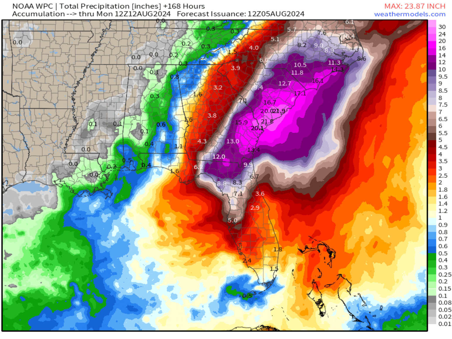
As we have seen with several named storms in recent years, water is the new wind, and it appears Debby will be known for its record rainfall that will likely occur across the Southeast as it slows inland. As Hurricane Debby moves inland, the threat of extreme rainfall and flooding increases. Northeast Florida, including Jacksonville into South Carolina, will likely experience upwards of 10-20 inches of rain or even more along the coast of the southeast U.S. Some forecast models suggest that localized amounts of 30 inches of rainfall could occur depending on what happens with Debby’s track and if stalls for a few days along the Southeast coastline.

Some models suggest that South Carolina could see a new state rainfall record from Debby, which would have to top 23.68 inches that occurred from Hurricane Florence in 2018. Three of the worst floods in South Carolina history occurred in 2015, 2016 (Matthew) and 2018 (Florence). There is a potential that storm surge could also be a problem along the Southeast coast if Debby moves back over the open waters off the Southeast coast. Areas like Charleston, SC, are very prone to storm surges, and if Debby moves offshore with prolonged onshore winds, it could create significant flooding for that historic city.

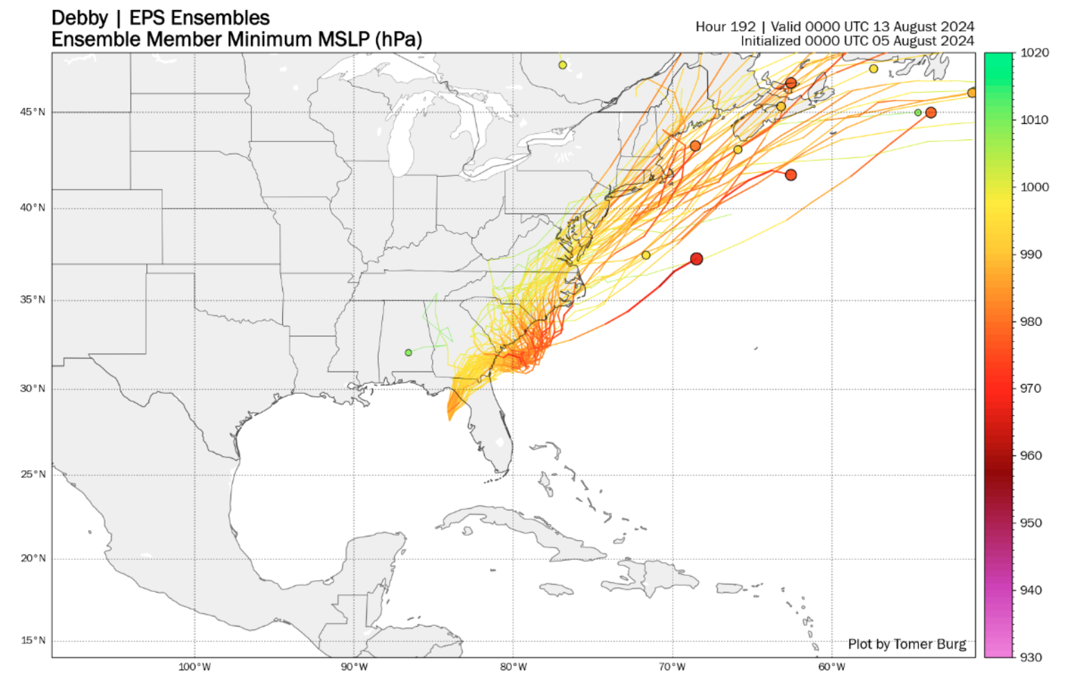
Given the significant forecast uncertainty over the next day, illustrated by the NHC Cone of Uncertainty expanding over the Southeast U.S. in the next five days, the insurance industry should be concerned about the potential for Debby to move offshore. If Debby moves out to sea, it could intensify and potentially turn back north, resulting in a second, possibly stronger landfall than the initial one in Florida. If Debby stays over land, it will likely weaken but could lead to increased rainfall. The forecast models, however, are highly variable. This BMS Tropical update leans towards the ECMWF model, which suggests Debby will eventually move northeast after causing significant flooding in the Carolinas. The stronger trough of low pressure impacting the Upper Midwest is trending towards allowing Debby to escape to the northeast, rather than stalling over the Deep South for several days.
Looking beyond Debby, the Atlantic is expected to become increasingly active in the coming weeks as the MJO moves into Africa. Forecasts indicate lower wind shear and gradually increasing moisture. Several waves are already present, and they warrant close monitoring—there is likely more activity on the horizon. As mentioned, the season is just getting started.
