

November Is Still Part of the Hurricane Season for a Reason
The impacts of Nicole are already beginning along Florida’s East Coast as it approaches. At the same time, the center is less than 24 hours away, but due to its large wind field and pressure gradient, impacts are already occurring with some minor power outages. It is already creating rough surf and low-end tropical storm-force winds along the Florida coastline. Over the last 24 hours, Nicole’s structure has evolved, indicating that a bit more intensification is likely before landfall. Nicole even shaded its subtropical designation on Tuesday morning and is a tropical storm with maximum sustained winds of 70 mph. Remember, a hurricane status occurs at 74 mph, so Nicole is already very close to this intensity. The biggest impact over the last 24 hours is likely the change in the development of an inner core of deep convection, which is impressively wrapping around the center of circulation. This is indicative of further strengthening in the near future. Nicole almost has an eye-like feature within the Bahamas radar network.
One thing that has not changed is Nicole’s massive broad circulation, these more intense storms are allowing Nicole’s strongest winds to both increase and shift closer to the center. The NHC and most forecast model guidance are still at a low-end Category 1 hurricane at landfall. However, do not let your guard down, as Nicole still has to pass over some of the warm gulf stream water. Although with that being said, wind shear and dry air could still be limiting factors. Unlike yesterday, there is less indication of a more robust Category 1 or even 2 at landfall, which is good news for the insurance industry impacts.
Nicole Wind Impacts
There is no doubt that a November East Coast landfalling hurricane is a bizarre event, which was highlighted with a dig into the climatology in yesterday’s BMS Tropical Update. However, we forget that the hurricane season goes to the end of November for a reason. What likely should be more impressive is that the last hurricane landfall to occur along the Florida East Coast was back in 2005 with Hurricane Katrina, which was in southern Florida. 2004 Hurricane France and Jeanne made landfall right around where Nicole is expected to make landfall near Port Saint Lucie, FL, which might help lower some of the loss around the landfall location. However, the Insurance Institute for Business and Home Safety (IBHS) just did a study on the impacts of Hurricane Laura (2020) and the new roofs that had been installed after Hurricane Rita (2005). They evaluated the performance of the roofing materials and found that asphalt shingles, regardless of their wind rating, have a high probability of damage once they eclipse ten years of age when subjected to wind gusts typical of Category 2. This could be an excellent opportunity to study the impacts of even older roofs on Category 1 winds. Sure, some resiliency might be in the built environment near the landfall location due to the 2004 storms, but any new roof upgraded since 2004 is close to being considered old, according to the IBHS research.
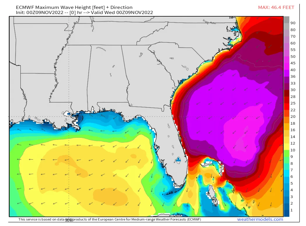
As discussed in yesterday’s tropical update, the most significant impact will be Nicole’s size. Nicole has a vast wind field, and tropical storm force winds will extend well beyond what might be considered a normal range. To illustrate how large the wind swath is, take a look at the BMS iVision wind swath that shows the extent of tropical storm force 1 min wind speed, which extends 270 miles to the north of Nicole’s track. BMS iVision suggests that before landfall, Nicole should have a radius of maximum winds of 47 miles from the center and a forward speed of 16 mph.

Now keep in mind that the gust wind speeds will have an even larger extent.

One of the significant points made yesterday is that named storm claims can happen even in the weakest winds across Florida. Power outages are already starting to occur in some coastal counties. What drives loss from a named storm can be complicated. With the protection gap growing due to higher deductibles across the state, will the damage be enough to file a claim? Due to Hurricane Ian’s rainfall, soil moisture is running above normal. Wetter soil will increase treefall in higher winds; maybe it is other issues like damage to pool enclosures, which can easily happen in lower wind speeds, or perhaps it is just the litigious nature of the Florida insurance market. There is not a good recent analog named storm to go off of to help with the insurance loss estimate, given the lack of named storm landfalls making landfall on the East Coast of Florida since 2005. Given the large swath of tropical storm force winds and the wind-driven rain that is expected far away from the center of the storm, claims could occur over a wider area as this does not appear to be a normal Category 1 type of landfall. This might also complicate some of the catastrophe modeling event set selection as there could be difficulty in finding similar events with such a large wind swath. Regardless, this will continue to be a manageable event. Still, likely a painful event for insurance carriers as losses might not be high enough to reach higher attachment points within cat programs, which might be suitable for reinsurance companies and overall capacity issues within the marketplace.
One risk that is not often discussed with named storm landfall is the occurrence of tornadoes. It is not out of the question that a slight risk of tornadoes is associated with outer bands of Nicole, particularly in east central and northeast Florida Wednesday afternoon through Thursday morning. While a major tornado outbreak is not anticipated, rainband tornadoes spin up quickly. Recently Ian crossing Florida resulted in 70 tornado warnings and 11 confirmed tornadoes. Often these are isolated touchdowns and are often weaker (EF 0 – EF 1), short-lived in nature and are typically not a source of major insurance industry loss.
Nicole Storm Surge Impacts
Coastal flooding and surge along Florida’s East Coast continue to be the primary concern from Nicole. With several days’ worth of north-easterly and easterly fetch through Thursday, combined with a full moon that will aid in the higher-than-usual tides, comes significant and long-lasting inundation of low-lying areas near the Atlantic coast and St. Johns River system.
Storm surge will occur along a large part of the southeast U.S. coastline, with the highest storm surge occurring where the Storm Surge Warnings are up for most of Florida’s East Coast and coastal Georgia. In this region, peak surge over average high tide is expected to be 3 to 5 feet, perhaps higher.
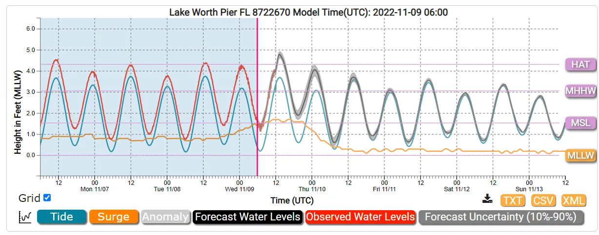
The plot above shows the mean low water level for Lake Worth Pier, FL, reaching a height of 5 feet. The NOAA Probabilistic Extra-Tropical Storm Surge product is a great resource for getting detailed storm surge impacts and how they relate to tide cycles.
Nicole Rainfall Impacts
The heaviest rainfall totals of 3-6” with a local maximum of 8” are expected across the eastern half of the peninsula, where the highest risks of urban flooding and river flooding issues reside. A general 2-4” is forecasted for west-central and north-central Florida.
Summary of Impacts
There is still some uncertainty in the exact landfall location. But do not let that fool you as impacts, given that the large wind field, will be far away from the center.
Given the large wind field, claims could occur across a broader area that is atypical for a normal size Category 1 hurricane.
Storm surge will occur along a large section of the East Coast of Florida.
Impacts beyond the state of Florida will be minor


