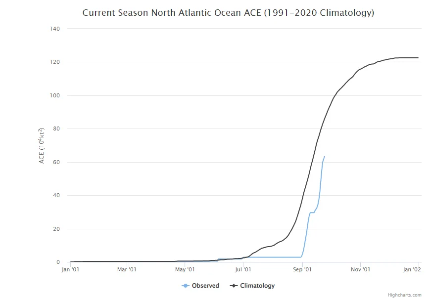
After leaving the African coastline 11 days ago as a tropical wave, with much anticipation, early this morning, Ian has become the 4th hurricane of the 2022 Atlantic season with winds of 75 mph. According to Phil Klotzbach at Colorado State University, only six other years since 1990 have had four plus Atlantic hurricanes form between September 2nd – 26th, showing how quickly the season went from record low activity to near normal activity in terms of Accumulated Cyclone Energy (ACE).
With Ian now designated as a hurricane, the satellite and radar data from Grand Cayman are starting to show a bona fide eye. Hurricane Ian is now on its way to the anticipated rapid intensification of a major hurricane. In fact, within 48 hours, Ian is expected to be a major Category 4 with winds of 140 mph as Ian traverses ocean heat content values that are at the top of the scale and can easily support a major Category 5 hurricane. As BMS Re suggested in this TradingRisk.com article on July 8.
Ian Core Size and Strength Key to ImpactsThese BMS Tropical updates have focused on two possible scenarios for the last several days. Unfortunately, there is still significant uncertainty in Ian’s track, especially in the three to five-day timeframe as it tracks toward the Florida coastline. The two scenarios discussed yesterday, including the GFS with its path towards Apalachee Bay and the ECMWF with its track towards Tampa Bay, have not changed much in the last 24 hours. The National Hurricane Center track continues to follow the multi-model consensus. The factor in these two scenarios is that as Ian tracks to the north, it will start to slow and encounter the wind shear and dry air, which should weaken Ian. What might be critical is the overall structure of Ian after it crosses Cuba late tonight.
The hurricane hunter aircraft data suggests Ian is building a small core. But the question remains: will Ian have a small core after landfall with Cuba, like Charley (2004) - causing a limit to the overall size of the hurricane and limit storm surge impacts? Or will the land disrupt Ian’s core allowing it to expand into an enormous hurricane that could increase the storm surge impacts? This detail is critical when considering the forecasted track of Ian. Storm surge is becoming a significant concern given the track towards Tampa Bay.
In the previously described scenarios, dry air and wind shear will increase. Therefore, the intensity of Ian in the Gulf of Mexico is critical to its impacts north as the dry air and shear will weaken Ian. Still, the weakening will be a function of how strong Ian is to begin with.
In both scenarios, the decline is expected to slow the forward speed of Ian as it approaches the Florida coastline, which amplifies the impacts of storm surge and heavy rainfall.

BMS iVision above that uses the Verisk Respond product continues to show a track just enough offshore to limit some significant impacts to the Tampa Bay Area. It also shows the rapid weakening and slowing as Ian tracks north. This is just one model scenario. The ECMWF model is much closer to landfall near Tampa Bay, resulting in a completely different loss outcome than the BMS iVision respond product suggests.
Water Is the New Wind
To date, these BMS tropical updates have been focused on the track and category, but it might be time to focus on something else. It is a given that Ian will be tracking very close to the west coast of Florida with either a landfall along the west central coastline or near the Apalachee Bay area. What also seems to be a given is that Ian will be a classic case of how the impacts might not match the overall category. The wind impacts will be determined by the size of the radius of maximum winds and the extent of the wind field along Ian’s track.
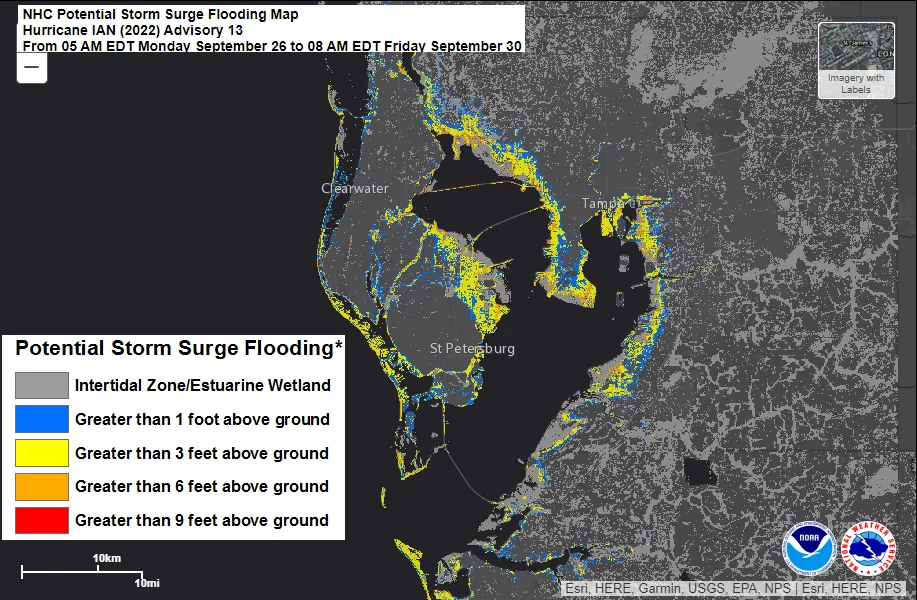
This size also impacts the storm surge. Remember Hurricane Ike (2008) was only a Category 2 at landfall in Galveston, but it had impacts of Category 4 along the Bolivar Peninsula to the north. The west coast of Florida has a very gentle slope to the sea floor, making it very susceptible to storm surge. As Ian slows, the onshore wind will pile water up along the Florida coastline, so even if the GFS scenarios are correct with strong winds staying offshore, the storm surge could still be a significant issue. Even if Ian weakens the ocean can maintain the energy for a few days. This will particularly be an issue as the water gets forced into Tampa Bay. Interestingly, if Ian makes landfall south of Tampa Bay (lower probability at this time), it could draw water out of Tampa Bay, resulting in record low water levels.
For 101 years, Tampa Bay has largely avoided the core of the most notable hurricanes. These tropical updates have already made mention of the 1921 Tarpon Spring Hurricane and the expected insured loss that the storm could cause the insurance industry ($15 - $25B). According to Cary Mock, a professor at the University of South Carolina who studies historical hurricane impacts via ship logs, the storm surge from this event was about 10.5 – 11 feet. Another historical hurricane to impact the area was in 1842 and had an even larger storm surge of 20 feet. These historical events show that Tampa Bay is very prone to storm surge, given the perfect orientation of the storm track and the size of the storm.
The NHC will be providing detailed storm surge forecasts as Ian approaches Florida. Currently, many areas in Tampa Bay will already be under three feet of water with as much as six feet in some localized areas.
The other factor becoming increasingly apparent is that a significantly prolonged rain event is possible with a slowed forward motion towards the Florida coastline. Suppose the storm’s center tracks closer to the west coast or makes landfall. The heaviest rain could dump as much as 20 inches. Given these scenarios, major inland flooding is also very possible. So regardless of the category Ian is as it nears or bypasses the west coast of Florida, storm surge and rain could be a significant problem.

When it comes to flooding and storm surge losses, the question is how much is covered by insurance? According to some older data released by the Wharton School of Risk Management based on 2018, take-up rates are only 21% - 40%. However, given the revision in the National Flood Insurance Program, it appears that hundreds of thousands are dropping flood insurance as rates rise.
Bottom-line:
Hurricane Ian is on its way to becoming a major hurricane and could be a Category 3 hurricane as early as tonight, impacting the western tip of Cuba.
There are still multiple scenarios for Ian and its projected impacts on the Florida Coastline.
Ian’s track and intensity are essential, but inland flooding and storm surge impacts might not depend on Ian’s overall intensity and track.
Tampa Bay is very susceptible to storm surge, and historical storms that have taken a similar track to what is forecasted by the ECMWF show just how severe the flooding could be.
Expect a wide range of potential losses given the uncertainty in the track of Ian and the built environment it may or may not impact.