

Early this morning, the National Hurricane Center (NHC) upgraded Invest 98L into TD9. Fiona has passed Bermuda with high-end tropical storm force winds, with the airport receiving a gust of 93 mph with sustained winds of 61 mph. The island really dodged a bullet here as the storm had record low pressure values for a storm passing Bermuda. Fiona's impacts on Nova Scotia and the Cape Breton area will be also historic, as highlighted in yesterday's tropical update. The only real change in Fiona's impact is that the storm will be moving faster over the region than initially anticipated, but this will have little impact on the result of this historic storm for the area.
While Fiona will cause widespread insured loss, as highlighted, the area generally has a low population. This contrasts with the possible impacts that TD9 might have, which is a good reason why the insurance industry, particularly Florida insurance carriers, now have their eyes on TD9.
Will Florida Peninsula Hurricane Luck run out?
It might not seem like it but, given how active the last several hurricane seasons have been, the Florida Peninsula has been pretty lucky regarding direct hurricane impacts. A hurricane has not made landfall on the Peninsula since Irma in 2017. Therefore, it has been five years since any landfall, which is pretty remarkable given both the overall activity experienced since 2017 and that the peninsula has the highest chances of landfall probability in the U.S. This follows the even longer hurricane-free streak that occurred between 2006 and 2015 for the state of Florida, which, as mentioned in the Tropical Update yesterday, ended with Hurricane Hermine (2016). The state’s panhandle has not been so lucky since 2016, with many significant hits recently, including Category 5 Michael (2018) and Sally (2020). The peninsula has had some very close calls, most notably Dorian (2019) that stalled over the Bahamas before tracking up the Florida coastline. Other bypassing storms include Matthew (2016) and Elsa (2021) along the west coast.

TD9 Forecast Track
TD9 seems to be developing a bit sooner than forecast models suggest, with the system likely becoming a named storm later today. The next named storm on the list is Hermine followed by Ian. It will be a race to see what name gets assigned since TD10 has formed off the African Coastline this morning as well. As mentioned yesterday, the sooner Invest 98L develops, the sooner it will likely curve to the North vs a weaker system tracking further West. Since the TD9 seems to be developing sooner, the threat of TD9 approaching Western Cuba and entering the Southwestern Gulf of Mexico by early next week is a much more realistic scenario. However, there is still a lot of uncertainty in the intensity and track. The system’s strength and intensity before it interacts with Cuba will be critical to what type of system impacts Florida. Remember, the NHC forecast is one of the best-skilled forecasts. However, still, a five-day forecast like the one shown today that ends with the last forecast point over South Florida has an average error of 200 miles, and with the models doing so much flip-flopping, do not be surprised if the NHC track over the next five days continues to adjust.
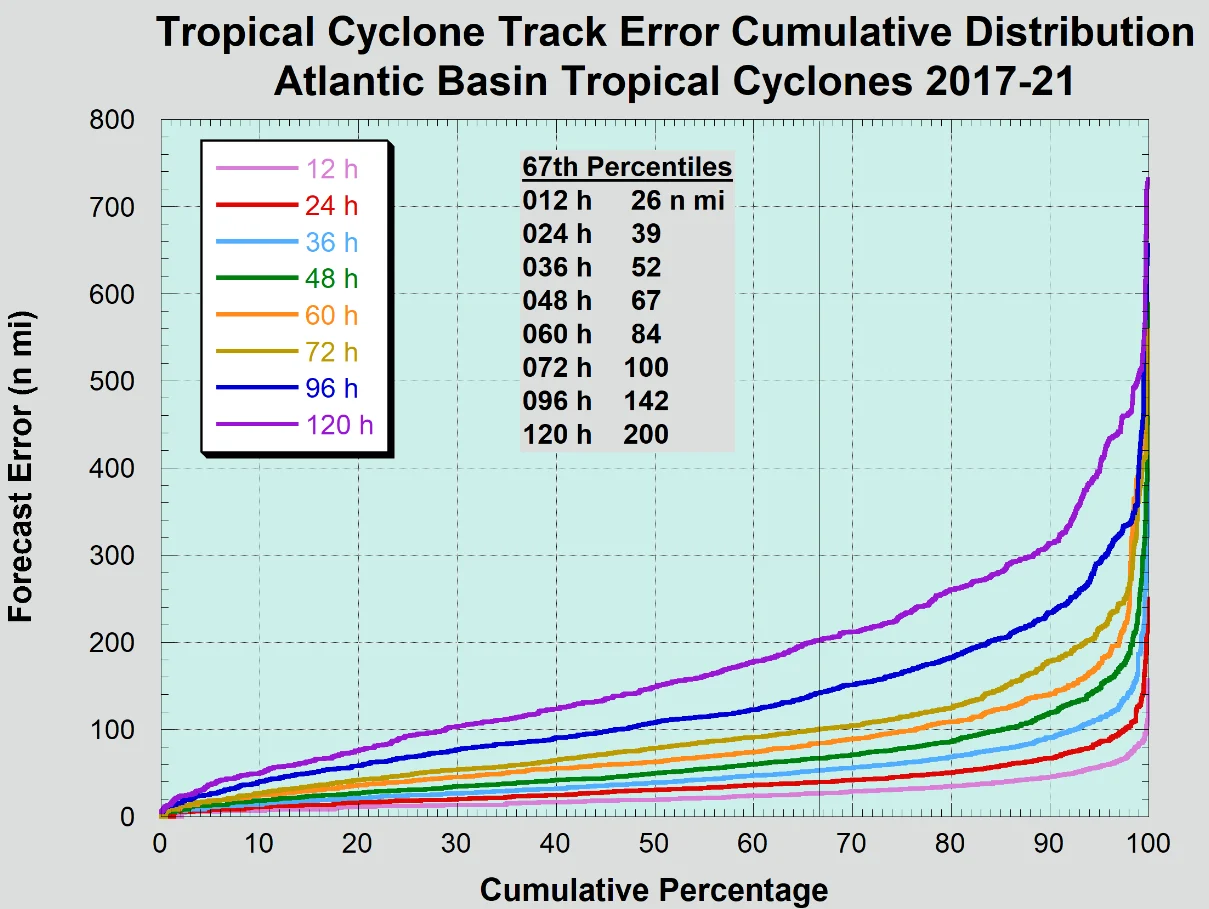
TD9 has gotten a lot of armchair meteorologist attention this week. It has hopefully been a great lesson in understanding forecast uncertainty. If anyone told you they knew where Invest 98L would go, they did not know and still do not know. This is why it is important to use ensembles, as we have been shown to have the best ideas of possible outcomes. Below is just an example of the GFS forecast track errors for TD9 over the last six forecasts since the evening forecast Wednesday, September 23rd.

The GFS had significant errors because it was not taking into account an upper-level low that is likely to develop this weekend to the northwest of the TD9. This will likely offer a sharper turn of the system towards Cuba. Now, how sharp this turn has yet to be determined and will result in many different forecast scenarios. Still, the overall target now appears to be south Florida vs. the rest of the Gulf Coast states, which the GFS model was suggesting all week - with the ECMWF model being a bit more consistent in the idea of a Florida impact.

Given the overall uncertainty in the turn north, there is still a chance TD9 could track up the west coast of Florida to the eastern panhandle or miss Florida altogether. Of course, this will have track implications as to what impacts might occur up the east coastline for insurance carriers. There are countless analogs of storms crossing south Florida and running up the East Coast like Donna (1960).
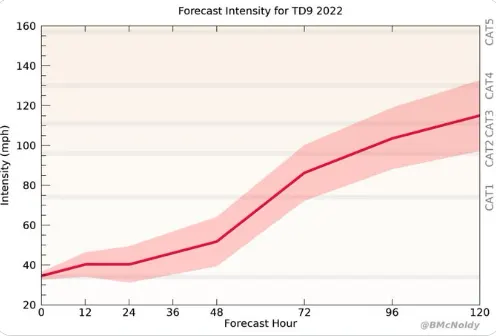
TD9 Intensity Forecast
With TD9 being classified by the NHC, there will be a better forecast guidance and data collection, starting with a flight from the hurricane hunter aircraft. This will investigate the current structure and intensity, all of which should feed into the various forecast model providing better guidance.
As mentioned previously, the intensity forecast will depend on the track forecast and how much land interaction it might have with Jamaica and Cuba. In the tropical update, we highlighted how the overall environmental conditions should be prime for rapid intensification under ideal conditions and some of the warmest water in the Atlantic basin; a robust upward bias is possible in the current model guidance. Of course, land interaction in western Cuba is often not as detrimental to intensity as the storms that track the central or eastern part of the country. Any land interaction should weaken the storm and could limit impacts. However, there are also a handful of storms, like Irma (2017), that interacted with Cuba, yet still made landfall in South Florida as a major hurricane. We also cannot forget hurricane Charley (2004), which is a good analog track, which crossed western Cuba and quickly intensified. There is reasonable guidance to suggest rapid intensification can still occur along the track of TD9.

It also might be surprising that the earliest reasonable arrival time for winds over 40 mph could be as soon as Monday evening. Of course, any intensity of a storm moving up the East Coast and those impacts are all dependent on what happens over the next 48 – 72 hours in the initial development and turn north.
Bottomline:
If it passes over central Cuba, it will have less time to intensify before reaching Florida.
If it heads into Gulf or western Cuba, a more intense storm is favored.
Do not forget there is as much as a 200-mile forecast error at this point with a 5-day forecast, but following the ensemble mean, and the National Hurricane Center track forecast is likely the best guidance.
Rapid intensification is very likely given the ideal environment, regardless of overall track.
It is not often the NHC explicitly forecast rapid intensification. They are calling for this with TD9


