

A quick look at the National Hurricane Center seasonal activity chart and the current activity map shows several areas of activity are occurring. However, this should come as no surprise as we are just over a week removed from the peak of the Atlantic hurricane season. The historically low activity level for the first part of the season might make this a bit unusual.
Since the last BMS Tropical update, Fiona is still the main story - although Gaston has also formed in the Northeast Atlantic. Further, as discussed at the end of that tropical update, the area that is moving across the Southern Caribbean off the coast of South America is still expected to develop in the Central or Western Caribbean in the next two to four days.
Hurricane Fiona
As expected, Fiona has grown to a major power hurricane and is currently a Category 4 hurricane that will be tracking just to the west of Bermuda. At this time, impacts to Bermuda should be limited. Fiona will be tracking just far enough so Bermuda only experiences tropical storm force or low Category 1 winds. However, waves and storm surge could still be a factor for the island as Fiona will continue to grow in size and the intensity fluctuates on its track northward. Still, overall, the island is no stranger to hurricanes and can surely handle the impacts of Fiona.
On its way past Bermuda, Fiona’s most significant impact will likely come to Nova Scotia, Canada. These will occur as Fiona transitions to an extremely powerful non-tropical storm prior to landfall this weekend over Atlantic Canada. This is similar to the type of system Hurricane Sandy was when it impacted the Northeast U.S. in 2012. However, Fiona will be much more powerful than Sandy. Some forecast models are showing a pressure down to 927 mb. To put this into perspective, the current all-time Canadian low-pressure record (on land) is 945.1 mb, set at St. Anthony, Newfoundland (January 21, 1977). With this type of pressure, significant wind and surge damage should be expected, particularly across Cape Breton, Nova Scotia.
The other issue is that the storm will slow upon landfall and maybe even stall across the Gulf of St. Lawrence. As a result, prolonged winds and rain will increase the threshold for damage and power outages. Unlike other intense winter storms that often impact the area, the other compounding factor is still plenty of foliage to stress trees, making tree fall another significant factor.
If there is a good side, it would appear the post-tropical storm will track to the East of Halifax, which has seen considerable growth in population and housing in the last several years. Halifax has 46% of the province’s population, and Cape Breton has seen little to no growth. There was only an increase of nine people living on the island from 132,010 in 2016 to 132,019 in 2021. The housing stock across Cape Breton is older, but generally well built due to the frequent intense winter storms and hurricanes that impact the area. Eastern Canada has had several hurricanes since the last New England Hurricane Bob in 1991. Fiona, however, will not be like these other storms. The best scenario would be for Fiona to track east up the Cabot Strait and have more of an impact on Newfoundland, which is even less populated than the Nova Scotia half.

Western Caribbean (Invest 98L)
The area discussed in the last tropical update is still expected to develop into a depression or tropical storm within the next 46 to 72 hours. This will be key to what happens in the future with this tropical system. If the storm develops faster, it has a better chance of getting pulled up quickly into Cuba and will have less impact on the U.S. insurance industry. If it develops slowly, it has a chance to make it further west, which is not a good scenario for the U.S. insurance industry. There is also a possibility that nothing develops, but given the forecast support, this outcome is fairly low at this time.
Currently, the tropical wave looks pathetic, but there are two reasons why this should have the attention of the insurance industry. The first is the overall environment that Invest 98L will move into the western Caribbean late this weekend and early next week is much more favorable for development. As Invest 98L likely passes somewhere between Jamaica and Honduras, shear will drop below 10 knots, mid-level moisture will increase, and the disturbance will be crossing waters with some of the highest oceanic heat content in the Atlantic basin.
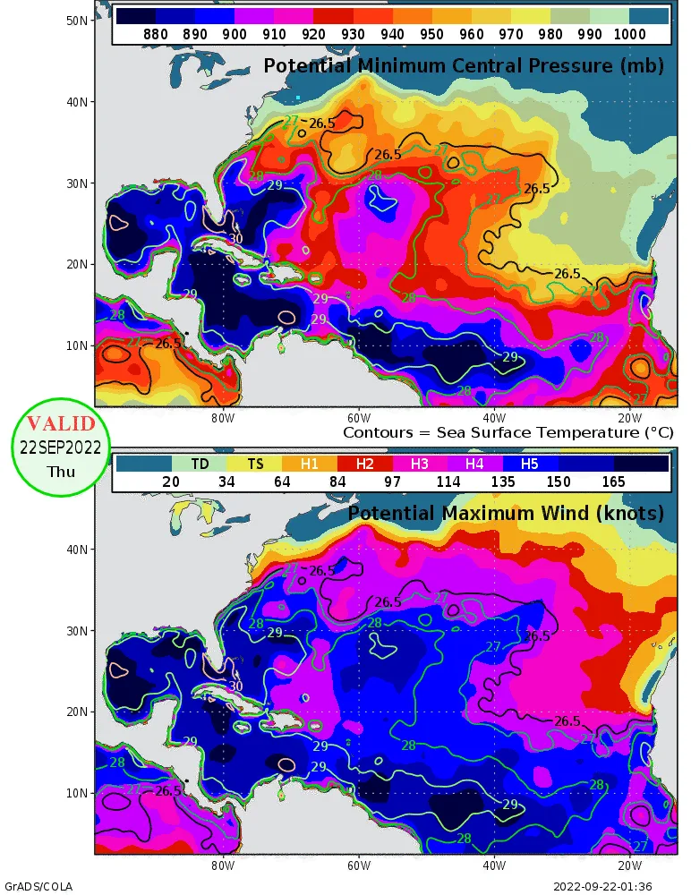
The second very concerning factor is that an anti-cyclone will develop at the upper parts of the atmosphere above the tropical convection. Developing storms feed off this type of upper airflow as it aids the storm’s outflow, often providing that fan shape one might see on a satellite image of a powerful hurricane. This upper-air pattern, along with the very warm water and low wind shear, sets up the potential rapid intensification in the western Caribbean.
Besides the uncertainty of how fast Invest 98L develops, there is a bit of uncertainty in the overall steering wind later next week. Model guidance suggests a deep dip in the jet stream over the eastern U.S. The uncertainty of this trough of low pressure depends on what happens with Fiona; but, this means that steering winds over the northwestern Caribbean in 5 to 7 days will turn more south-to-north rather than east-to-west. If Invest 98L is far enough north to feel the influence of the trough, which again has a lot of uncertainty, it would get sucked north into the Gulf of Mexico or Straits of Florida later next week.
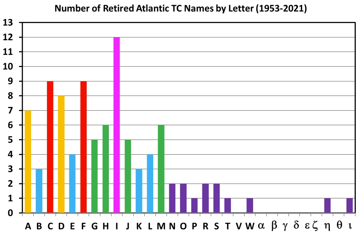
The next named storm on the North Atlantic named storm list is Hermine. It is unclear if the system off the African Coast or Invest 98L will get the name, Hermine. The next name after that is Ian. The concerning aspect of this is that the “I” storm has been retired 12 times since 1954, most recently with Ida in 2021. “I” storms do not treat the insurance industry well. What happens if Hermine gets named out of Invest 98L? Do you remember the last time hurricane Hermine came around in 2016 and caused the insurance industry a $250M loss? Hermine caused a good amount of damage when it made landfall as a Category 1 in the Apalachee Bay area. Given the current forecast from some models, one has to wonder if history will repeat itself - but this time having a run at possible retirement once and for all.
There are all types of possible scenarios on the table for Invest 98L. Still, the environmental conditions and bathtub water look suitable for some Invest 98L to become a named storm. There is a concern that any development will be rapid and a major hurricane could result. The question if this occurs is, where will it go? The super ensemble below provides some early hits. Right now, the entire gulf coast is under watch, and of course, the intensity will be determined by track and other land interactions, so it is too early to detail specific impacts. If you are a model watcher, watch the ensemble mean. Remember, Invest 98L is not even a storm and looks horrible currently on the satellite image, so it is a guessing game with little skill.


