73 days into the Atlantic Hurricane Season
We are now 73 days into the Atlantic Hurricane Season, and up to this point, there has been little to talk about. Hence, the limited BMS Tropical Updates via e-mail since our seasonal outlook was issued, as overall, there have been no hurricanes, and the four tropical storms have been short-lived prior to yesterday. However, that is all about to change with the development of Tropical Storm Erin yesterday in the Eastern Atlantic Basin, which this BMS Tropical Update will focus on.
Before we dive into the details of Erin, let's review the season to date. Tropical Storm Chantal was the only notable storm for the insurance industry, developing as a tropical depression east of Jacksonville, FL, on July 4th and strengthening about six hours before making U.S. landfall along the South Carolina coastline near Myrtle Beach. Tropical Storm Chantal resulted in an insurance loss of about $100 million. Chantal made landfall on July 6th with a pressure of 1002 mb and a wind gust of 56 mph at Springmaid Pier in Myrtle Beach. The rainfall caused the most significant problems for the insurance industry, with as much as four to six inches of rainfall leading to flooding. However, this flooding was overshadowed by the substantial amount of rain, flooding, and deaths in the Hill Country of Texas around the same time.
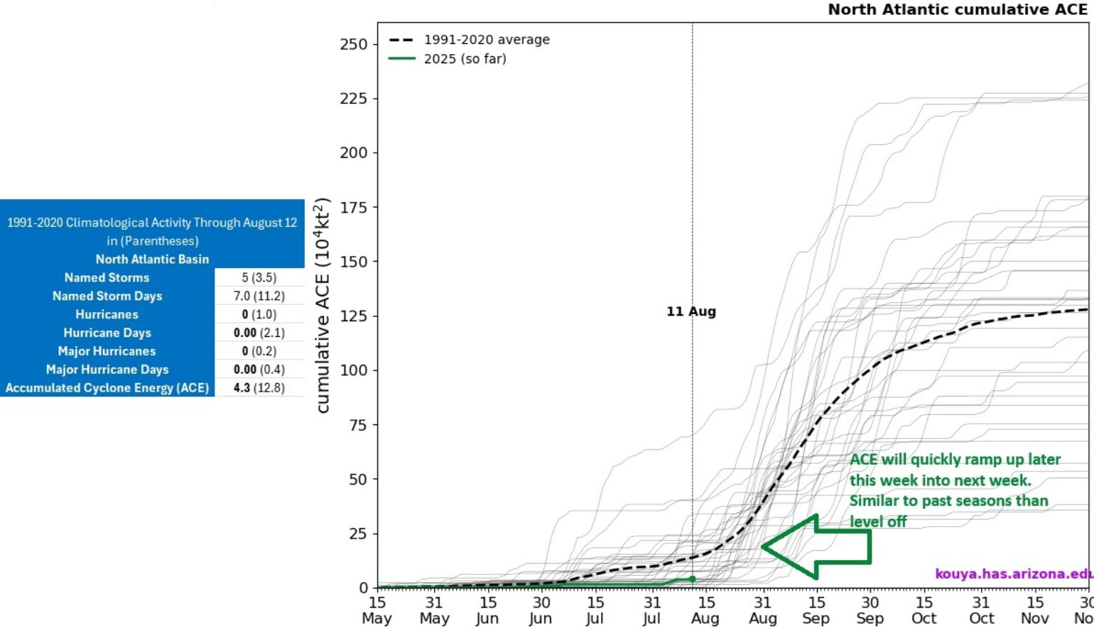
Below is a table and chart of the Atlantic Hurricane Season as of August 12 (averages in Parentheses). As mentioned, the four named storms before Erin have been relatively short-lived and weak, resulting in only 3.7 units of Accumulated Cyclone Energy (ACE).

By the end of next week, by all metrics in the table above, it will be well above normal year to date.
Based on the forecast for Erin’s long-lived track at high intensity, the ACE will quickly ramp up in the coming weeks with tropical activity. Like clockwork, this is happening right around when Dr. William Gray, one of the forefathers of tropical meteorology, would famously ring his bell every August 20 through the halls and research labs at Colorado State University to signal the start of the most active eight-week stretch of the hurricane season.
Tropical Storm Erin, which formed the morning of August 11, is the fifth named storm of the season and is expected to become the first hurricane of the season later tomorrow night (Wednesday, August 13), just a few days after the climatological date of the average first Atlantic Basin hurricane’s formation (August 11). Forecast models and the National Hurricane Center also suggest Erin will become the first major hurricane of the season by Sunday, August 17, which would be ahead of the climatological date of the first major hurricane, which is September 1.
Long range forecasting Erin track
With Tropical Storm Erin underway and currently about 1,765 miles away from the Northern Leeward Islands in the East Atlantic, Erin will be considered a long-tracking named storm over the next 10+ days, therefore, any meaningful impact forecast would be considered a long-range forecast, and now is a good time to remind the insurance industry about long-range tropical weather forecasting. The insurance industry needs to recognize that forecasting for periods of eight days or more for named storms is challenging. Weather models often have an error of about 300 miles on a 10-day forecast, so the cone track uncertainty is huge. For reference, the National Hurricane Center (NHC) cone of uncertainty on the five-day forecast is about 213 miles. The primary reason long-range forecast models exhibit significant error is that global forecast models for named storm forecasts often lack full resolution, and there is difficulty in modeling the full physics of cloud cluster occurrences and smaller atmospheric features that can have long-term impacts on future outcomes. The concept is called the “butterfly effect” - the flap of a butterfly's wings can, in theory, eventually cause a hurricane on the other side of the world.
Understanding Erin will be a long-term tracking system, with many forecasts to help us understand current skills and trends. This will be the focus of future BMS Tropical Updates as we build a repository of projections for Erin. Currently, the trend is shifting for Erin to track further west, and it's becoming a weaker system as it approaches warmer water.
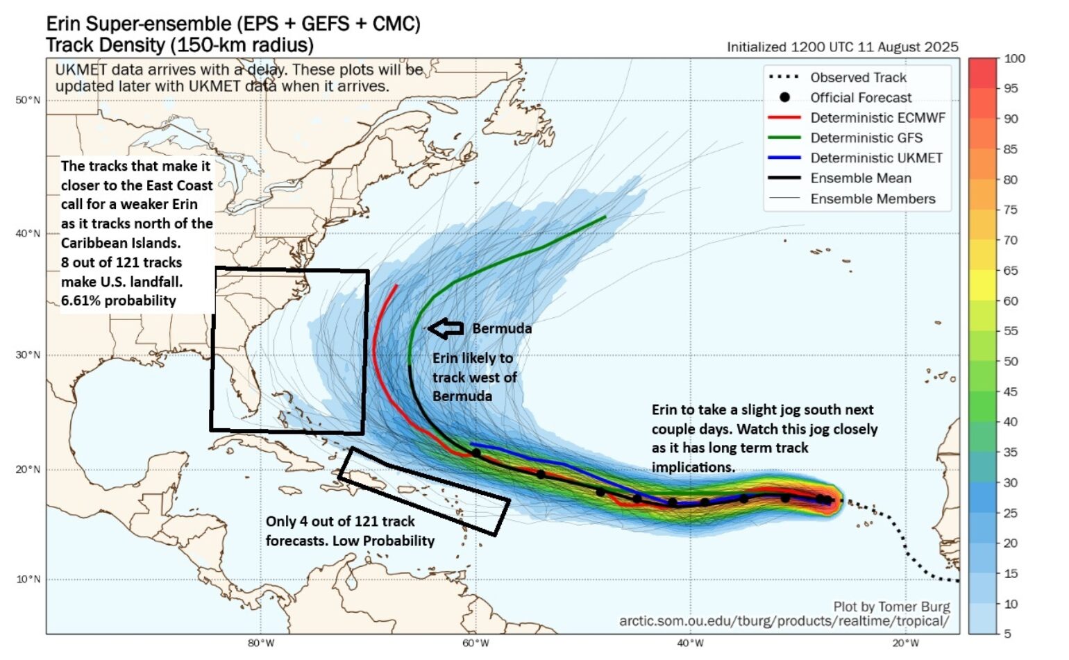
For better or worse, the insurance industry has hundreds of forecast model projections that can be used to track named storm development into the future. Often on social media, you will find a threatening solution posted for a major hurricane near the U.S. shoreline, like the American GFS model, which seems to add to the forecast uncertainty. If the insurance industry followed this model, it would have already had thirty-plus major hurricane U.S. landfalls this season, and we know that hasn’t happened. This model is not the best, and the BMS tropical updates place more weight on the trusted ECMWF or, with long-range forecasting, look at a super ensemble blend of 121 individual forecasts to understand track clustering, but also understanding that some models like the ECMWF that consistently outperform the American GFS model, making it more reliable. Using these ensemble forecasts to look beyond the 5-day cone of uncertainty forecast that the NHC issues is beneficial to understanding future impacts on the insurance industry. As in years past, Tomer Burg from the University of Oklahoma has provided a helpful tool set for looking at these various ensemble products. In the latest forecast for Named Storm Erin, we can use the Super Ensemble (121 individual forecasts) to get an idea of the track trend and where Erin will track beyond the five-day forecast and understand the current threat of a landfalling Hurricane on the U.S. Coastline.

The plot above shows that Erin will continue on a westward track with perhaps a slight southwest jog until about 50°W longitude as it travels the southern edge of the ridge of high pressure known as the Bermuda-Azore High. This jog southwest could be very important in the future track and intensity of Erin. A more southern track would be weaker, allowing Erin to track further west towards the islands and the U.S. East Coast. Around Thursday, Erin will start to track in a more northwest direction above the Caribbean islands. Right now, there is less than a 5% chance of Erin tracking near the Caribbean islands. The current suggestion is that Bermuda has the highest probability of seeing an impactful storm, with Erin likely tracking west of the island. However, this should not be a surprise, as our preseason forecast suggested Bermuda would be a target for this season. Bermuda has also had a string of impactful seasons, such as Ernesto 2024 just last season and Paulette in 2020, which is amazing for a 20-square-mile island in the large Atlantic Ocean. Of course, as one of the world's insurance hubs, the island is built to withstand hurricanes, having endured a long legacy of impacts; the nation has tight building codes that allow the small island nation to build for hurricane impacts. Hopefully, other parts of the insurance industry are taking note and see this type of resilience continue to take shape along the U.S. coastline.
At this time, it is too early to rule out any impacts to the U.S. East Coast, but right now the probability is likely below 6%. Still, in the plot above, one can imagine if the forecast were made for an even longer period of time, some of the current ensemble forecasts would provide a solution that could bring an impactful storm to the U.S East Coast, but again, the probability is low at this point in time.
Long range forecasting Erin's intensity
One thing that we did not discuss in the track forecast above is how intensity would also play a role in the potential track. The stronger Erin becomes, the higher the likelihood that Erin will recurve towards Bermuda. If Erin is weaker, it would take a more westward track toward the northern Caribbean islands and eventually the East Coast of the U.S, or recurve before the East Coast of the U.S. This means the intensity of Erin over the next few days likely holds the answers as to what happens with the future track.
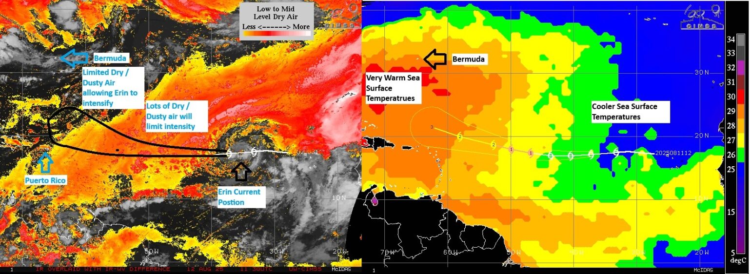
Over the next few days, Erin will struggle with intensity. There is a lot of dry/dusty air around Erin, as you can see from the image below. On top of this, the overall sea surface temperature (SST) environment is marginal at best. However, as Erin approaches 50°W longitude, the dry dusty air abates and the SST warms, and this allows Erin to strengthen. It is at this time that Erin could become a major hurricane. As mentioned in the track section, Erin is being steered by an elongated ridge of high pressure. In a few days, a weakness develops in the western part of the ridge, allowing Erin to turn north between higher pressure to the east and higher pressure centered across the Central U.S. It is at this time that Erin becomes a significant hurricane, adding to the seasonal ACE. Fueling Erin will be some of the warmest waters of the Atlantic Basin, which will only further intensify its strength in the long-range forecast, so don’t be surprised if Erin achieves Category 4 status or higher as it approaches the western part of the Atlantic basin near Bermuda or off the East Coast of the U.S.

At this point, it is too early to estimate any insurance impact on the U.S. Still, the insurance hub of Bermuda should be on guard, as this tiny island has the highest chance of impact and as the critical January 1 renewal season starts, there is a chance some underwriters might take shelter for a few days or leave the island, which is hopefully the only impact to the insurance industry at this time. It should be expected that after Thursday this week, we will have a much better idea of what Erin's endgame will be as we get better long-range model guidance and Erin starts to strengthen in a more ideal environment.
These BMS Tropical Updates will be updated as needed to keep the insurance industry informed of any impacts.
