By Andrew Siffert – Vice President / Senior Meteorologist
Yucatan Impacts
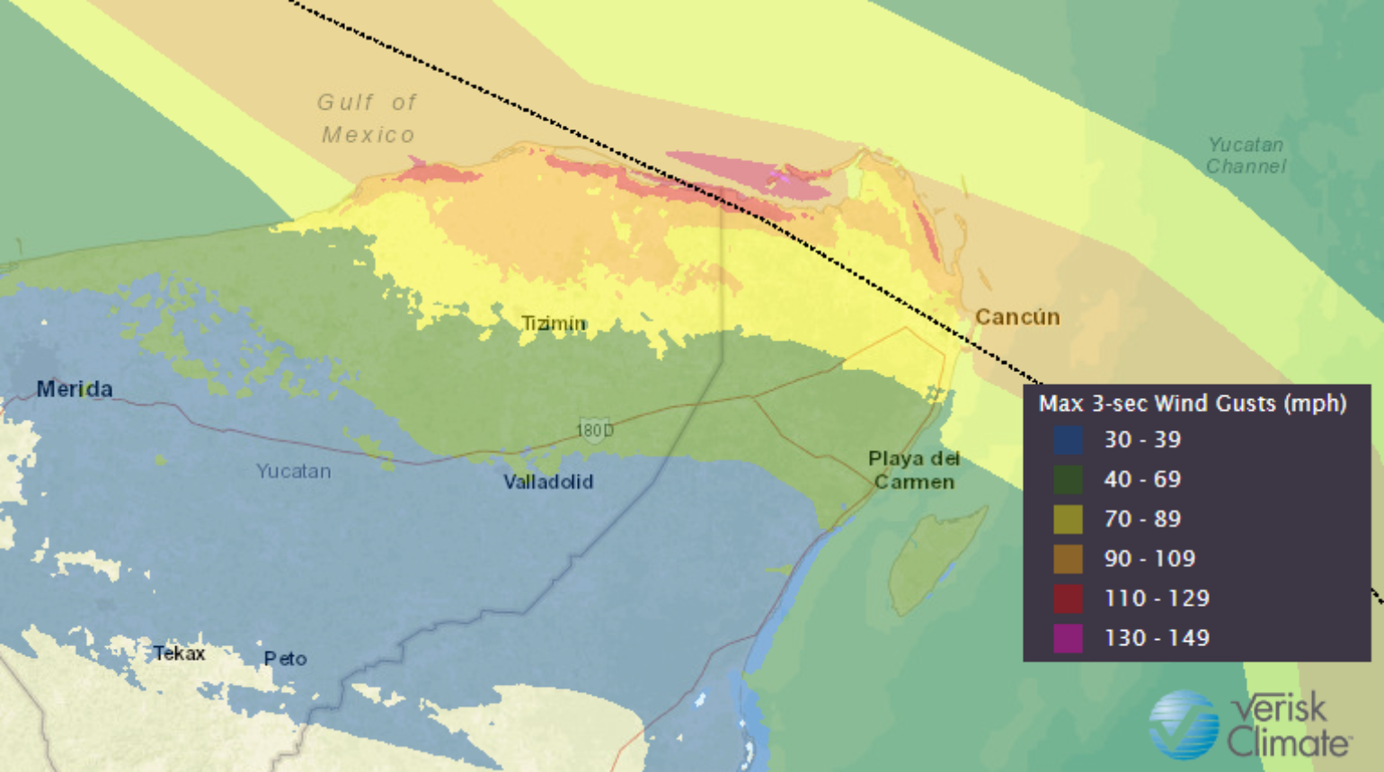
This morning Hurricane Delta made landfall along the northeastern coast of the Yucatan Peninsula near Puerto Morelos, Mexico, as an intense Category 2 hurricane. This is a much lower intensity than forecasted just 24 hours ago, as it has been a roller coaster of a forecast. The pressure at landfall appears to have been around 972 mb, and a WeatherFlow observing site near Cancun reported a peak sustained wind of 84 mph with a gust of 106 mph. It does appear Delta's very small wind field and narrow area of high winds will limit damage to a small area, and the more populated area of Cancun and Playa del Carmen might be just on the fringe of the highest wind speeds. Early storm chaser footage seems to suggest a relatively narrow area of intense damage. The footage also indicates the small eye could have collapsed upon landfall, and a new large diameter eye was formed. This also seems to match the satellite imagery at the time of landfall. Therefore, this does not appear to be a repeat event of Wilma 2005, and longer-term impacts on the tourist industry will likely be limited.

Roller Coaster Intensity
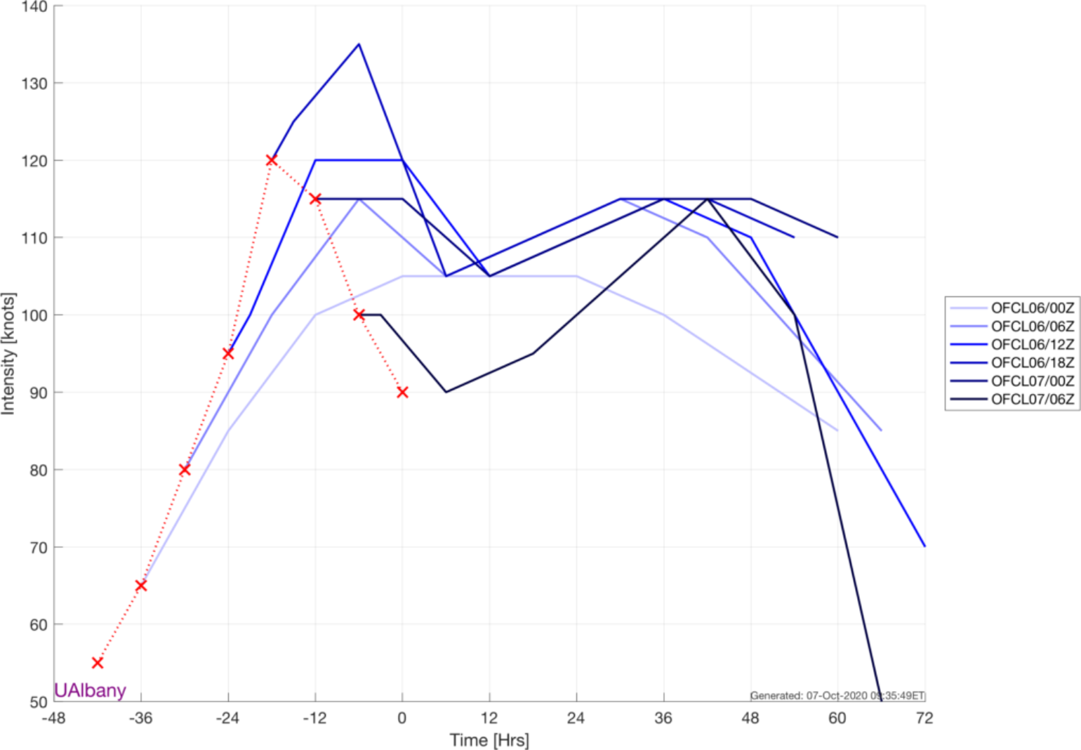
As mentioned, the intensity forecast for Delta has been a roller coaster. As the tropical update was being written yesterday, Delta was rapidly intensifying. In fact, Delta might have set a new record for the largest intensity increase in a 12 hours period. It could very likely, pending further verification in the postseason review, be the fastest intensification from a tropical depression to a Category 3 and 4 storm on record. However, just as fast as it intensified yesterday, it weakened quite rapidly. This led to a real roller coaster in intensity, making it extremely difficult to predict as indicated by the National Hurricane Center (NHC) OFCL forecast intensity trend plot below.

It would appear that the weakening of Delta's small core was a result of some mid-level easterly wind shear. Remember, I mentioned in the tropical update yesterday how a small storm can rapidly intensify. The smaller the eye, the more intense the winds can get thanks to angular momentum's physics. A contracting eye in a hurricane is like it is pulling its arms in while spinning, increasing the wind speed. Think of a figure skater spinning. However, even if the slightest wind blows, the figure skater is knocked off balance, and their arms have to come out, and the spinning slows. This drop-in intensity due to wind shear was not well forecasted by any models. This again highlights, just as we have seen with many of the other hurricane landfalls this year, that the forecasting hurricane intensity still has a long way to come compared to how well we can forecast the track of named storms five days out.
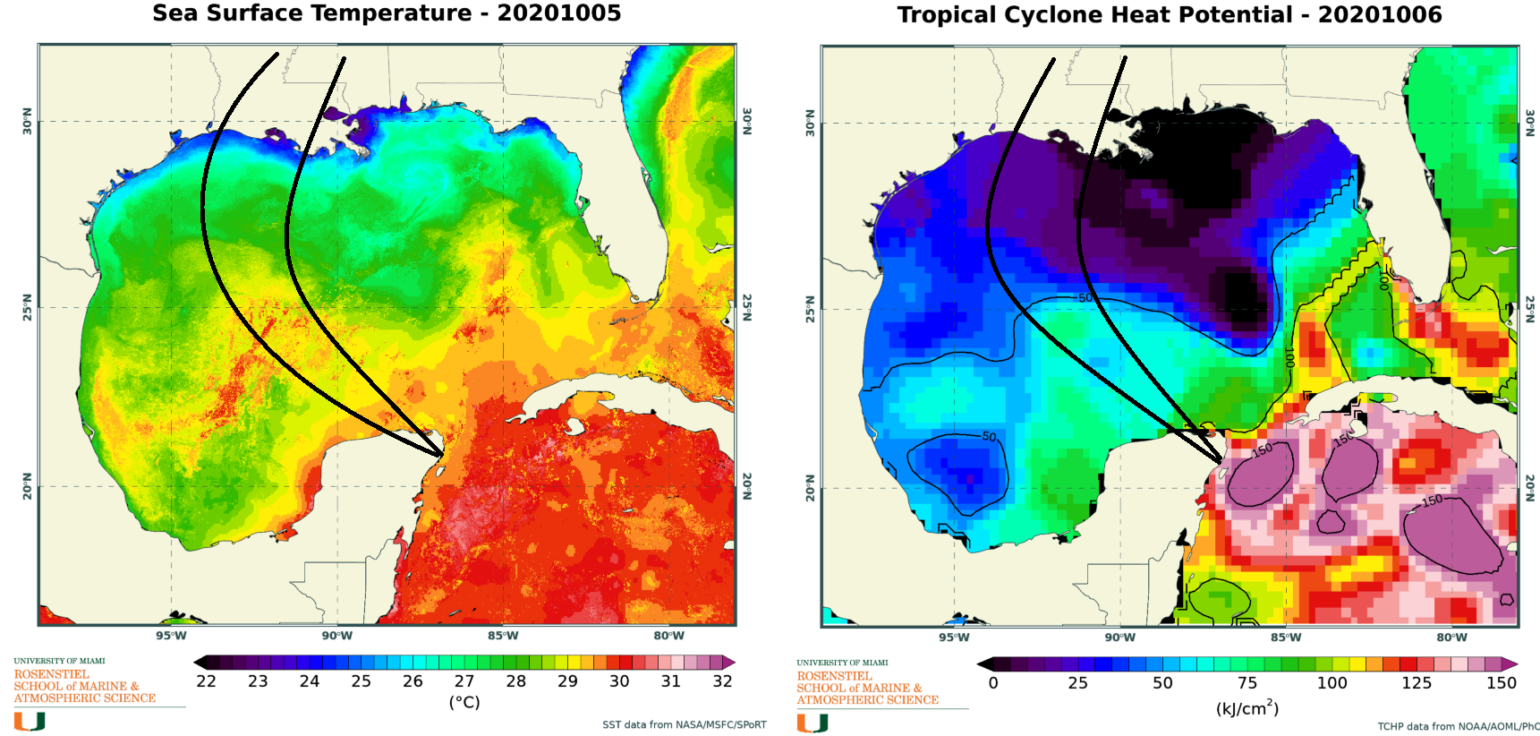
Now the question is, what happens as Delta emerges in the Southern Gulf of Mexico? Delta's time over the Yucatan Peninsula will be limited today. By this afternoon, the storm will be offshore once again and ready to re-intensify. Because Delta will be a bit west of initial forecasts, it will be over the west/central Gulf region with slightly higher Sea Surface Temperatures and Ocean Heat Content. It appears that the overall core of Delta is expanding after landfall, so Delta's wind field will expand and the overall size of the storm should grow.

Provided continued low wind shear and plenty of warm water for fuel, Delta should re-intensify into a larger major hurricane. The NHC predicts a weak Category 4 hurricane tomorrow afternoon. The weakening should start to occur as Delta tracks into an area of very dry air and strong westerly wind shear in the upper atmosphere.
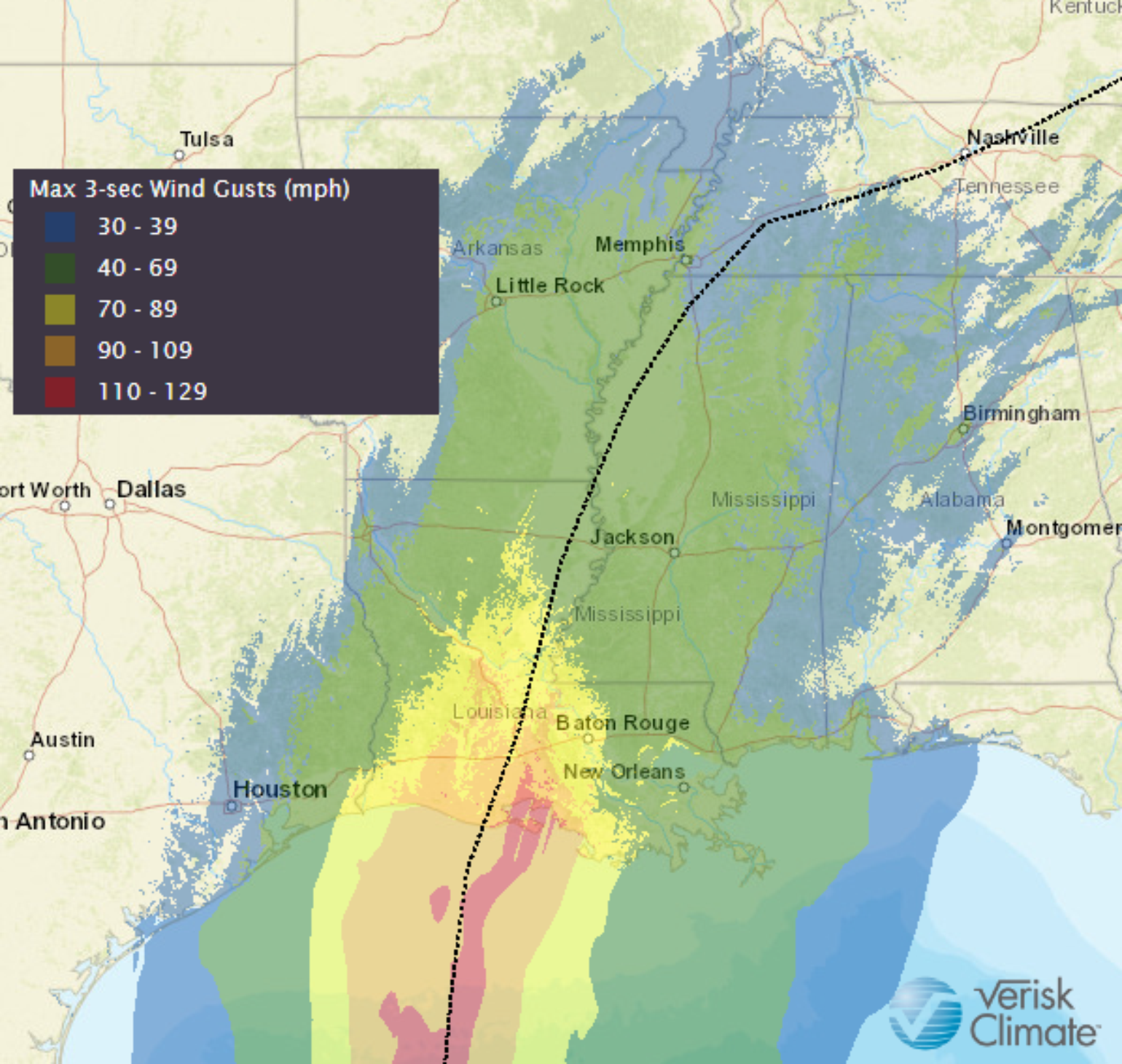
As mentioned in the tropical update yesterday, hurricane Lili in 2002 was a major hurricane that quickly weakened before landfall. The past 24 hours of intensity observations show just how fast named storms can intensify and weaken. Lili might still be a great analog here for a major hurricane in the southern Gulf moving toward Louisiana that can quickly weaken offshore due to cooler waters, wind shear, and dry air. Could history repeat? The NHC is suggesting a rapidly moving Category 3 hurricane at landfall that could have a displaced structure so that the strongest winds will be to the east of the center track and much weaker winds on the left side. Tomorrow I expect a much better idea of wind impacts along the Louisiana coastline.

The model consensus appears that Delta will be making landfall only 30 miles to the east of where Hurricane Laura made landfall in Louisiana. Too close for comfort with so many still struggling in and around Lake Charles. This could also lead to a bit more complicated insurance claims processing if a second event impacted a location. This occurred in 2004 with the three hurricanes that hit Florida.
The other point that needs to be made about the forecast is that the wind field will likely become much larger, which means a bigger wave storm surge could result along the Louisiana coastline. And we already saw just how massive the surge can be with Laura. Currently, storm surge is expected to be about 7-11 feet along a 130 mile stretch of the Louisiana coastline.
Rainfall should not be a factor with Delta's Louisiana landfall because it will be moving so fast. Currently, forecasts of 8 inches of rain is expected to fall. However, due to Delta's fast forward speed, which will limit rainfall and flooding impacts, wind damage could be observed further inland than what might be experienced in storms like Sally and Laura this year.
New Forecast Tools
Unfortunately, there is only time to provide one tropical update a day, but I often get asked for updates from insurance clients and co-workers throughout the day. Tracking the overall changing forecast is easy, and the NHC is the best in the business. They issue several updates to their forecast products and observation every couple of hours, so if you want the latest information, that is the best source. However, for the armchair meteorologist who wants more detail, several tools are useful for looking at some of the points that the NHC might mention. In fact, after several decades, today the world-leading forecast model, the ECMWF, is making many of its products freely available to the public. For years these products came at a very high price. I remember in my first job in the energy industry, and we would pay tens of thousands of dollars for access to this reliable model. So the news today that the products are free is a massive step in data transparency. As Delta tracks into the Gulf of Mexico, here are just a few other open sources of data I use to track named storm activity:
National Hurricane Center - This has all the information you need on the latest storm, as well as some other great tropical cyclone climatology material.
ECMWF graphical products are free and accessible to all! Medium-range, extended-range and long-range forecast charts of temperature, wind, precipitation, clouds and ocean waves are just some of the products available.
Tropical Tidbits - Tropical weather and Atlantic hurricane information, analysis, satellite, and forecasts by Levi Cowan. This is really a one stop shop for everything you might need to be dangerous at your next company meeting discussing storm impacts.
CIMSS Tropical Cyclones - The CIMSS Tropical Cyclone webpage helps provide near real-time imagery, derived atmospheric analysis products, and tropical cyclone intensity estimates from a variety of different satellite platforms for global analysis of tropical cyclones and their surrounding environments. Many of the products from CIMSS are developed specifically for use by tropical cyclone forecasters worldwide to provide unique information in support of their specific forecasting missions.
