In the BMS tropical update on August 30th, it was mentioned that as Ida exited the East Coast of the U.S., there did not appear to be any new storm activity that would impact the U.S. over the following two weeks. Well, that prediction was completely wrong! The prediction was based on a large-scale sinking motion that is currently over the Atlantic Basin, which makes it harder for storms to form into named storms. However, since that update, both Tropical Storm Mindy and Hurricane Nicholas have formed in the Gulf of Mexico and have strengthened right up until landfall. These recent events suggest that climatology and storms in the Gulf of Mexico do not always have to follow rules - storms can still form over very warm water.
Overall, Tropical Storm Mindy will be a non-event for the insurance industry since it made landfall in a sparsely populated area of the Florida Panhandle. However, Tropical Storm Nicholas, which formed on September 12th in the Bay of Campeche, rapidly intensified to a hurricane just as it made landfall near Galveston in the early morning hours of the 14th.
Nicholas had some favorable conditions to work with throughout the day on Monday, September 13th. The water in the western Gulf of Mexico is some of the warmest water in the Atlantic Basin at above 86 degrees F. In fact, Nicholas could have been stronger if it were not for the wind shear and for the dry air being pulled in to limit convection on the west and south side of the hurricane. Overall, some might be surprised that Nicholas ended up being a hurricane at landfall. However, all day yesterday, the National Hurricane Center had posted hurricane watches for the Texas coastline - so the potential was there.
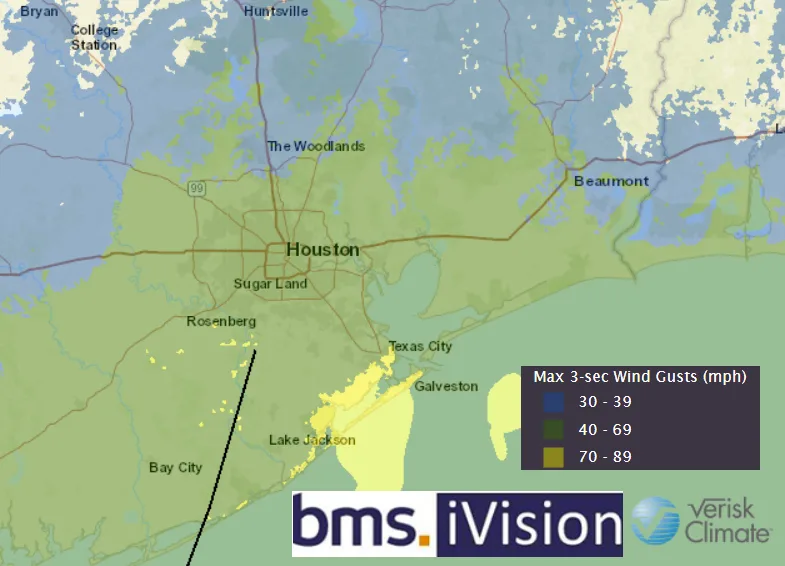
Nicholas made landfall near Matagorda, TX as a minimal Category 1 hurricane. While this area of the Texas coastline is fairly rural, over 500K power outages had been reported in and around the Galveston and Houston areas. Interestingly enough, Nicholas just missed the anniversary by a few hours of Category 2 Hurricane Ike that made landfall in Galveston, on September 13th, 2008. There have been a few other named storms that have had similar landfalls around Matagorda, TX. Last year, Tropical Storm Beta had an insured loss of just over $100M and in 2019, Tropical Storm Imelda had an insured loss of $700M. It is still early, but the insured loss should be similar to that of Imelda, with the main area of uncertainty being the extent of flooding in the Houston area since the flood take-up rate has grown over the years for these coastal counties.
By far, the greatest threat from Nicholas has been, and continues to be, the heavy rain. A large swath of 6 – 12” of rain is expected to stretch across the coastline. The heavy rains are even anticipated to reach New Orleans, which will compound the insured losses that have already occurred in this area.

Time and time again, Houston becomes the focal point of major flooding. Back in 2016, The Texas Tribune provided a great story map that examined the complex problems that have resulted in Houston becoming known as Flood Town U.S.A. If you have the time, it is a good comprehensive deep dive into the issues that keep showing up for the area.
What is the next tropical trouble?
As mentioned above, large-scale sinking motion seems to be in play over the Atlantic Basin, but Mindy and Nicholas have shown that storm development can still occur. The next area that will likely draw the attention of the insurance industry is the African easterly wave. It is rapidly organizing and is already labeled as Invest 95L. This will likely become Tropical Storm Odette at some point as it tracks closer to the Lesser Antilles early next week. This is the next tropical wave to watch as we move into mid-to-late September.It should be noted that overall, the stronger these tropical waves become as they develop, the more likely the storm is to turn northward before the Lesser Antilles. On the contrary, a weaker version is more likely to cruise much closer to the Caribbean.
The other area that needs to be watched is an area of tropical convection north of the Bahamas. There is a chance this area could slowly develop in the coming days as it drifts north. As of now, it is nothing to be concerned about, but it is worth keeping an eye on. The National Hurricane Center is giving the area a 60% probability of becoming a named storm or depression as it moves along the warmer waters of the Gulf Stream between the Carolinas and Bermuda.

There is no doubt 2021 has had a very active period of landfalls for the insurance industry. In fact, of all the named storms that have occurred so far this season, only four have not impacted North America (Ana, Bill, Julian, & Kate). Nicholas continues the active landfall trend experienced last year, with Nicholas now the 19th named storm to make landfall in the U.S. since May 2020. The average is about three per year, which is clearly a drastic change from the quiet period between 2006 and 2016.