

As this update is drafted Ida continues to strengthen and is on the verge of becoming a Category 5 hurricane. Its current intensity is 150 mph, which is just shy of a Category 5 hurricane intensity. Only two other hurricanes since 1851 have made landfall in Louisiana with sustained winds that strong - Last Island (1856) and Hurricane Laura (2020) last year. Both of those hurricanes were 150 mph at landfall and one has to wonder if Ida will be the strongest ever as there are still a few more hours for possible intensification. The last several tropical updates mentioned intensification would continue right up until landfall as Ida tapped into the deep warm ocean water and had no wind shear or dry air aloft to hamper its intensification. Ida will likely go down as one of the fastest intensifying hurricanes on record.
Yesterday’s tropical update started to outline some of the detailed impacts from Ida. It was mentioned that the track would be key to the overall damage to the higher exposure that is around the New Orleans area. This morning Ida is tracking about 25 miles further to the East than what was forecasted yesterday. This means that the strongest winds are 25 miles closer to the city of New Orleans with a landfall expected in just a few hours Terrebonne Bay, LA. in just a few hours. Ida is also stronger with a smaller radius of maximum winds of about 15 miles vs what was forecasted yesterday of 25 miles and there will be a sharp drop-off in wind speeds away from the center of the storm. Therefore, the path of Ida is still very critical as it tracks inland past New Orleans.
Wind Impacts
With a hurricane, this strong one can expect trees to be de-leafed and stripped of bark in the landfall area. Additionally, in the landfall area, the winds will be right at the design threshold as indicated in the ASCE Hazard maps. There is little exposure right around the landfall area south of U.S. Highway 90; however, these small rural towns along the Mississippi River such as Empire, Port Sulphur, and Buras along with the towns of Grand Island, Port Fourchon, Galliano, and Cut Off, will likely see catastrophic damage as wind gusts of 140 mph and storm surge inundated the area. Structures in these areas will be at the limit of the minimum design level according to the ASCE hazard maps. A storm of this intensity will take hours to weaken. The swampy nature of southeast Louisiana does not offer much surface friction and the swampy nature does not instantly cut off fuel to a weakening hurricane-like other landmasses might. Due to the intensity, major damage is expected to towns along U.S. Highway 90, including Houma, Raceland, and Des Allemands. Morgan City will likely be on the weaker side of the storm, but could still see major damage. Right now it is expected that the city of New Orleans will be about 40 miles to the east of the center of the storm. This would result in the city experiencing wind gusts of 80 – 90 mph. Although the city was just impacted by Category 3 Hurricane Zeta with winds of 60 – 70 mph wind gusts, wind gusts of 80 – 90 mph have a damage multiplier of 4.3 times more than what was experienced last year. And although it was discussed in previous updates, there has been some resiliency in the system from Katrina and Zeta roof that has been replaced from Katrina are 16 years old already and winds gusts of 90 mph could cause roof damage regardless of roof age. Ida’s track will be critical here as there will be a sharp fall in wind speeds away from the center of the storm. The closer Ida tracks to New Orleans the stronger the winds will be and given that the trend of Ida is following the east side of the model guidance, it is possible that New Orleans could see even stronger winds than mentioned here. However, in the last hour, a wobble to the west has occurred which is good to see. So again, the track is critical. Further inland the highest winds will parallel Interstate Highway 10 and the Mississippi River, which is dotted with small rural towns. These towns could also see spotty major damage. High winds gusts as much as 80 mph could be experienced well inland near Baton Rouge - which was largely spared some of the strongest winds from last year’s hurricane landfalls. However, given the extreme intensity of Ida, major tree fall and prolonged power outages are expected to be experienced with Ida over a wide area. This will especially be the case given how wet the soil is at this time.

The other wind threat comes from tornadoes that will form from the embedded thunderstorms. It is not uncommon to see as many as 20 – 50 tornadoes from high-intensity hurricanes like Ida.
Given the current intensity of Ida and the track, there is a growing concern of major damage and environmental damage that could result as Ida will track over one of the most critical industrial areas in the US. The industrial corridor between Baton Rouge and New Orleans is home to dozens of key petrochemical sites and important pipelines. In fact, the port complex at Port Fourchon, which will see a direct hit from Ida, services almost 20% of the nation's oil supply. Time and time again we have seen a disaster take out critical U.S. infrastructure. With a squeeze on industrial supply already occurring, one has to wonder what compounding impact Ida might have in the months ahead.

Flooding and Storm Surge Impact
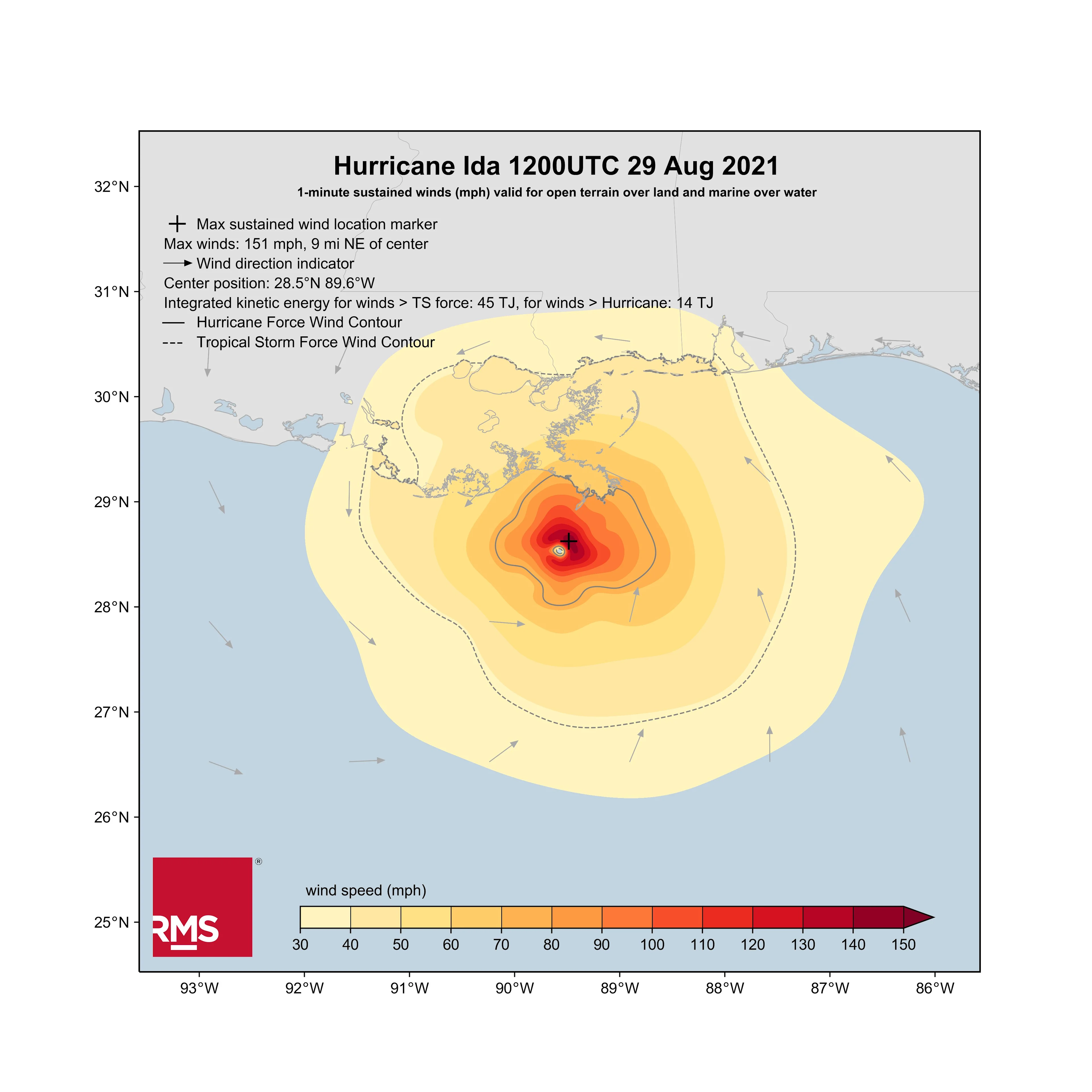
It is certainly surreal that 16 years ago today Category 3 Katrina made landfall in eastern Louisiana. In fact, the RMS Hwind product provides an excellent comparison between Ida’s energy and Katrina. Ida is much more compact than Katrina with less than half the integrated kinetic energy (45 TJ compared to > 100). Ida is no Katrina. Ida will be a major wind loss event and the storm surge, which is better tied to the integrated kinetic energy, will be only severe in the landfall area and will not be as widespread as it was in Katrina.
With that being said, the weakest part of the New Orleans levee system is on the west bank, which will see the highest storm surge. The levee here can protect against a storm surge of 15 feet and it appears the storm surge values on the west bank will be at or just below this level. Of course, as mentioned in the update yesterday, billions of dollars have been spent on improvements. But, the insurance industry has seen that critical infrastructure can fail, thereby resulting in higher losses. So it is still uncertain what Ida will bring in terms of industrial facility losses and storm surge losses if there are levee failures.

On top of the storm surge, behind the levee system, large pumps have also been known to have issues. These pumps will have to remove the expected 15 inches of rain that are forecasted to fall, so once again there are other failure points in the system that need to be watched as Ida makes landfall. Regardless, major flooding should be expected over a wide area as many areas are low-lying and prone to flooding across the southeast part of the state. It should be noted the overall take-up rate for NFIP flood insurance is fairly high across Southeast Louisiana. This goes to show that residents and businesses know all too well the flood possibilities.
Storm surge inundation can be observed using the NOAA Coastal Inundation Dashboard.
Given the slight eastward track shift closer to New Orleans and the overall stronger intensity of Ida at landfall, which could be a Category 5 and most certainly the strongest of Category 4 hurricanes, the insured losses will now likely exceed $10 billion, if not more, as the damage will grow exponentially depending on the wind speeds experienced in New Orleans. In some regards, this might be like the wind swath of Hurricane Charley in 2004, which had a very narrow damage swath. Like the wind swath, the highest of the storm surge will be narrow due to the lower integrated kinetic energy of Ida. However, a lot of reliance efforts such as levees and pumps are critical to keeping a large amount of exposure free from water damage. This will need to be watched carefully as Ida makes landfall.
There will be another tropical update tomorrow looking at some of the damage from Ida as well as other impacts as Ida tracks into the Tennessee River Valley - possibly producing a flood event in the Northeast as Ida merges with a frontal boundary over Pennsylvania and New Jersey.
Ida is likely the last-named storm impact for while as overall tropical activity in the Atlantic will go quiet for the peak of the hurricane season. So from September 7th to the 25th, the Atlantic basin should be fairly quiet. However, lately, we have seen the end of the season be very active, so the season is not yet over.


