

The Louisiana coastline is about 24 hours away from starting to feel the first impacts from Hurricane Ida. The last couple BMS Tropical Updates have made it very clear that Ida would be rapidly intensifying due to ideal conditions, which include little if any wind shear and limited dry air entrainment. The warm sea surface temperatures are not just at the surface. Warm water that is 86 degrees and up to 150 feet deep will act as jet fuel to Ida’s intensification today. So far the observed intensity from Ida has been overachieving the prediction.

The result of Ida forming into a hurricane yesterday means that there is still upside to the overall forecast in terms of intensity, which at this point calls for Ida to be making landfall as a solid Category 4 hurricane with winds of 140 mph. Ida will join an exclusive list of five other hurricanes that have made landfall in Louisiana since 1851 as a Category 4 or stronger hurricane. This list includes: Last Island (1856), Cheniere Caminanda (1893), Betsy (1965), Camille (1969), and Laura (2020). It should be noted that Katrina was only a Category 3 hurricane at landfall. As mentioned in past updates, nothing is stopping the intensification at this point besides time. Landfall is just about 36 hours from now and Ida should intensify right up until then. The time it takes to rapidly deepen to a Category 4, in theory, is about 36 hours, but all this will depend on a few other factors – such as: how many eyewall replacement cycles it has and how large the overall wind field becomes. Both of these factors are important to understanding the landfall impacts to the insurance industry.
Wind Impacts:
There has been very little track change, suggesting that Ida will make landfall as a major hurricane between Vermillion Bay, LA, and Grand Isle, LA. The strongest winds of a hurricane are on the right side of its track. As mentioned in the Tropical Update yesterday, the overall damage and insured loss impacts will depend on the final track of Ida. The further East the track is, the higher the expected insured loss is due to higher winds in the New Orleans metro area. A track to the west would mean manageable winds for the New Orleans metro area. The BMS iVision Verisk Respond product suggests the radius of maximum winds will be 25 miles and the extent of the hurricane-force winds will be 45 miles from the center.
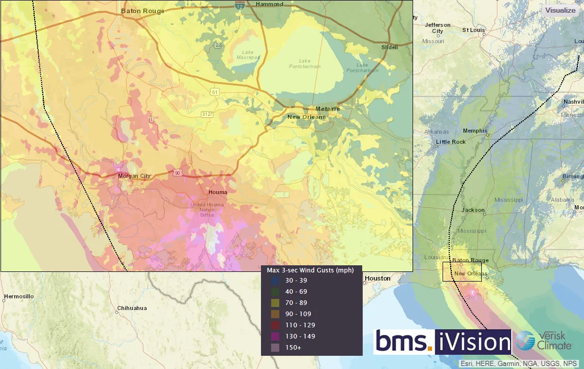
As mentioned yesterday, this difference in the track can mean a single-digit billion-dollar industry loss versus 10’s of billions. Thus far track guidance has been very constant, taking the strongest winds to the west of New Orleans. The overall exposure south of U.S. Highway 90 is very limited and the towns that dot U.S. Highway 90 are smaller and rural. There is still uncertainty on the overall size of the wind field. However, these stronger winds could extend into the New Orleans metro area with a track shift. As mentioned in yesterday's update, New Orleans did experience wind gusts over 60 mph last year with major Hurricane Zeta landfall which overall had limited damage to insured property. But the central part of the state from Lafayette and Baton Rouge were largely spared from stronger winds last year. These cities are further inland where the frictional effects will weaken the winds; but as experienced in Lake Charles last year from Laura, similar Category 4 winds have shown just how severe damage can be away from the landfall location. These inland locations have not experienced high winds over 60 mph in several years, so tree fall could likely result due to the fact nature has not had a storm in the area to clean itself. Overall, the heaviest damage should occur to structures along U.S. highway 90 and should still likely see winds below the minimum design codes as outlined by ASCE 7 - but this all this depends if the codes were followed.
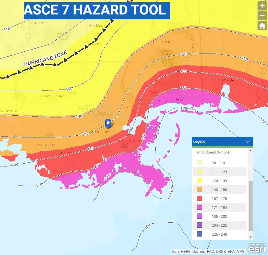
It should be noted, that in the fourth edition of the Insurance Institute for Business & Home Safety (IBHS) Rating the States report evaluating building code enforcement and administration, and contractor licensing, Louisiana scores an 82. This is higher than most of the Gulf Coast states and much of the Louisiana coastline is within the zone where wind speeds can exceed 130 mph. This effectively makes the wind design requirements of the international residential code mandatory and the codes are followed fairly well across the state according to the IBHS report.
Storm Surge and Flooding:
Ida is not forecasted to stall and should be moving fairly rapidly at landfall. This will limit the inland flooding impacts. However, many parts of Southeast Louisiana have already seen 70 inches or more of rain year to date, including parts of New Orleans and Baton Rouge that are very prone to flooding. Another 8"-15" could fall through Monday. However, a bit of good news that has not been discussed is how low the Mississippi River is due to a dry summer over much of the Central Plains and Upper Midwest. This will not only help mitigate the impacts of flooding rains, but any storm surge that pushes up the river will have more room due to lower river levels. Below is the river gauge of the Mississippi River at New Orleans. This shows the low water level and the forecasted rise of 11 feet is well below any record water height. Although this is a bit of good news, local flooding in a low-lying area is already common in Southeast Louisiana. Therefore, major rain-induced flooding should still be expected in many areas.

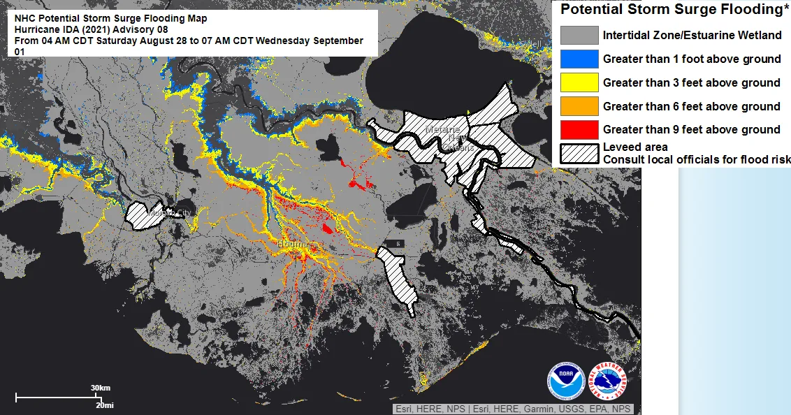
Storm Surge is also a major concern and will ultimately depend on the track and size Ida becomes over the next 24 hours. Peak surge is expected to be 10 – 15 feet from New Iberia, LA to Grand Isle, LA, with up to 7 – 11 feet of storm surge expected around New Orleans. This is below the design threshold of the New Orleans levee system. In cities along U.S. 90 Highway, the surge levels could be closer to the design threshold for the levee system protecting cities like Morgan City, LA, Cut Off, LA, and Galliano, LA. Cities like Houma, LA have limited protection and will be impacted to a greater level. However, once again, as mentioned in the post yesterday, the overall system has seen resiliency improvement. Since Hurricane Katrina in 2005 $14.5 billion has been spent upgrading cities' flood defense systems. Hurricane Isaac brought 12 – 14 feet of storm surge into the city of New Orleans and it seemed the new improvements performed marvelously. This should give the insurance industry confidence that the projected storm surge of 11 feet can be managed. However, once again the storm surge forecast is tied to the overall intensity and size of Ida before landfall. Along with the NHC forecasted track guidance the NHC has a very detailed storm surge forecast that should be used as guidance to storm surge impacts along the Louisiana coastline.
At this point, there should be no surprises with Ida going forward. Ida will be a major hurricane at landfall and the insurance industry impacts will be largely determined by the landfall location and the size of Ida. Eyewall replacement cycles will be critical in determining the size over the next 36 hours. If an Eyewall replacement cycle is occurring at landfall that could also be good, but if one had just occurred that could result in stronger winds at landfall. Right now, the core of the strongest winds looks to be forecasted to be just West of New Orleans, and the storm surge looks to be manageable for the city but more severe for the coastal section to the west along U.S. Highway 90.
Stay tuned for more BMS tropical updates that will follow with more insightful impacts on the insurance industry. Tomorrow the landfall location will be locked and we will know the extent of the wind field of Ida, which will allow for an even more detailed analysis of impacts to the insurance industry.


