

Today is the 1st anniversary of major Hurricane Laura making landfall on Cameron, LA as a very strong Category 4 hurricane - so if you are having a bit of Déjà vu that is for a good reason. Given the current forecast track of Ida to impact more of Eastern Louisiana and that Sunday is the anniversary of Katrina (2005) landfall, it is clearly understandable that the current scenario for Ida is jogging the memory.
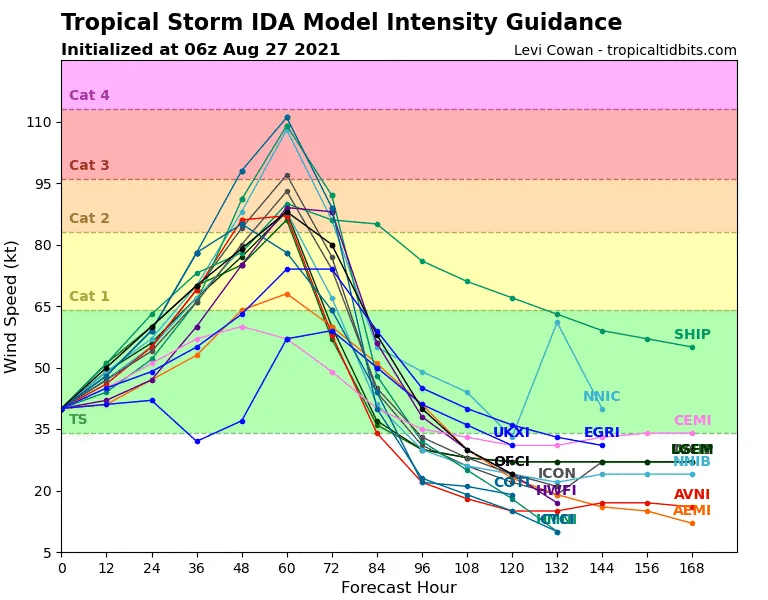
In yesterday’s BMS update it was discussed how the potential was there for Ida to rapidly intensify due to the warm sea surface temperatures of the Gulf of Mexico and that there is a historical precedent in storms doing this from the current location of Ida. It was mentioned that Laura was a tropical storm tracking over the Western tip of Cuba similar to what Hurricane Ida is forecasted to do today. Zeta last year was also a tropical storm after impacting the Yucatan, but quickly restrengthened into a major hurricane tracking right over New Orleans. The worry with Ida is not just the warm sea surface temperatures, but the overall depth of these warm waters. NOAA has a program called Argo that deploys over 3,000 free-drifting ocean monitoring buoys around the world. These Argo buoys can help understand how warm the water is at depth. Buoy ID 4903356 shows water over 30 C (86 F) to a depth of 40 m (131 feet) deep. It is not just the surface water that is a concern, the depth of the warmth as wind and waves pass can easily create an upwelling of the cooler surface water ahead of a named storm causing it to weaken. This is not the situation with Ida given the depth of the warm water. Therefore, it is expected that Ida should strengthen right up until landfall.

The only limiting factor on the intensity of Ida at this time will be the amount of time before landfall. The forecast models are tracking Ida a bit faster than the forecast 24 hours ago. The best-case scenario for a weaker Ida at landfall would call for a slower developing storm in terms of its structure after crossing the Western tip of Cuba, which would result in less time for Ida to tap into the deeper warm water before landfall. However, if Ida can cross the Western tip of Cuba with a relatively good structure it will have plenty of time to rapidly intensify. This is what the forecast is calling for; but again the overall time is short, so this could limit top-end intensity - which is why right now there is no forecast support for a Category 4 hurricane at landfall from the very hurricane intensity models.
Regardless, either a strong Category 2 or Category 3 hurricane making landfall somewhere between Grand Chenier, LA, and the Mississippi Delta will be impactful to the insurance industry. However, the magnitude in terms of loss comes down to track. It is not until the catastrophe risk models start issuing stochastic track guidance that one realizes that a 50-mile difference in the landfall area can have a huge impact on the vulnerability and exposure that drive the loss. It could range from a simple single-digit billion dollar loss to a 10’s of billions dollar loss if the storm were to track closer to a major metro area like New Orleans. These models can be very sensitive to track and intensity, which is why the intensity forecast along with the track matters; but, at this early stage for track all scenarios within the NHC cone of uncertainty are on the table. This is why there is likely to be a large range in estimated insured losses over the next 24-hour hours.
This is also where experience can be taken into consideration. As mentioned, today is the anniversary of Hurricane Laura, and looking back at all the named storm landfall that impacted Louisiana in 2020 (Cristobal, Laura, Delta, Zeta) one has to think some type of resiliency is starting to get established. As mentioned in yesterday's post, many should be amazed that Category 3 Zeta tracked right over New Orleans only causing an industry estimated loss in Louisiana of just $800 million. Granted the strongest winds on the right side of the storm were away from most of the city, but New Orleans International airport still had a gust of 62 mph, and the Belle Chasse Naval Air Station just 18 miles to the southeast from the airport had a gust of 76 mph. Was there overall some resiliency built into the system after Katrina in 2005? Are the catastrophe models keeping up with this resiliency? After Laura's impact, it was found that the losses would have likely been much higher had not hurricane Rita (2005) also impacted that same general area. Granted tracks here can make all the difference and a track of Zeta 10 – 20 miles more North likely would have resulted in more loss.
Overall, according to the Louisiana Department of Insurance, data call files 317,329 claims had been filed from last year's hurricane landfalls. It appears however only 65% of those claims are closed, so the recovery process is still ongoing for some policyholders. But the hope is that those that have recovered have built back better. Maybe it is not just building back better, maybe the recent storm activity has likely already cleaned out some of the old or weak trees so losses could be less just from tree fall. In contrast, if Ida tracks are closer to Lafayette, that area did not see the strong winds from Laura and Delta, or Zeta so the overall resiliency in the system is likely lower.
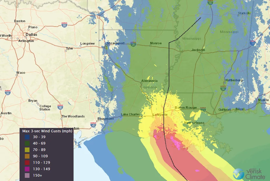
There will be other factors to consider going forward like how wet much of Southeast Louisiana has been. Some areas have seen 70 inches of rain year to date. And another 8-15” of rain will not be welcome news to bayous that are already very wet and low-lying flooding areas. Storm surge will also be a concern regardless. We all know New Orleans is below sea level, but right now 7 – 11 feet of surge will have an impact and the stronger and larger Ida becomes before landfall will drive storm surge impacts. It should also be noted that Ida is not expected to stall and be moving fairly rapidly at landfall, which will mean inland impacts will be greater. This clearly will not be good news for the Tennessee River Valley area that is trying to recover from the devastating flash flood this past weekend.
Stay tuned for more BMS tropical updates that will follow with more insightful impacts on the insurance industry over the next few days.