

Tropical Storm Elsa is poised to continue to strengthen for the next 24 hours right up to landfall on Wednesday morning. This leaves a window that Elsa could become a hurricane right at the time of landfall and hurricane conditions could be observed. This is why the National Hurricane Center (NHC) has issued a hurricane watch for a portion of west-central and Big Bend Florida Coastline.
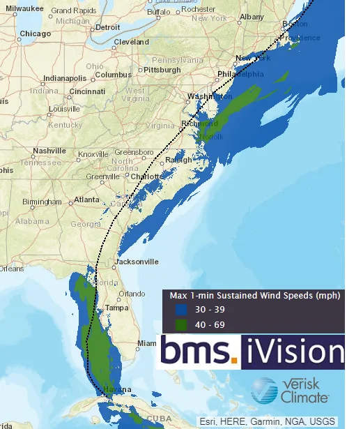
Since late last week, the general idea of Elsa tracking up the West Coast of Florida has not changed. The acceleration north-northeast of the center of the storm towards the general direction of eastern Apalachee Bay and the Big Bend part of the Florida coastline is the most likely landfall locaiton.
The biggest uncertainty over the next 24 hours is if there is enough time for Elsa to restrengthen. Elsa will be experiencing 15 to 20 knots of wind shear from the west, which can be highly detrimental and when combined with some dry air that could also be entrained into the core of the storm. These are likely just a few factors as to why Elsa will stay a disorganized tropical storm over the next 24 hours. The majority of the forecasted intensity guidance shows dry air influx and wind shear through landfall; however, if Elsa can maintain deep convection near or over the center of circulation today, this could lead to continued straightening of Elsa. The probability here is very low at this time. The ECMWF model is one of the only dynamical models predicting a hurricane at landfall, which is a real test for this model in what looks to be a busy hurricane season of model watching.
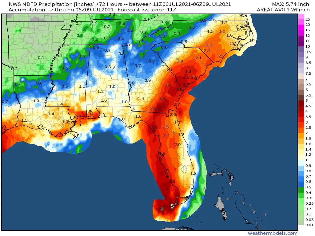
Elsa is a good reminder that storm impacts can be felt far away from the center of the storm, especially when viewing the NHC 24 hr cone of uncertainty forecast which only has an 80-mile swath. Regardless of intensity, impacts for much of Florida are unavoidable. The most widespread impact of Elsa will be rainfall. Key West will likely get the most rainfall from Elsa with 5” expected. 2-3” of rainfall will likely be observed over the life of the storm from Southwest Florida into North Central Florida, including the eastern Big Bend. Totals over the eastern peninsula will be closer to 1-3”. For the Panhandle, the fact that the eastern half of Elsa will be much wetter than the western half means a relatively sharp gradient in rain totals will probably slice through the central Panhandle or western Big Bend, even with a track into Apalachee Bay.
Regardless if Elsa does not strengthen much, wind and surge impacts are also certain along the immediate Gulf Coast. A southerly fetch of offshore tropical-storm-force winds will cause coastal flooding in south-facing sections of the coast, including eastern Apalachee Bay and possibly low-lying sections of Tampa Bay. Although not forecasted by the NHC the Tampa area could get 3-5ft of surge when tides are at highest levels overnight. The tide is aided with the counter clockwise winds pushing water in just as tides will be rising might surprise some.
While widespread, severe wind damage is not expected. However, tropical-storm-force winds along the Gulf Coast and potentially inland over North Florida could certainly cause tree damage and some power outages. Lastly, land falling tropical cyclones very commonly produce tornadoes east of their track, and Elsa will likely do the same.
One of the bigger changes in the extended range forecast for Elsa is the shift to a track of Elsa overland up the East Coast of the U.S and not offshore as indicated over the first part of the weekend. This will provide a bit of opportunity for very minor impacts to insured properties along the East Coast as Elsa at this point is a tropical depression or remanent tropical system with very minor wind and rain impacts.
Overall, Florida has certainly faced worse than Elsa, but the storm has the potential to be an underestimated threat. As mentioned in the update on July 3rd, even Hurricane Eta, which impacted the Florida Keys and had a similar landfall area as Elsa as a tropical storm, still caused over $700 million in insurance industry loss. So even the weakest of storms can have impacts on the insurance industry.
As mentioned in the July 1, Elsa might be a harbinger of bad news no matter what impact it has on the U.S. this week. The 2021 Atlantic hurricane season has joined an exclusive group of hurricane seasons. Since 1980, only 6 seasons saw a hurricane in the 1st 10 days of July. These years are 1996, 2003, 2005, 2008, 2010, and 2014. All of the season except 2014 were active seasons. 2014 had cooler Atlantic sea surface temperatures and El Nino conditions during the peak of the season which is not occurring this season. The analog years above indicate some fairly large insurance industry loss years, but also a couple of years with a limited insured loss. Therefore, at this time the dice seem to be loaded for a busy season, but it is not a given for large insured loss (As also touched on in the July 1st update). Elsa and the tropical wave activity experienced last week gives the insurance industry an indication of possible tracks this year which seem to be aimed at a more southern track toward the Caribbean and Southeast coastline given the dominance of the Bermuda high and early steering flow that could persist over the peak of the season in August and September. The good news is an area of large-scale sinking upper air motion is starting to dominate the Atlantic Ocean. This means that the next few weeks will be relatively quiet in the Atlantic basin with the next active pulse of upper air support expected to enhance African Wave activity after July 24th or so.


