Nail Biter and Wobbles
As of this morning, Milton is beginning to encounter unfavorable conditions and is no longer a Category 5. The satellite loop shows the eye becoming more offset, with signs that it is starting to fill in.
These BMS Tropical Updates have provided ideas of what is possible with Hurricane Milton all week. With less than 15 hours before landfall, it still seems to be a nail-biter as Milton's only escape route out of the Eastern Gulf of Mexico is across Florida. We have been talking about different track scenarios all week, and even now, there remains uncertainty about whether this will track closer to Tampa or to the south near Venice, FL. At this stage, every slight shift in Milton's path as it approaches Florida's west coast will be crucial for determining the exact landfall location, and these shifts can continue right up until landfall. There is no change in the thinking that landfall will be around Longboat Key, FL, which is a more ideal scenario for the insurance industry as it would put the strongest wind and surge to the south of the Tampa Bay area. Milton will make landfall late tonight around 1 am local time as a Category 3 hurricane. The NHC intensity forecast is at the high end of the model guidance. At present, Milton seems to be favoring a rightward shift from the official NHC forecast track, steering it on a more southern trajectory. However, there have been no indications of an eyewall replacement cycle overnight, meaning the storm still has a very tight core. While Milton is expected to undergo changes before landfall, the extent of these changes remains the multi-billion-dollar question. There still appears to be two different camps within the forecast models. Yesterday, we discussed two camps within the forecast models: the camp that would keep Milton a Category 4 intact tight core hurricane or a weakening expanding hurricane at landfall. Ultimately, it will be a race between weakening and landfall that will determine just how catastrophic Milton's landfall will be. However, do not focus so much on Milton’s category clarification; instead, focus on the specific impacts provided below.

Wind Impacts
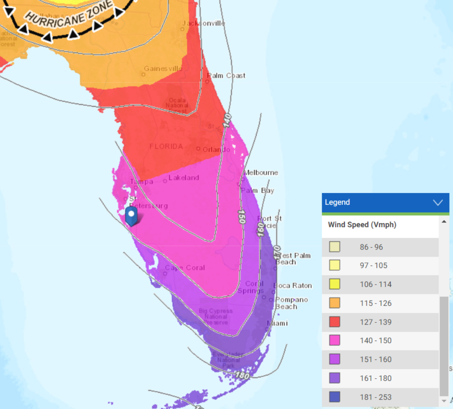
There are still some questions about what Milton's structure will look like when it makes landfall. Will it entrain dry air, and will shear weaken its core? Will it start to undergo an extratropical transition? As shown below, Milton's wind field will gradually expand before landfall, widening the swath to damaging winds upon landfall. The strength of the winds on the storm's backside, particularly on the left side expected to impact Tampa, will be a key factor in determining the scale of insurance industry losses from Milton. This area contains much of the region's older housing stock, which is more vulnerable to damage and not built to current code standards. In Sarasota, FL, the wind-rated building codes are based on the 7th Edition (2020) Florida Building Code (FBC), which references the ASCE 7-16 standards. The ultimate design wind speed for Sarasota varies depending on the risk category of the building. Still, most residential structures would fall into Risk Category II and have a design wind speed of approximately 140-150 mph. Risk Category III and IV buildings (essential facilities like hospitals and emergency shelters) have higher wind speed requirements. Windows and other openings must be impact-resistant or protected if located within one mile of the coast where the design wind speed is 130 mph or greater. However, keep in mind that this only applies to the newest buildings. Further, the anticipated landfall area has not experienced a devastating storm in over 100 years, meaning that buildings in the region have not been tested against the winds that are forecasted.
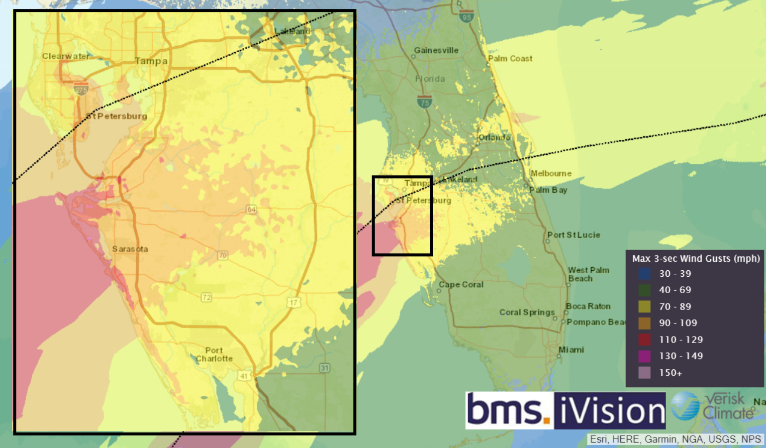
Below is the BMS iVison Verisk Respond 3-second wind gust product, which shows Milton tracking right into Tampa Bay, which would put the strongest winds to the south side of the storm near Sarasota. Over the last several days, it should be noted that the Verisk Respond wind model has had this north bias compared to the NHC OFCL forecast, which has been further south. This forecast product gets updated four times daily to provide realistic scenarios of what is possible given the uncertainty in Milton's landfall location. The strongest wind gust should be expected over the Sarasota Region down to Venice, FL.
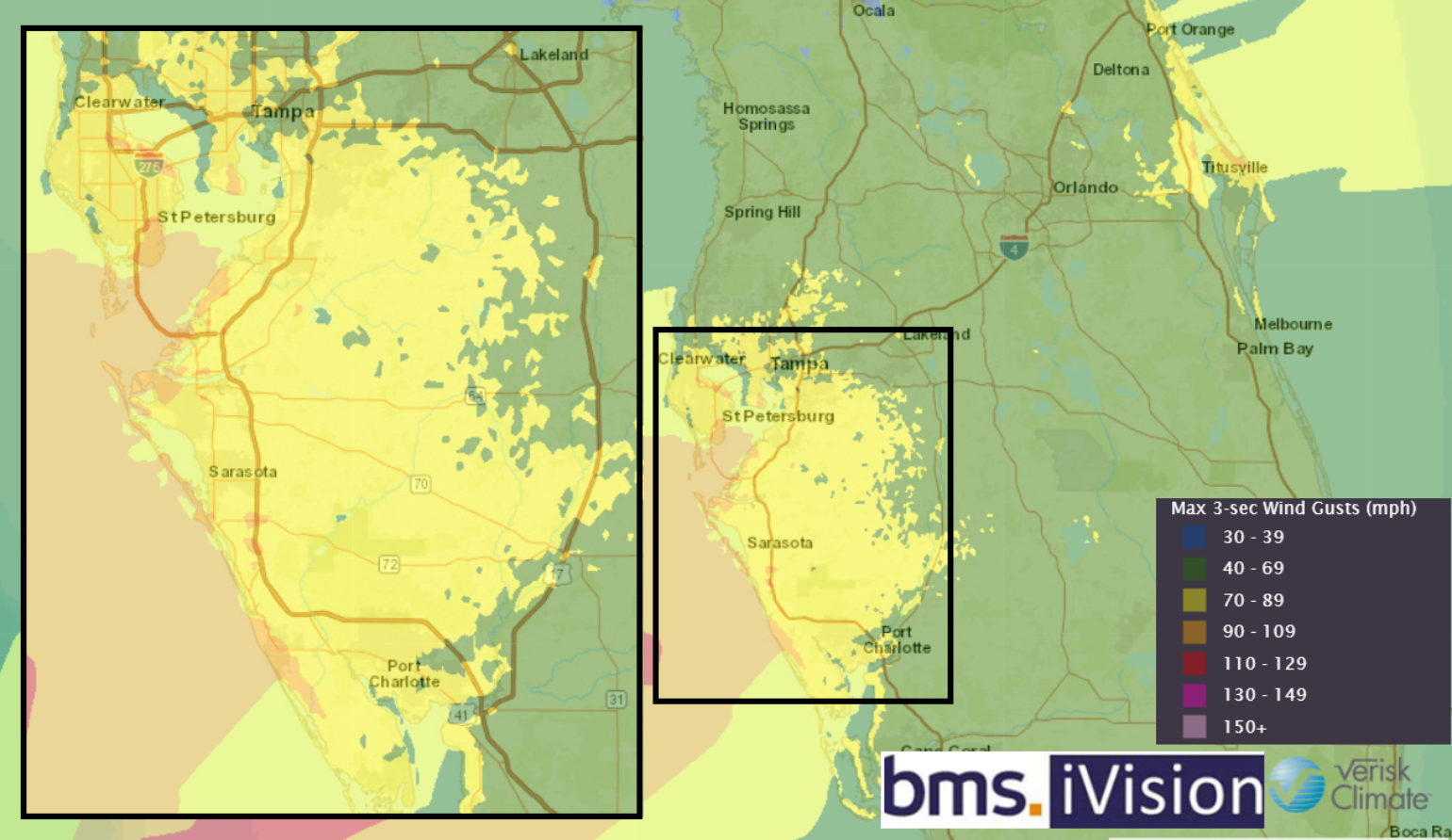
It is important to note that in the BMS iVision Verisk Respond Wind swath, high winds are expected to extend well inland along the I-4 corridor, with stronger onshore winds around Daytona Beach. As a result, the overall wind impacts will be widespread. Additionally, strong winds could occur on the northwest/back side of the storm as Milton will be interacting with a frontal boundary and beginning an extratropical transition, which could still put Tampa Bay Metro areas under higher-than-expected wind gusts. However, structures with newer roofs should be able to withstand these wind gusts, which then leads into the question of how higher required wind deductibles will play into marginal damage. Regardless, there will still be the burden of the claim handling process, which an expense carrier will be left with.
Storm Surge Impacts
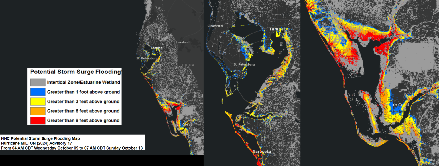
Considering the likely scenario that Milton will track south of Tampa Bay, and referencing our Tropical Update from 10/07/2024, it is important to note that the strong push of water will be on the storm's right side. Therefore, based on the current NHC official forecast, a record-breaking storm surge is unlikely as Milton moves south of Tampa Bay. However, any shift north in its track could alter this situation. With each forecast, the storm surge inundation will be refined. Below is the latest storm surge map showing the hardest hit areas of storm surge: Punta Gorda and Port Charlotte. This will be a record-breaking surge event for these areas. Areas to the south, like Cape Coral, might have a storm surge similar to what was experienced with Hurricane Ian (2022). However, any shift north in track will result in a larger storm surge into Tampa Bay. Yet right now, it looks like the storm surge will be much more manageable for the Tampa Bay Metro Area. Remember, however, the overall insurance flood take-up rate in Manatee and Sarasota counties is 10 to 25%. In contrast, counties to the south, such as Charlotte and Lee counties, have take-up rates of 25% to 50%. In general, there is just much less exposure to storm surge along the coast compared to Tampa Bay Area.
As discussed yesterday, the storm surge will occur as the high tide comes in, which will enhance the storm surge from Milton, given its expected landfall around midnight local time. With the storm surge less focused on the Tampa Bay areas, we must remember that the Helene storm surge also impacted parts of Sarasota. There is still plenty of trash lining the streets of areas like Lido Key and Siesta Key, which enhances the amount of storm surge debris after the storm surge recedes, with some of it washing back into the Gulf of Mexico.
Rainfall / Flooding Impacts
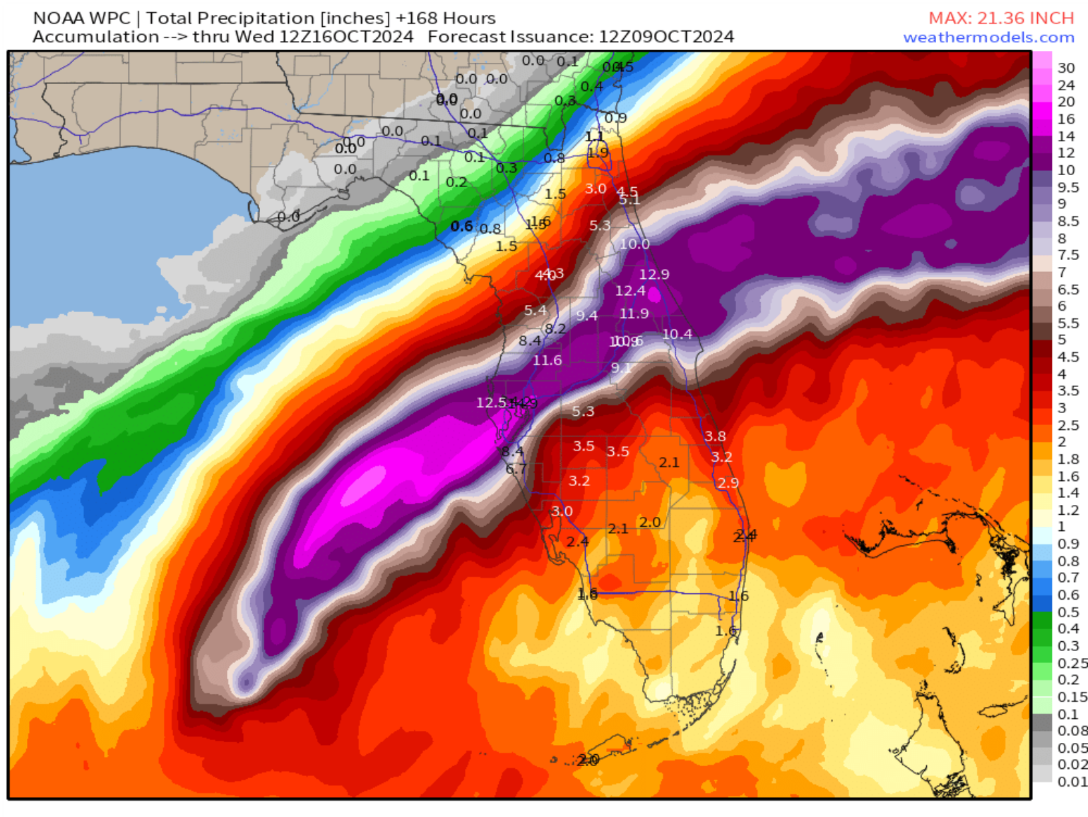
Rain has already started to fall across South Florida as Milton approaches from the west. Between now and Thursday night, Milton will likely dump record amounts of rain in North-Central Florida. Freshwater flooding is expected to be an issue along and north of the storm’s path, especially from Tampa to Orlando and points north, like Daytona Beach and St Augustine. The latest 5-day rainfall forecast from NOAA below highlights an area across primarily central and northeastern portions of Florida where 4 to 12 inches of rainfall with locally higher amounts of up to 18 inches will be possible. It is also expected that significant river flooding will occur, with moderate to significant flooding forecast for some rivers across central and northern Florida.
Lastly, we need to remember that the soil conditions across Florida are very saturated, which will result in an increase of tree fall. Consequently, we expect enhanced tree fall damage and power outages due to this enhancement.
Tornado Impacts
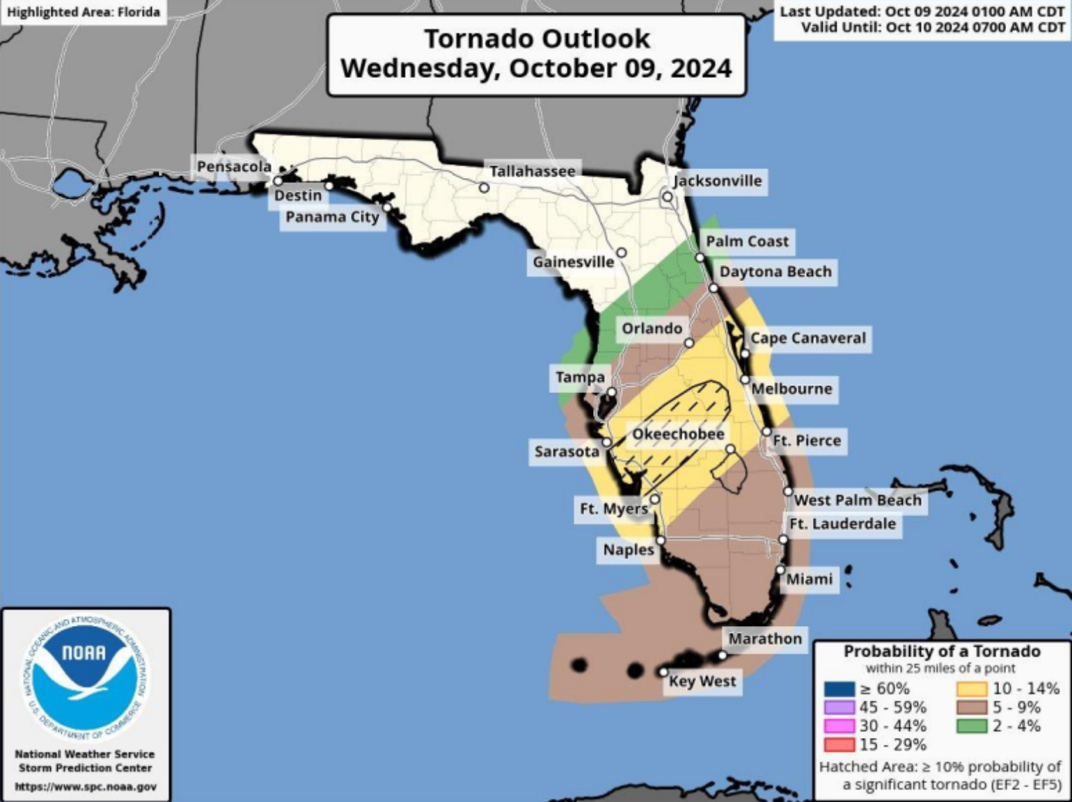
The several hurricane landfalls have inflated the overall U.S. tornado count this year. Milton will add to that overall count per year, which currently stands as the second-most tornadoes observed in the U.S., behind the very active year 2011. The tornado threat associated with Milton will be today, with the greatest risk for tornadoes likely to be across portions of central and southern Florida as Milton makes landfall. Remember, these tornadoes are often weak, short-lived, and hard to classify compared to other possible wind damage from stronger hurricane wind gusts.
Milton Legacy
It seems that Tampa Bay has avoided the threat of record-breaking storm surge and wind event. However, a northward wobble could raise concerns. Given that the forecast bias leans south and Milton is expected to move nearly due northeast, it should track just south of Tampa Bay. Any leftward shifts today could bring it closer to the area. Wind shear also appears to be starting to affect Milton. This process was well forecast; still, the billion-dollar question is whether it will happen soon enough to weaken Milton before landfall substantially. There is still a lot of Category 5 energy in the ocean that will take longer to go away, enhancing the storm surge regardless of the category at landfall. And remember, as weakening starts, the wind field will quickly expand, increasing the overall swath of damaging winds as Milton crosses Florida. As we saw with Hurricane Helene and its eastward landfall, one should not commit to one outcome. Plenty of catastrophic risk modeling scenarios will help the insurance industry understand Milton's potential losses. The fears of the top ten loss event seem to have passed with the shift in track away from Tampa Bay, but this will still add to the already $16B loss of five landfalling events so far this season. How much it adds to the loss is still in question, but it would appear that a $15B event is not out of the question for the insurance industry, but the much higher loss scenarios of yesterday are likely off the table.
Observational Resources
Below are some links for the armchair meteorologist to follow as Milton Makes landfall.
Storm Surge Webcams: WxLogic is deploying Hazcams in the storm's path
Windy: This is an excellent resource for real-time wind observation
Storm Surge: The NHC Storm Surge Inundation Map
Radar: National Weather Service Radar Site
