Fall Is Here, but Tropical Weather Persists
Yesterday at 7:43 a.m. Central Time marked the Fall Equinox, but just because the calendar says it is fall does not mean hurricane season is over. In fact, tropical activity is already stirring in the Western Caribbean. While fall usually signals the end of the Cape Verde wave season, attention now shifts to the Western Caribbean for potential tropical development, which is to be expected. However, Cape Verde-style tropical systems can still form, and one may emerge this weekend as tropical weather continues into the latter half of the Atlantic hurricane season.
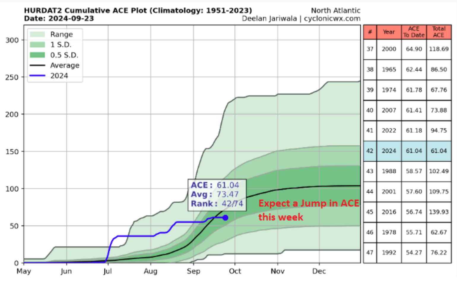
Typically, the 8th named storm of the season forms around September 9th, another indicator that this season clearly is behind normal and well behind the outrageous seasonal forecast predictions of 20+ named storms. The next named storm will be Helene. If the next named storm develops into a hurricane, it would mark the 5th hurricane this season, which forms on average around September 28th. So, if this happens, the season will be ahead of normal for hurricane development, with the average number of hurricanes in the basin being about 7.2 in a given season. So far, the season has only had one major hurricane, Beryl, at the start of July. Typically, the season averages about 3.2 major hurricanes in a given season. The second major hurricane of the season normally occurs around September 19th.
Development of Helene
Now that the statistics are discussed, this tropical update will focus on what the long-range weather models have had on the horizon for at least a week now. This attention centers on a tropical disturbance labeled Invest 97L, which is expected to develop into Tropical Storm Helene any time soon as it forms in the western Caribbean near the coast of Honduras. This morning, the NHC labeled this system a potential tropical cyclone (PTC9), so watches and warnings can be issued. This is a bit confusing as this will not be the 9th named storm of the season but the 8th. The PTC8 was assigned last week off the southeast coast, but it was not upgraded to a named storm. Regardless, the initial guidance shows the development of PTC9 could occur, and many signs point towards rapid intensification; therefore, insurance clients with the southeast U.S., particularly Florida exposure, need to be on high alert this week. Almost two years ago, in the same area, a storm system, known as Hurricane Ian, was developing. The insurance industry knows what happened with Ian and how fast it intensified.
Of course, weather forecast models will struggle with future path and intensity forecasts until a few things occur. One is that we need an official location of a low-level center. Once this occurs, the models can be initialized appropriately, and much more data will flow into the weather models as more observational data from hurricane hunters gets internalized into the forecast models. Until this occurs, there is likely a wide range of forecast intensities and tracks, but below, we can start to make sense of what might be in the future.
Track Expectations
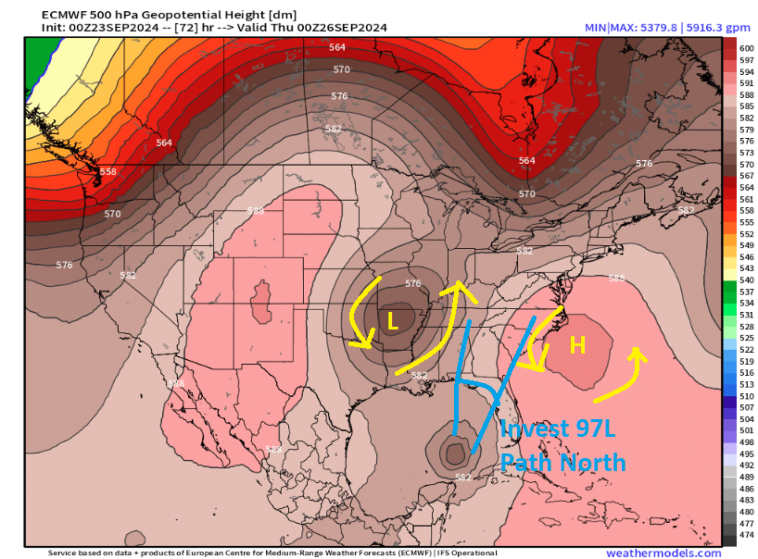
Although we still do not have a clear picture of the center of circulation, it is noteworthy that the forecast models are closely aligned. This indicates a strong confidence in the broader North American weather pattern and the large-scale flow that will steer this developing tropical system northward. The overall steering flow is driven by a cut-off low pressure over the southern plains near the Ozarks region that will pull the system northward. The positioning of this cut-off low will need to be watched as there is a trend for this low to be a bit stronger and deeper, which would provide some early guidance that the system might favor a further eastward track vs. a western track.
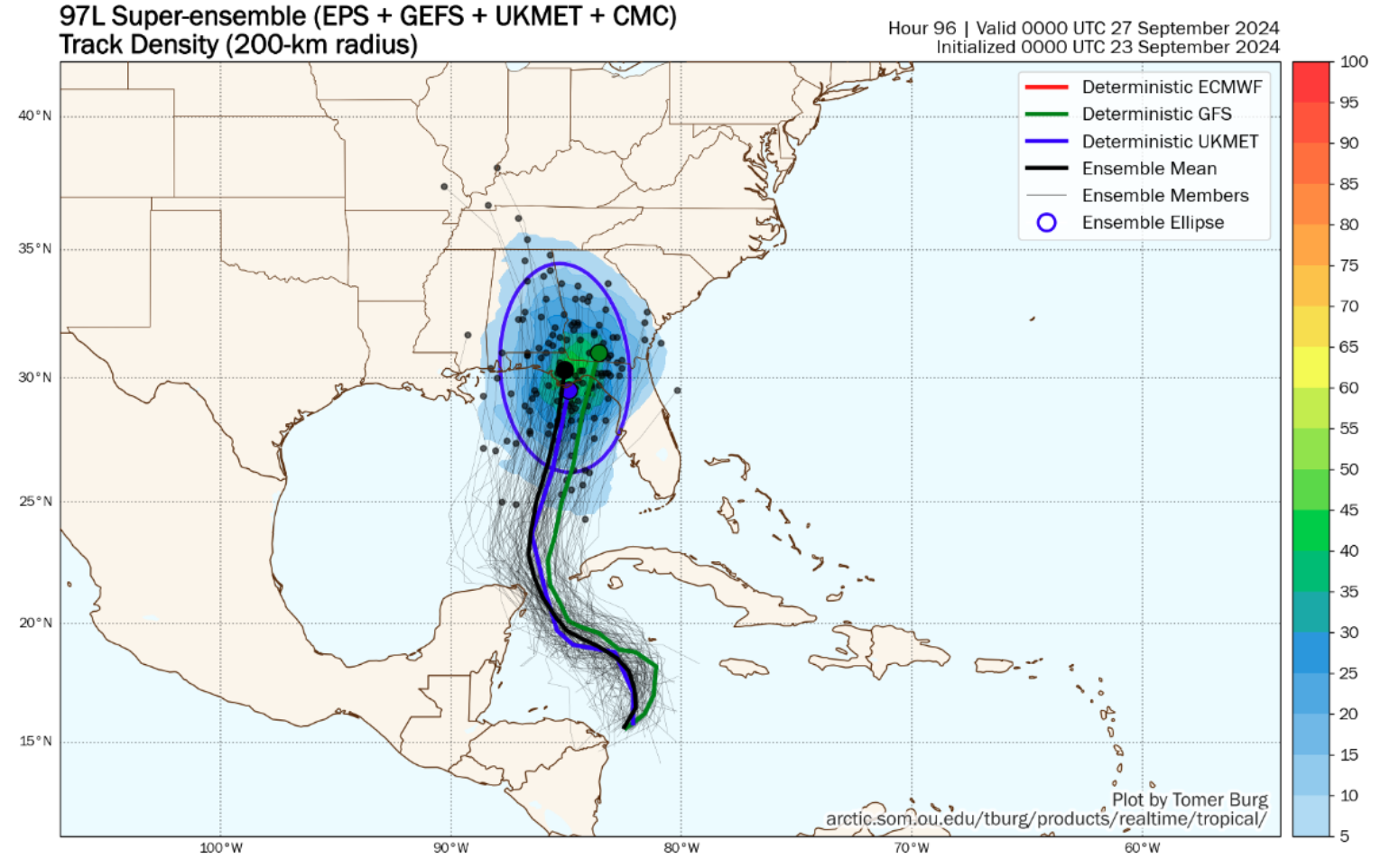
Since there is no official track yet, we can use probability and ensemble to guide the development of this tropical system. Currently, most model guidance is between Panama City Beach, FL, and Steinhatchee, FL. The coastline here is very rural in nature, but the capital city of Tallahassee at this time might be the biggest concern for large insurance impacts, but these ideas could change over the coming two days.
Of course, the track is only half or less of the story, as the size and intensity will truly determine most of the future impacts. One of the current major factors is how fast the system gets a low-level center and develops, remembering we still have yet to have a defined low-level center. The quicker the system comes together, the stronger it will become. There is a chance that the newly formed Tropical Storm John in the East Pacific could provide some wind shear, slowing development over the next day. The size also matters; if the general circulation is large, it will take longer to spin up vs. a smaller circulation. All these factors will impact future storm intensity and storm surge in the future. We do know this areas is very prone to large storm surge due to the shape of the coastline and the bathymetry. The Statistical Hurricane Intensity Prediction Scheme (SHIPS) is very aggressive with the future intensity. This forecast model shows shear of less than 10 knots almost all the way until landfall with plenty of moisture and SSTs in the 86-88 F deg range. In fact, at this time, the system is expected to track right up what is known as the Gulf of Mexico loop current.
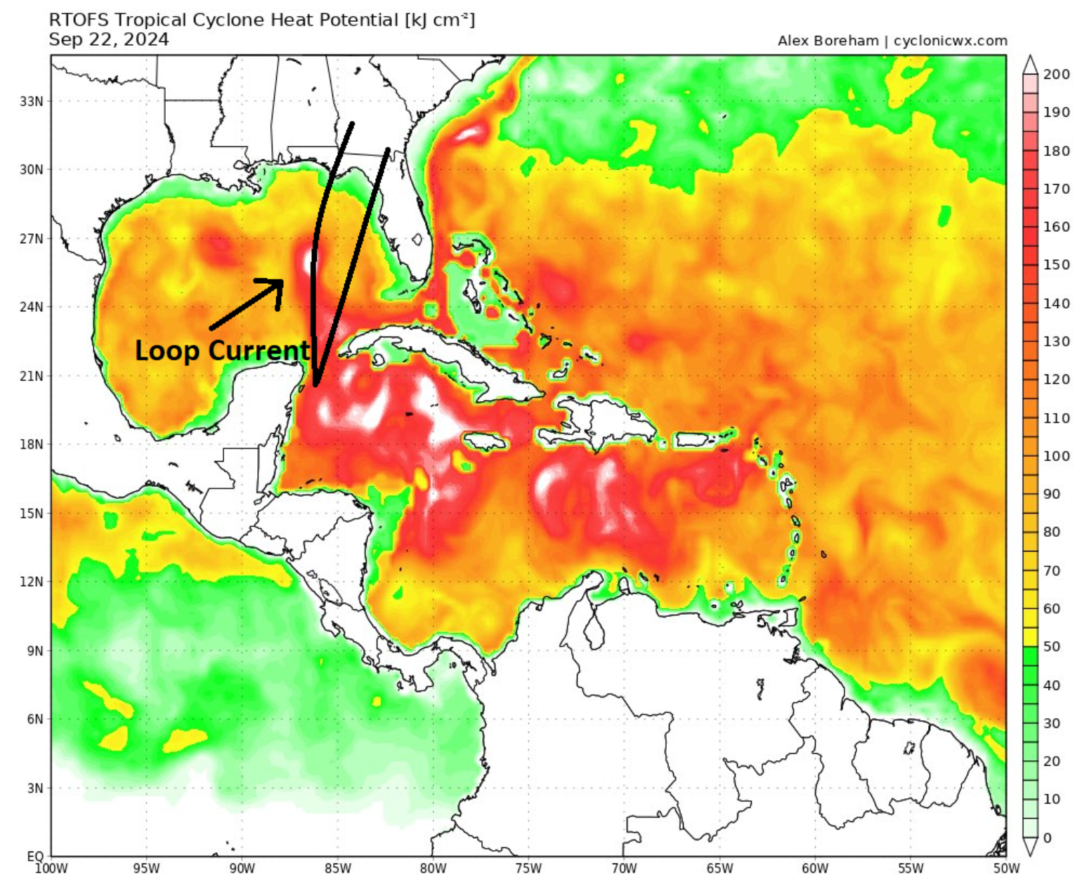
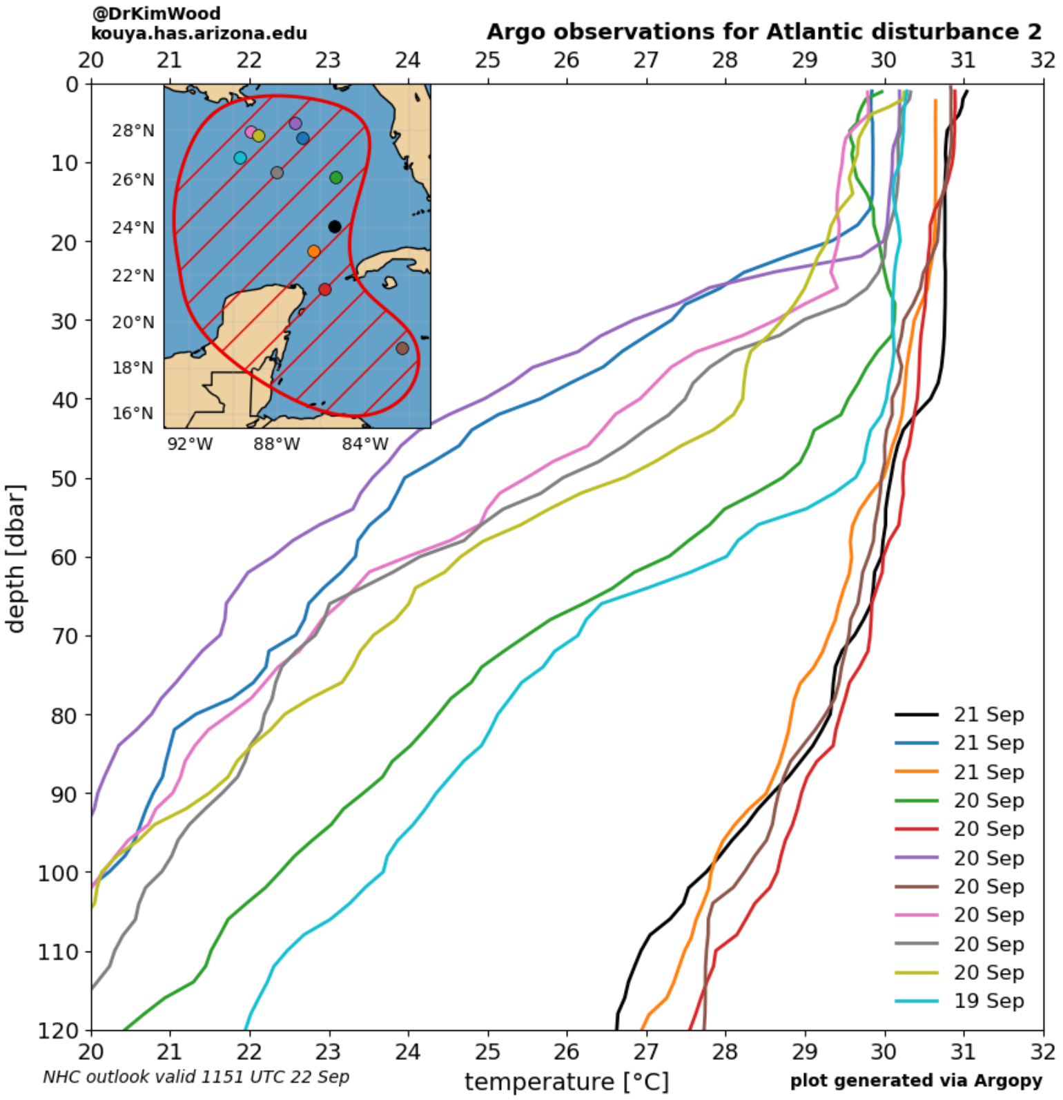
Interestingly, temperature data from Argo float observations generally show above-normal water temperature for this time of year, not just at the surface but also at depth. Lastly, the other factor for intensification is that the upper-level low will provide an upper-level dynamic that will enhance rising motion or (venting) adding in intensification as the system tracks into the Gulf of Mexico. All signs point towards a system that will likely be strengthening right up until landfall, which is not a good sign to see. So although a lot of intensity forecasts are on the table, the forecast is weighted to a stronger hurricane / major hurricane at this time, which adds to the pain point this area has experienced lately.
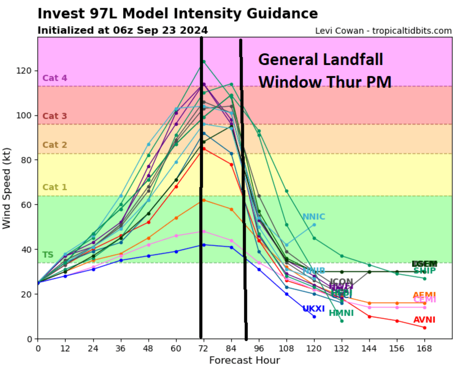
In 2018, Hurricane Michael made landfall as a Category 5 storm in Mexico Beach, marking the beginning of a troubling trend of rapidly developing named storms in the southern Gulf of Mexico. Then, in 2020, the insurance industry faced the impact of Category 4 Hurricane Laura, which struck Louisiana. In 2021, Category 4 Hurricane Ida hit Louisiana. In 2022, Category 5 Hurricane Ian hit Florida as a Category 4. In 2023, Category 4 Idalia hit Florida as a Cat 3. Will another major hurricane strike in the same general areas of the big bend, and what will the insurance impact be? It is too early to tell, but the trend is not good here. The picture will become much more evident in the coming two days, as we know the overall loss will depend on the landfall location. There are some high and low areas of insurance exposure in the current expected landfall area.
So, even though the calendar indicates it is fall, there is still a good chance for tropical weather over the next two weeks. Long-range forecast models also hint at the possibility of more trouble following the latest impact of this system.
