If you are a reader and enjoy the weather, you might have read the book Isaac Storm, “A Man, a Time, and the Deadliest Hurricane in History.” What is interesting in this true story, is the accounts of the weather before the Great 1900 Galveston Hurricane. Before landfall, there were tails of unbearable heat. I am not saying Idalia is heading to New Orleans, but the city had its warmest day in history yesterday at 105F (Records date back to 1946). This historic heat wave on the Gulf Coast has broken dozens of heat-related records. When big hurricanes head north, it seems heat builds ahead of the storm, so this is par for the course; the question is, will a big strong hurricane occur? It is looking very likely for parts of the Big Bend of Florida’s West coast.
Forecast Intensity (Rapid Intensification Possible)
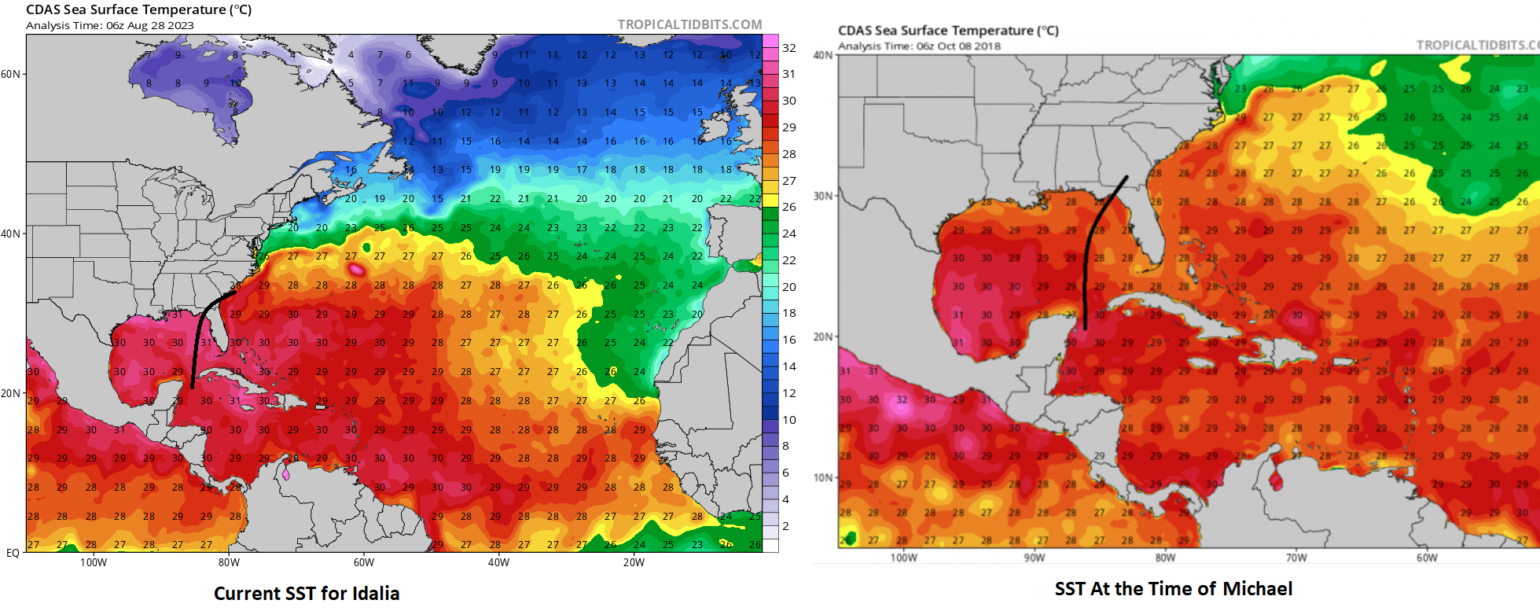
Over the last several BMS Tropical Updates, we have made it abundantly clear that the Ocean Heat Content (OHC), which is a combination of Sea Surface Temperature (SST) and the overall depth of the warm water, can support a powerful hurricane along the projected path. Yesterday, the BMS Tropical Update mentioned some similarities to Idalia's overall position and where Hurricane Michael was in 2018. Looking back at the initial BMS Tropical Updates from 10/08/2018 (yes, we keep an incredible archive so the insurance industry can go back and learn from these past events), readers will notice that the tropical update discussed the current loop, OHC, and SST. Unfortunately, the data analysis tool to compare OHC has changed since 2018, which was used in the 2018 tropical update, but we can still use the same tool to compare Michael SST with the path of Idalia.
The plot below shows the SST for Idalia is a few degrees warmer than Michael, and although not shown the OHC is warmer as well.
However, hurricane intensity is not all about SST and OHC. You need to have the right upper dynamics. Just like Harold last week, which did not explode into a monster hurricane as it crossed the Gulf of Mexico on its way to Texas. Despite the SST's warm, it did not have ideal upper air conditions for development. Idalia is expected to follow a relatively narrow channel of north–north-eastward steering currents that are between an upper low over the Western Gulf of Mexico, a deep trough that is responsible for much of the heat relief this weekend over the Central Plains, and the subtropical ridge over the Southwest Atlantic. These currents will accelerate Idalia north, then north–northeast late Tuesday and early Wednesday. Exactly how these different airmass interacts with Idalia will be critical in determining how strong Idalia will be at landfall.
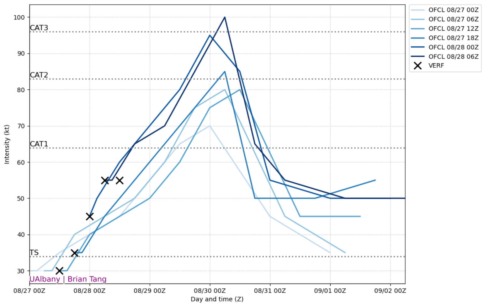
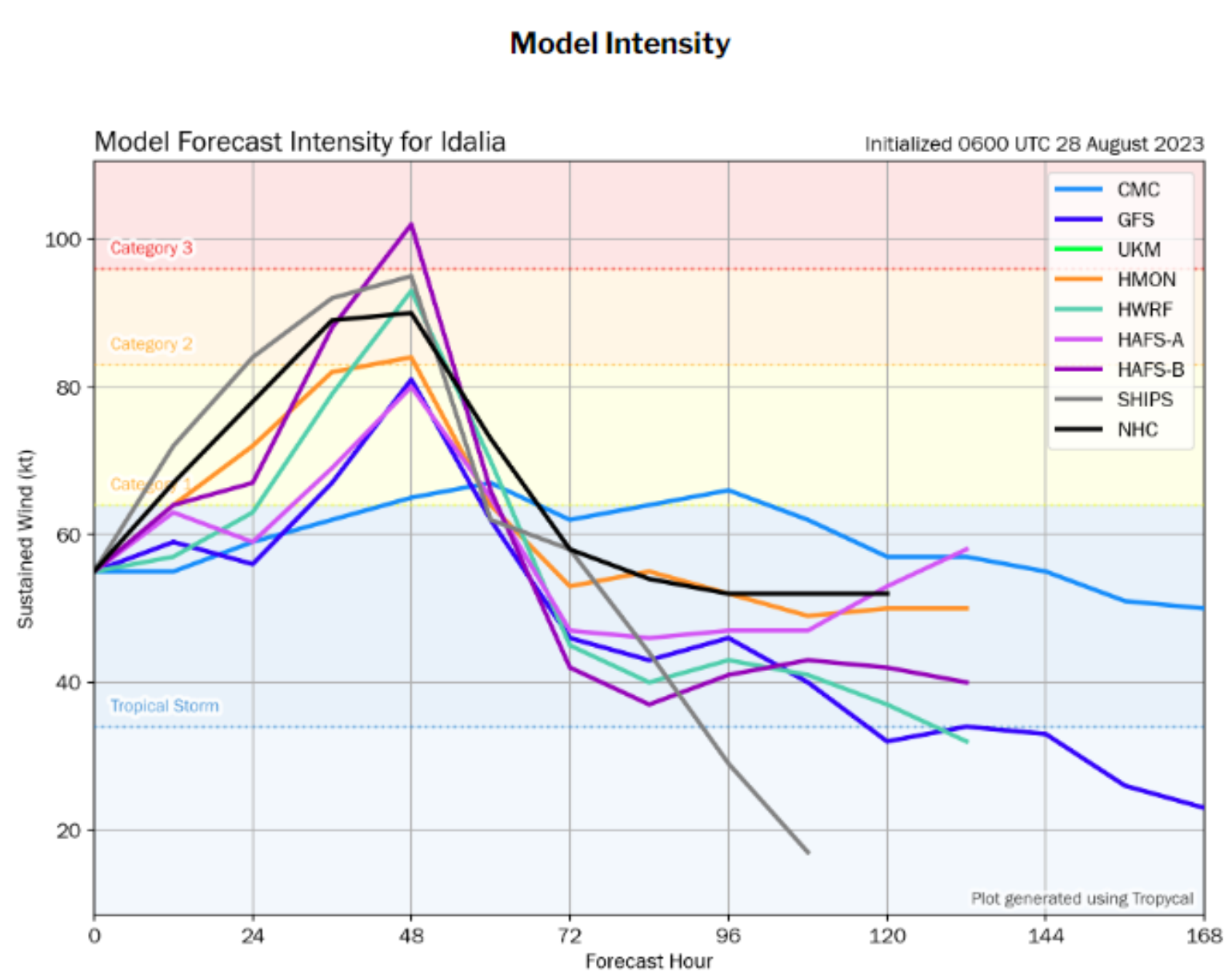
Tuesday will also be crucial as Idalia lifts north and into the East Central Gulf. As this happens, the upper-level winds will begin to ventilate the thunderstorm activity, aiding healthy outflow and likely resulting in rapid intensification (A jump in maximum sustained winds of 35 mph or more in 24 hours). This very favorable upper level will coincide with Idalia crossing over the extremely warm water that has been highlighted above. The only possible factor that might limit some intensity is time over water and dry air that might come into Idalia. This is the wildcard to limit the maximum potential intensity. For this reason, these BMS Tropical updates have been warning about the potential for Idalia to be a major hurricane at landfall. Now, the National Hurricane Center has made that adjustment, and there is still a reason why the adjustment upward could occur, so do not be surprised if that happens over the next two days.
Forecast Track
Thankfully, the overall atmosphere set up is not like Hurricane Ian last year. Since last Friday, there has been a high degree of accuracy that Idalia would be tracking toward the Big Bend Region of Florida. The exact landfall location remains, but it appears there is not the same uncertainty as there was with Hurricane Ian, and a high degree of confidence can be put on the current NHC cone of uncertainty.
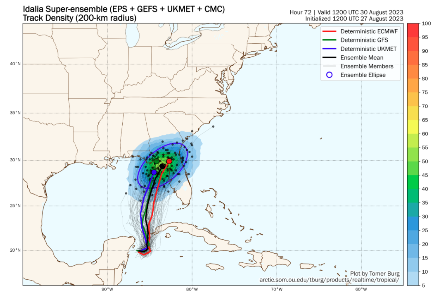
The best way to illustrate the forecast uncertainty at this point is to look at Tomer Brug from the University of Oklahoma Super Ensemble, which plots the ensembles of the ECMWF, GFS, UKMET, and Canadian forecast models (116 different track forecasts). Overall, they are all tightly focused around the same cone of uncertainty that the NHC has currently, and although the Tampa Bay region is in the cone of uncertainty at this time, the probability is 25% - 30%. Though it should be noted impacts from a hurricane can be felt far beyond the cone of uncertainty and one of the major impacts that is likely is storm surge.
Storm Surge Inundation
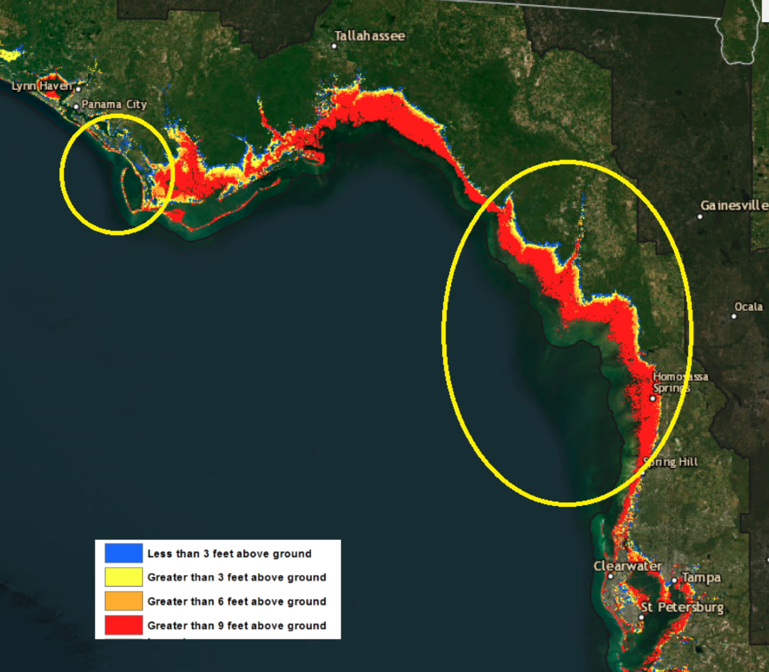
The risk continues to increase for life-threatening storm surge from Idalia as this area of the Florida Gulf Coast has a very shallow continental shelf, which will enhance storm surge impacts. Michael's storm surge was high at over 15 feet but did not surge too deep inland. This will not be the case for Idalia, as the storm surge could go several miles inland due to low-lying areas and swamps along the Big Bend Region of FL. The differences between the two zones are massive in the same hypothetical category, as shown in the Maximum of Maximum products. Thankfully, this has resulted in limited coastal development along the coast, but small communities from Steinhatchee, FL, down to Bay Port, FL, could see some major storm surge inundation. What needs to be watched is any shift in the forecast to the south will be critical to how much storm surge Tampa Bay could receive.
Insurance Industry Loss
As the forecasted track continues to take Idalia into the Big Bend region of Florida between Steinhatchee, FL, and Cedar Key, FL, it has been a real task to find an analog storm to help understand historical impacts. Remarkably, this area has been hurricane-lucky, with very few hurricanes tracking within 60 miles of Suwannee, FL, which seems to be the current focal point for landfall. This focal point will likely change, but as stated, the forecast models have been relatively consistent with the track forecast. According to the NOAA historical hurricane tracks, only 13 hurricanes have made landfall within this radius, and it is even rarer to see a major hurricane in this area, with only two making landfall in the historical record. These two were Unnamed Storm of 1896 and Easy of 1950. This results in some of the longest return periods for a major hurricane outside the Northeast coastline. With areas of the Big Bend of Florida having a return period of a major hurricane every 30 – 45 years.
What does this mean? This means plenty of untested homes, businesses, trees, power poles, and people. Most of these residents were not alive the last time an intense hurricane made landfall in this region—however, the good news for the insurance industry is the Big Bend area of Florida is mostly swamp and wildlife management areas until you get down to Crystal River, FL. The general area has a low population density, so the overall industry insurance exposure is lower, which will limit top-end loss. At this point, without suitable analogs, more research needs to be done into catastrophe modelling scenarios to get a better picture of loss. This will be provided tomorrow as the track uncertainty starts to narrow, and the industry can hopefully take some of the larger loss scenarios off the table, which would involve the Tampa Bay Metro area. Until then, the loss range is wide given this possible ensemble scenario of a 30% chance of Tampa Metro area impact. These loss scenarios are pretty eye-opening, which means the next 24 hours are critical to see what the ultimate track for Idalia will be so the industry impacts can be tuned the impacts. Regardless, a major hurricane into any section of Florida that extends into the Southeast states is likely a multi-billion dollar insurance industry event.
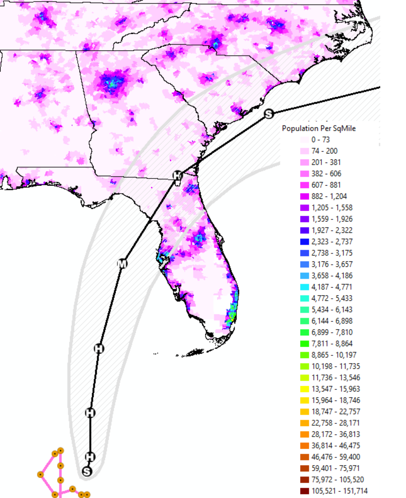
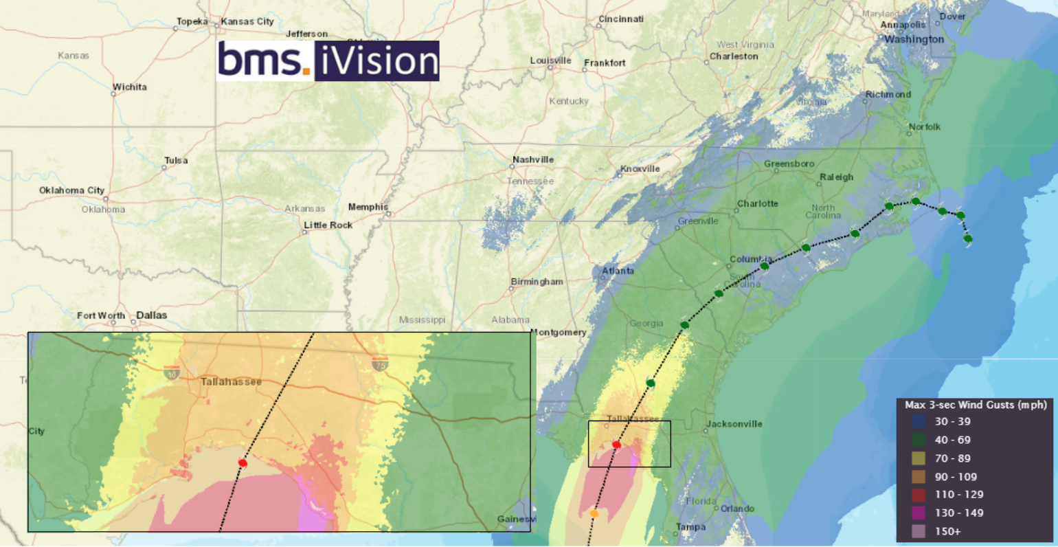
The last few BMS Tropical updates have focused on Florida impacts, and for good reason; there is now some clarity as to impacts that might be felt to points further north. First, given the expected intensity, a swath of strong winds will occur across the state, as shown in our BMS iVision wind swath above. The other areas of concern will be inland flooding as Idalia interacts with a frontal boundary. Ultimately, the hazards depend upon the track taken by Idalia, but the possibility of a significant inland flood event exists Wednesday into Thursday across parts of the Mid-Atlantic, especially the Carolinas. The best example of the possible flooding in the Southeast would be Hurricane Matthew, which caused substantial inland flooding across the Carolinas in October 2016. Extreme rainfall occurred as the storm phased with a frontal boundary. Matthew took a right-hand hook off the US Southeast coast, much like what might happen with Idalia. In fact, almost every recent hurricane has had a flooding story beyond the storm surge, and Idalia could be in the Carolinas.
Bottom Line:
• Idalia means business and will likely rapidly Intensify toward the coastline;
• The National Hurricane Center and forecast are following a trend of increased intensity at landfall;
• Track uncertainty is lower than with Ian last year, focused on the Big Bend Region of Florida Gulf Coast
• Watch for major flooding in the Carolinas.
