BMS Tropical Update 08/27/2023
Sunday weekend BMS Tropical Update on the serious situation developing in the southern Gulf of Mexico as highlighted in the last BMS Tropical Update issued on Friday. At this point, Tropical Storm Idalia has developed, and this has historical significance, which will be discussed at the end of this update.
First, the insurance industry can't forget about Hurricane Franklin, which will likely track west of the insurance hub of Bermuda as a major hurricane. An upper trough will pull Franklin and force it to accelerate to the Northeast as it gradually weakens in the northern Atlantic. Franklin should stay far enough west of Bermuda so that no insurance impacts will be felt from Franklin besides possible flight disruptions and big surf around the island.
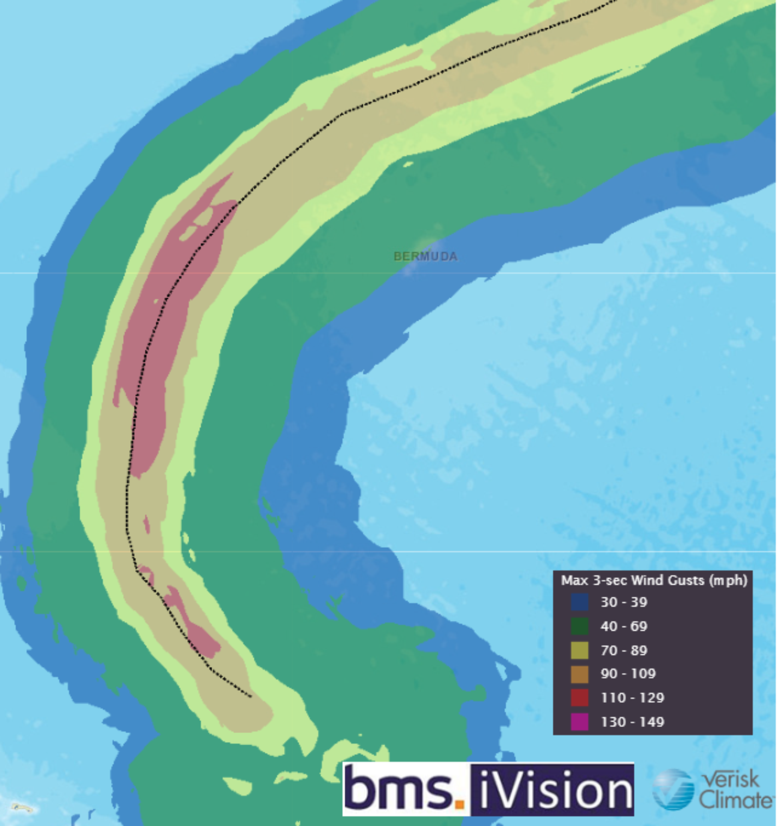
Expected Intensity of Idalia
The main focus for the insurance industry needs to be Tropical Storm Idalia. This system continues to meander around the island of Cozumel, Mexico, meaning it has stayed over the open water, which is concerning. This is just west of the area where Hurricane Michael formed in 2018, and the insurance industry can't forget how fast Michael strengthened on its way north to the Panhandle of Florida in early October.
Tropical Storm Idalia should start moving north over the Gulf later today. The situation is undoubtedly evolving, especially the intensity estimates as time passes. As we pointed out on Friday, the tropical system will move into a favorable environment consisting of deep Ocean Heat Content (OHC), warm Sea Surface Temperatures (SST), and minimal dry air. The other factor is that a trough will dig down into the central U.S. and northwest Gulf Of Mexico, where it will pull Idalia north but also travel in the same direction the shear vectors are oriented, allowing for enhanced outflow and divergence aloft, all of which can enhance intensity. The only limiting factor in any intensity is dry air intrusions associated with the trough; However, if the Idalia is strong enough, it could fight off the dry air.
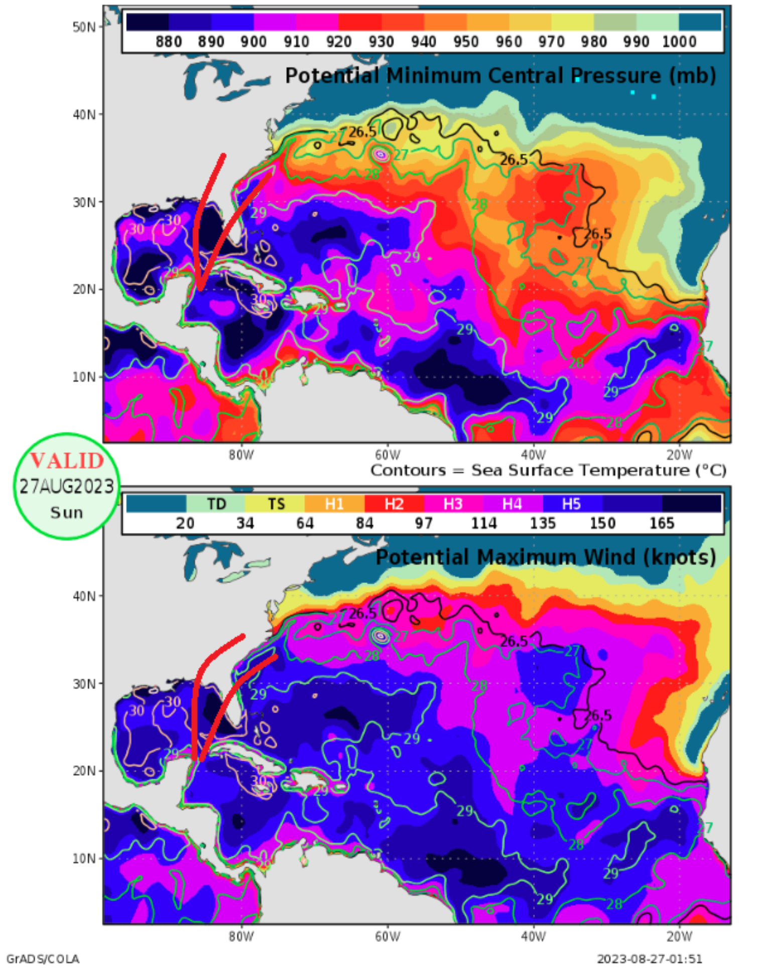
On Friday, the tropical update showed that this tropical system would be tracking over large areas of high Ocean Heat Content that considers not just the Sea Surface Temperatures but the depth of this warm water. In 1996, known hurricane scientist Kerry Emanuel developed Hurricane Potential Intensity Maps (shown above), which guide perfect conditions regarding the maximum potential intensity of a storm over given waters. The latest values suggest the sky is the limit for intensity as the storm tracks over some of the highest areas of potential intensity in the Atlantic Basin in the eastern Gulf of Mexico.
The specific hurricane models have been calling out rapid intensification up to landfall. Overnight, the hurricane-specific model, which can be on the bullish side of intensity, calls for the following intensities at landfall. (Ian was 150 mph at landfall with a landfall pressure of 941 mb)
HWRF: 150 mph H4 HMON: 125 mph H3 HAFS-A 165 mph H5 HAFS-B 145 mph H4
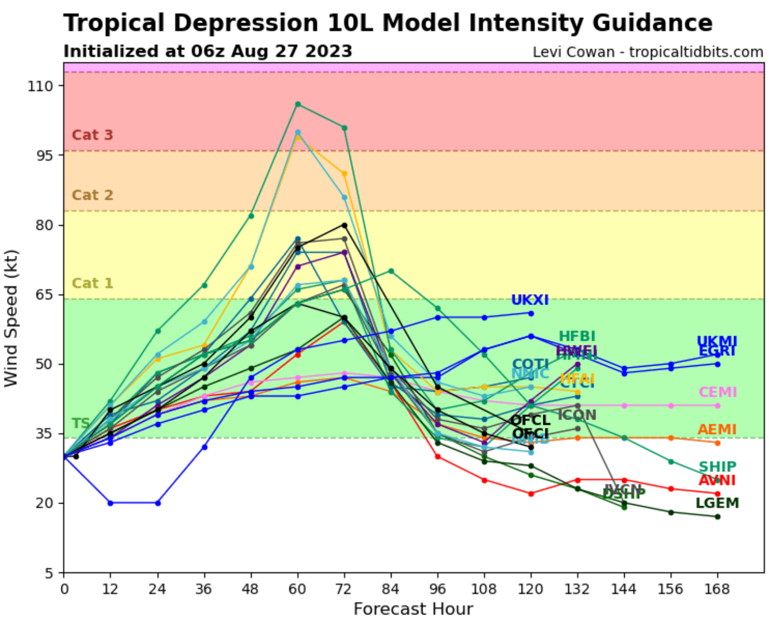
Above is the latest intensity guidance from this morning's various forecast models for intensity guidance. So that you know, some of the hurricane models are not part of this intensity guidance. (Source TropicalTidbits.com)
Idalia Forecasted Track
So, with this and the guidance moving in favor of a major hurricane at landfall around Wednesday morning local time, major impacts now need to be considered for the expected landfall areas, which are focused on the Big Bend Region of Western Florida. However, as we saw with Ian last year, which was right on the Southern edge of the National Hurricane Center (NHC) cone of uncertainty, remember the cone is formed by connecting a set of circles along the forecast track and is intended to give an idea of the historical likelihood that the storm's center will stay inside the cone. The cone is formed based on a two-thirds chance that the storm's center will be inside the cone. That also means there is a one-third chance it will fall outside the cone. This year, the cone size for the 72 hours (3 days) is 99 miles.
As the Tropical Update on Friday suggested, the ECWMF ensemble guidance, which many members now show a hurricane to major hurricane at landfall, follows the NHC cone of uncertainty. It is also an important thing to note. A stronger, fast-moving Hurricane will have serious impacts inland. Intensifying storms don't lose much punch that are moving fast. So don't just focus on the 'landfall' as inland areas will also have some significant impact. If there is any good news in general, the Big Bend portion of Florida has some of the lowest households per square mile across the state, which would limit the upside of a larger insurance industry loss.
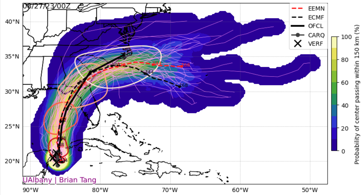
Above is the probability of the ECMWF Ensemble (51 different forecasts showing the highest probability at this time is the Big Bend Region of Florida.
Landfall Impact
Along the coastline, if Idalia makes landfall in the Big Bend area, it is not as developed, as the coastal development does not get concentrated until Crystal River, FL / Homosassa Spring, FL, and points south. However, the sea floor's slope and the increasing full moon on August 1st will enhance storm surge in this region, so storm surges of up to 5 or 6 feet above normal high tides can be expected. Given the possible strength, disruptions across North Florida are possible, which will be power outages, trees down, and mobile homes, in particular, are vulnerable. This kind of system can spawn tornadoes as well.
At this time, it looks like Idaila will stay inland, but this also means it will provide heavy rain and maybe some gusty winds, but nothing worse than we've already had this summer during thunderstorms, only a bit longer duration. If Idaila stays overland, it will create an onshore flow, so areas along the coast could have coast flooding again added by high tides –associated with the full moon.
It is too early to start looking at analog storms and what the expected insurance industry loss might be, as there is too much uncertainty at this point on the potential track and intensity, both of which currently drive a wide range of expected losses for the insurance industry.
Why the "I" storm is important
The number of retired Atlantic "I" tropical cyclone names is partially owing to seasonality - "I" storms currently tend to occur in late August and September when tropical cyclones are more likely to be more intense. This is also partially coincidental. For example, the number of retired "I" Atlantic names (13) is greater than the sum of retired "H" names (6) and "J" names (5), even though all these storms occur at about the same time in a given season. The letter with the second-most retired Atlantic hurricane names is "F," with 10. The third most is "C," with 9, and also strangely, there has been only one retired "C" name since 2001 (Charley, 2004). Also strange is that 11 of the 13 storms (85%) that prompted the retirement of an "I" name occurred in 2001 or later. Atlantic tropical cyclones were first named internally in 1947, and these names were publicly shared beginning in 1950.
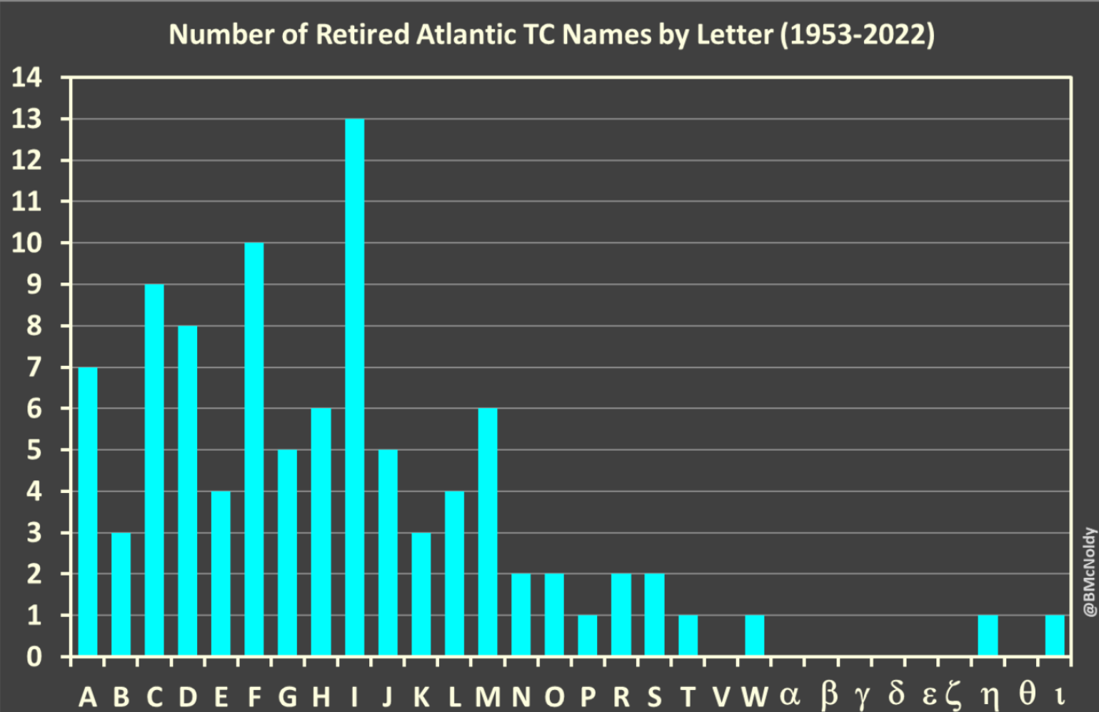
Brian McNold produced this plot from the University Of Miami Rosenstel School.
This BMS Tropical Update is not saying Idalia will be retired. It is saying to take Idalia seriously as not only is there a historical precedent, but the atmospheric condition suggests this storm will leave its mark upon landfall, given the forecast intensity is increasing. Now is the time to prepare, and maybe a coincidence this weekend, the second round of sale tax holidays for the State of Florida for qualified items, many of which are for disaster preparedness.
