Beryl's journey, now nearing its end after nine days, has been a significant one. It has set numerous records, making 2024 the most active start to a hurricane season in terms of the Accumulated Cyclone Energy Index (ACE), with a staggering 34 points. This surpasses the ACE of any storm from the busy 2020 season and even the entirety of the five quietest seasons since 1950.
Beryl’s Remaining Hours Before Landfall
Over the last 2024 hours, there has been a slight shift in Beryl's expected landfall location, bringing the overall impacts closer to the Houston metro area on Monday morning. Overall, after struggling with dry air and shear after exiting the Yucatan Peninsula, Beryl finally seems to be moving into an environment that will allow for some intensification before landfall as frictional convergence, upper-level jet stream dynamics interaction, and with less wind shear work to intensify Beryl at landfall. Beryl could still be dealing with dry air, which seems to be one of the question marks as to how much Beryl will intensify before landfall. So far, dry air and shear have prevented Beryl from intensifying, although it has been plenty of time over the warm Gulf of Mexico water. Beryl will be a modest category 1 hurricane at landfall, but the National Hurricane Center (NHC) guidance is on the higher side of most model guidance.
While it seems unlikely that Beryl will rapidly intensify before landfall, one of the forecast models, the SHIP model, suggests this could happen. However, time is running out. As Beryl is now within 24 hours of landfall, the average National Hurricane Center (NHC) track error is about 30 – 50 miles, and the average intensity error is close to one category. However, it's important to note that the NHC product is just for the expected track and intensity of the storm, and the impacts will be far beyond this 30-50-mile swath that the cone of uncertainty shows.
Beryl’s Landfall Impacts
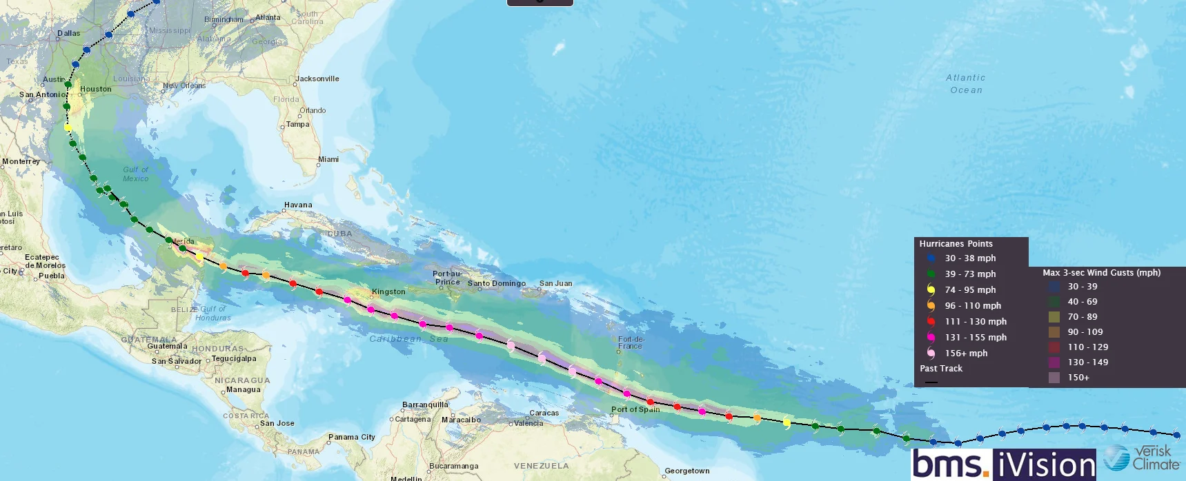
As mentioned above, the impacts will be far beyond the NHC cone of uncertainty. For example, the wind impacts can be seen in our BMS iVision Verisk Respond product below. As typical, the strongest winds will be on the right side of the storm, and it shows that 70 mph wind gusts could extend up to Galveston, TX about 100 miles northeast of the expected landfall location. It is expected that the worst of the winds will be in the Freeport, Lake Jackson, and Angleton areas to the southwest of Houston. However, it should be noted most structures and roofs should be able to withstand this type of sustained winds, especially given the named storm frequency that has impacted along this section of the Texas coastline.

Due to Beryl's smaller size, storm surge should not be a big issue, but as experienced in Tropical Storm Alberto in the middle of June, the Texas coastline can easily experience storm surge flooding, and a similar storm surge is expected with Beryl, but will be more limited in geographic scope, with most areas expected to see less than 3 ft of storm surge. Still, isolated pockets of 6 ft. Using the high-resolution storm surge inundation map product from the NHC it is recommended to determine the areas with the most impact. As a reminder, Beryl's expected landfall section is very rural. Most of the storm surge is within the intertidal zone, so make sure to have this layer on to see the true impacts of storm surge on non-intertidal areas, but also note most of the structures right along the coastline have been elevated to a heights of 6- 10 feet above the ground to prevent storm surge flooding. The worst of the storm surge is expected between Mesquite Bay and San Luis Pass, Texas, and Matagorda Bay, with a 4-6 feet storm surge.
A few hundred miles away yesterday, a thunderstorm caused Houston to have a flooding problem. This city has a major flooding problem. Urban development has added impervious surfaces, intensifying runoff with excessive rainfall, which seems to always cause problems for the Houston metro area. As Beryl comes further north, more intense rainfall is expected, worsening existing flooding issues.
Currently, the heaviest rain will fall on the right side of Beryl track inland, and as we mentioned yesterday, this is not a repeat of Harvey (2017). Still, Heavy rainfall of 5 to 10 inches with localized amounts of 15 inches is expected across portions of the middle and upper Texas Gulf Coast and eastern Texas. This will no doubt cause problems with flash and urban flooding, as we have seen time and time again in the Houston areas, and of course, the area is still recovering from flooding from the potential Livingston Dam failure earlier this year.In addition to the locally heavy rainfall, brief tornadoes will be possible within the rainbands beginning this afternoon, potentially continuing through Monday as Beryl makes landfall.
After Beryl moves inland, the latest forecast shows the system accelerating farther northeastward, ultimately phasing with a mid-latitude trough over the Ohio Valley while transitioning into a post-tropical cyclone. This could create some stormy weather for the early part of the week, but nothing that should lead to large insurance industry losses to states further inland.
Beryl Expected Insurance Industry Impacts
With Beryl now less than 24 hours before landfall, it is clear that time is running out on how much Beryl can intensify before making landfall in a very rural part of the Texas coastline, which will be welcome news for the insurance industry limiting overall insured loss. Matagorda County and Brazoria County, Texas, which is the current expected landfall county locations of Beryl, in between Freeport, Texas, and Rockport, Texas, only has a population of 435,297 people.
As pointed out in our tropical update yesterday, this section of the central Texas coastline is no stranger to named storm activity. The general area gets brushed or impacted by a named storm every 2.7 years, and the average for a hurricane landfall is about every 9.5 years. Since 1900, BMS estimates that 208 hurricanes have made landfall in the U.S. 51 (24.5%) have tracked over Texas as a hurricane. Of the 51 hurricanes, 23 have occurred since 1950, but Texas has never had a Category 5 landfall.
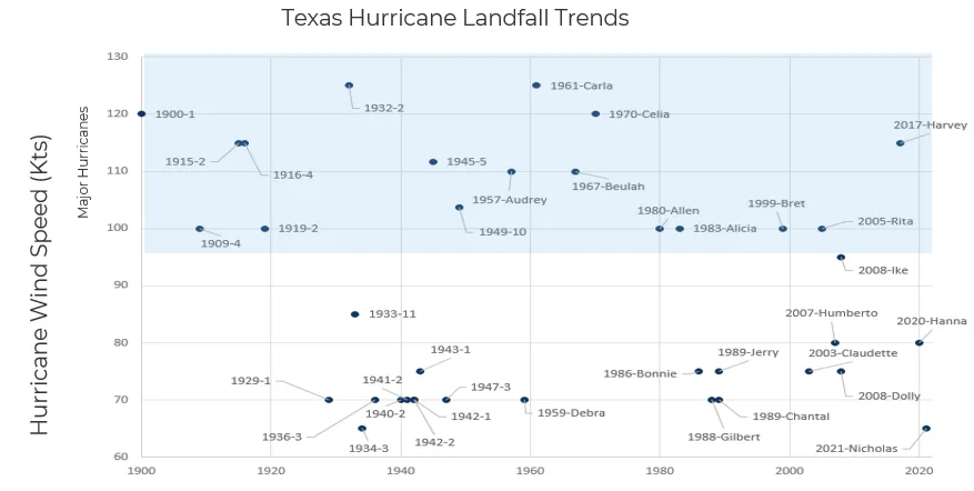
Above is the trend of Texas hurricane landfalls, which show no definite long-term trends across the state. The period from the mid-1930s to the late 1940s was an active landfall period for the state. As Beryl makes landfall as a category 1 hurricane, it will align with what is expected for the state and this section of the Texas coastline. In that BMS Tropical update yesterday, based on their analogs and a review of some of the catastrophe risk modeling stochastic tracks BMS has selected, it would appear that overall insured loss will likely be sub $500M if Beryl makes landfall in the expected rural areas between Freeport, Texas, and Rockport, Texas, as a category 1 hurricane. This means the event will likely be a retained event for most insurance carriers and have little to no impact on the reinsurance industry.
The worst storm impacts on the current expected track should fall between Port O’Connor and Freeport, Texas. Beryl should cause light damage, power disruptions, and down trees but is not likely to be near catastrophic. The biggest risks are waves and storm surge flooding on the coast and river and flash flooding inland near Houston.
Tomorrow, there will be one last Tropical Update on Beryl. This update will likely focus more on what to expect for the month of July, which looks very quiet until the first week of August.