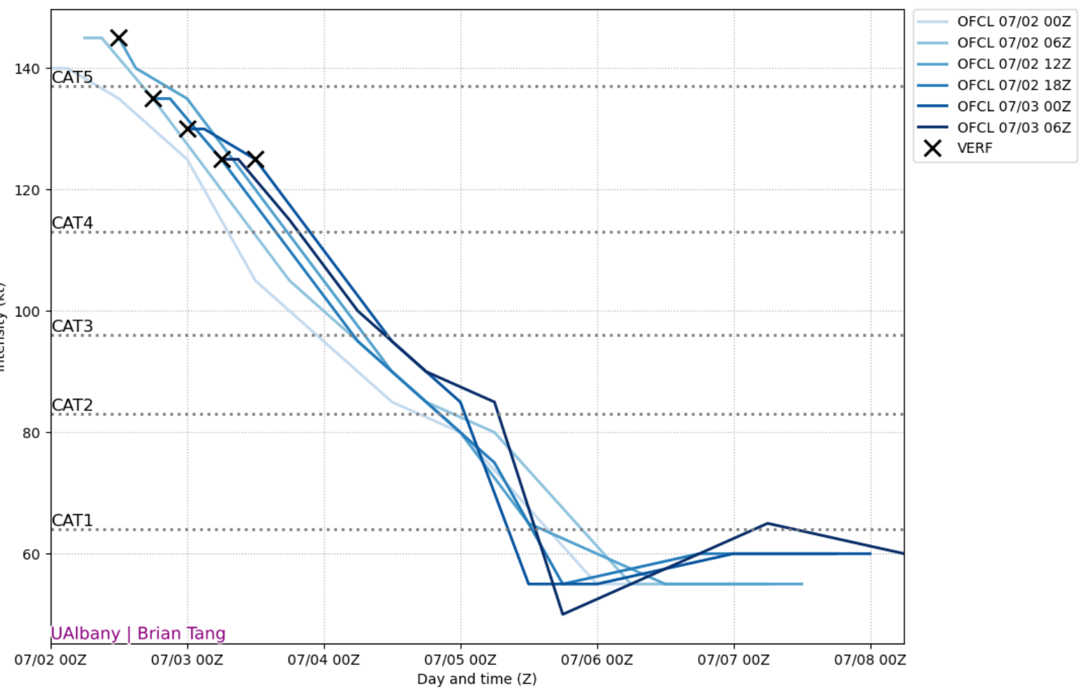
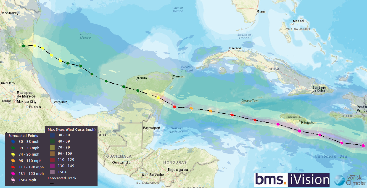
After taking a day and a half tracking across the central Caribbean Sea as a major hurricane, Major Beryl is starting to weaken slightly due to the increase in wind shear that was discussed in our Tropical Update yesterday. However, this weakening is not occurring fast enough to protect the island nation of Jamaica, which, over the next 12 hours or so, will be facing the impacts of Beryl's strongest winds that occur on the right front quadrant of the storm. This specific quadrant contains the greatest storm surge and strongest winds, usually along with the side of the storm with the most tornado potential. At this point, Hurricane Beryl seems to defy all expectations. Even under moderate to high wind shear late yesterday and into the night, it remained a powerful Category 4 hurricane, which is several miles per hour more robust than what was forecasted yesterday by the National Hurricane Center. Unfortunately, these intensity forecast challenges will continue for the next several days.
Jamaica Impacts
While a direct landfall on Jamaica is not the most likely scenario, it cannot be ruled out. The last major hurricane to make landfall on Jamaica was Hurricane Gilbert in 1988, as a Category 3 hurricane. Hurricane Beryl is projected to pass just south or over Jamaica later today, making it the most powerful hurricane to affect the island in 17 years (since Hurricane Dean in 2007). Here is a list of all Category 3+ hurricanes that have come within 50 miles of Jamaica.
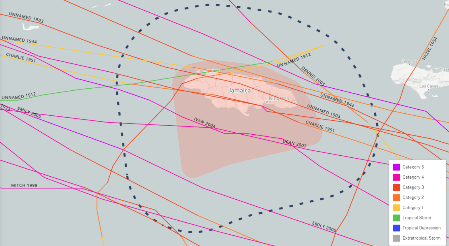
Unlike some of the smaller Windward Islands that Beryl has already impacted, Jamacia's impacts will be much different. One might believe that the impact on the smaller Windward Islands is greater due to their small size and the damage relative to the overall GDP of the island size. Jamaica is a much larger island with a much larger GDP, so only a tiny portion of the island will see the most severe impacts of Beryl. However, looking at some of the historical losses can help provide an accurate depiction of what could be expected in terms of loss from Beryl. According to the EM-DAT data, if Gilbert were to occur today, it would cause $2.5B of economic loss. Dean in 2008 would cause $420M in economic loss. Some other notable recent losses would be Ivan in 2004, which would result in $920M in loss, and Charley in 2004, at $270M. The estimated GDP of Jamaica is $17B. So, with the understanding that the protection gap could be quite large for the island of Jamaica, insurance industry losses would be a fraction of these values. Beryl will likely cause a couple hundred million dollars of loss as it impacts the island nation today.
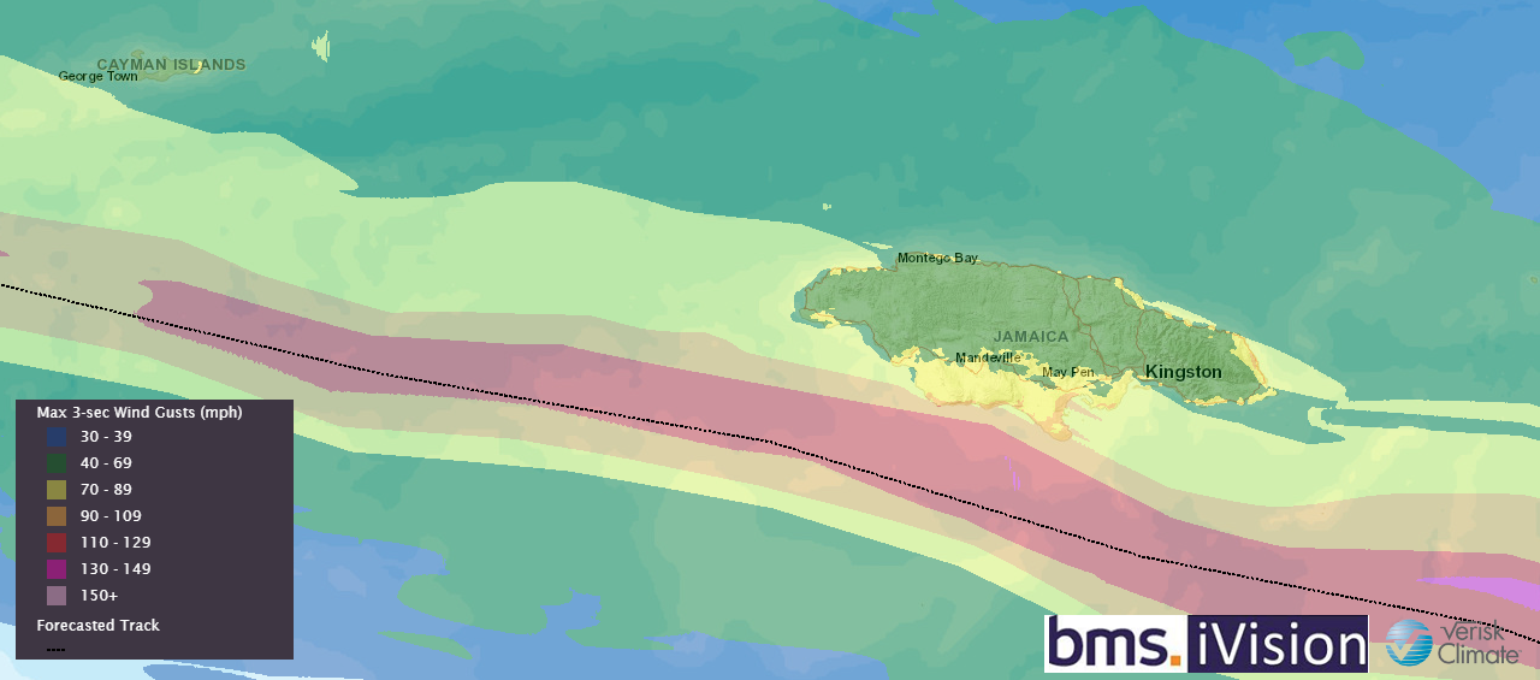
A primary concern is that Jamaica has very tall mountains, which will likely produce major flash flooding across much of the islands, so the impacts will not be just coastal in nature. Landsides are also possible as much as 30 inches of rain is forecasted over the higher terrain of the island. Although most of the coastline is relatively steep, the small bays and inlets, particularly on the island's eastern side, could see storm surges of six to nine feet. Given the complex terrain, the winds will be erratic. Still, the major population center of Kingston will likely see wind gusts of 70 mph, and a large part of the population lives in fragile shantytown-type structures with no insurance.
Cayman Islands Impacts
At this time, the impacts to the Cayman Islands appear minimal, but some storm surges and strong gusty winds could be expected as Beryl passes about 70 miles to the south of George Town in the early morning hours of July 4th. Very little insurance loss is expected from Beryl's result.
Future of Beryl Intensity and Track
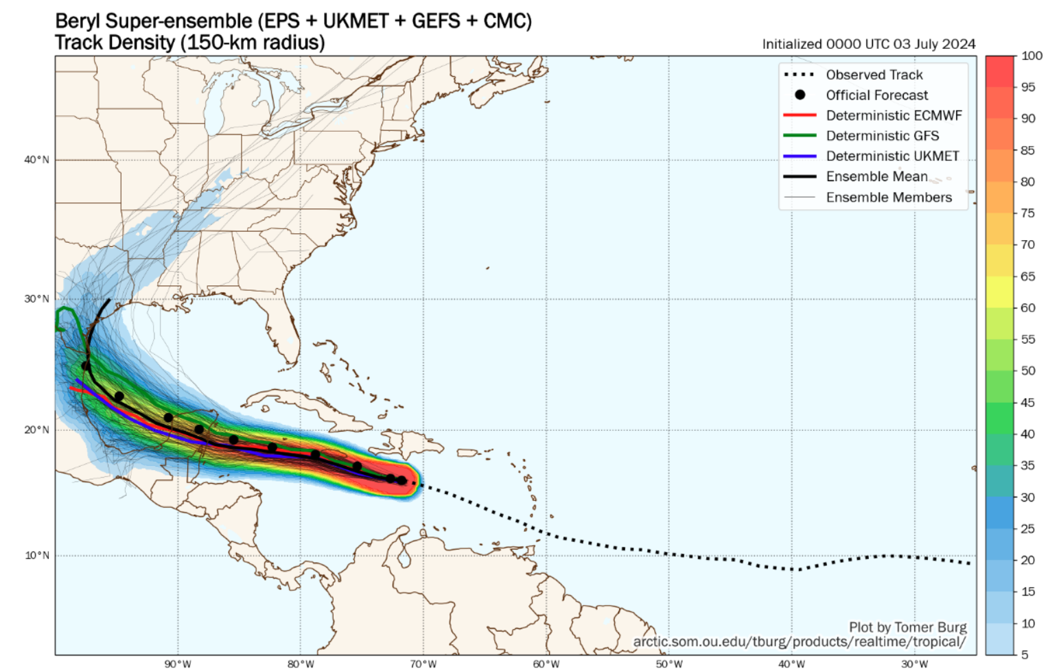
Over the last few BMS Tropical Updates, we have highlighted the uncertainties in the long-range forecast, particularly the use of the ensemble models and how the mean can be deceiving due to the number of members that drop off as Beryl weakens over the Yucatan. However, given how close Beryl will track to Jamaica's mountainous terrain, these too could also impact Beryl’s overall structure as a hurricane. These mountains have the ability to disrupt the wind field, and it is possible that it could impact Beryl's future track and intensity. Suppose Beryl is disrupted more by Jamaica and is weaker. In that case, it will take a more southern track and be weaker when it impacts the Mexican coastline, likely meaning it would have a much harder time regaining strength in the southern Gulf of Mexico. However, as highlighted, Beryl seems to be exceeding expectations in terms of intensity. Although wind shear will continue to be high over the next day as Beryl continues to move across the Caribbean Sea on Thursday, it will interact with *extremely high* ocean heat content. As a result, this might be a rare case where the wind shear and high ocean heat content equal other to maintain a moderate hurricane of Category 2 or 3 straight as it makes landfall near Tulum, Mexico, in the early morning hours of July 5th. However, outside of some major resorts that could impact the insurance markets, the general population in these areas is relatively low.
Beryl is expected to emerge into the southern Gulf of Mexico on Friday night. After that, various outcomes remain possible, such as a second landfall in Mexico or along the U.S. Gulf Coast late this weekend. More than a handful of ECMWF ensembles curve from Texas to Louisiana into the U.S. Gulf Coast. Nonetheless, this number is about 20% of the total. Therefore, at this time, there is a probability of U.S. insurance industry impacts at about 40% across Texas, with the likelihood of Louisiana still at 5%, as suggested yesterday.
Looking Ahead Past Beryl
To avoid downplaying any future impacts of Beryl as the book is still being written, there is some positive news for the insurance industry beyond Beryl's end story. Although Beryl has generated the 3rd-most Accumulated Cyclone Energy on record through July 2nd, trailing 1886 and 1951, the long-range climate forecast models show the Atlantic basin will be void of activity for most of the middle part of July. This will be welcome news to the insurance industry, with any hit of major Atlantic Basin Hurricane activity coming at the end of the month as the upper-level convective force moves back over the basin.
With all this in mind, let us remind ourselves that the tropics are tranquil globally overall. While the Atlantic has been extremely busy lately, the eastern North Pacific has yet to have its first named storm. This puts that basin at its latest start in the eastern North Pacific hurricane season in the satellite era since 1966.
