As we posted yesterday in our BMS Tropical Update, there was a possibility that Beryl would reach a Category 5 hurricane status, a feat it ended up achieving last night. Category 5 hurricanes in the Atlantic Basin, any time a month, are exceedingly rare having occurred only 41 other times since 1851. Our blog yesterday highlighted how we have much better observational capabilities now, and if you have not checked out any of Beryl’s satellite images, now would be a good time to see the classic structure of a Category 5 hurricane. Beryl winds are, however, intense, but the overall pressure of 938 mb makes it one of the highest pressures recorded for a Category 5 hurricane. As you might have read, research suggests pressure is a much better indicator of potential damage than the estimated wind speed. Thankfully, Beryl's extreme intensity is not impacting anything as it crosses the central Caribbean about 235 miles south of the Dominican Republic. In other words, there is little damage occurring now as it crosses very warm water as it reaches the theoretical Maximum Potential Intensity (MPI), which is something that happens extremely infrequently in the historical record. Yet, when the conditions are perfect like with Beryl, this is possible just as science says.
Beryl Impacts Thus Far
Beryl continues to break all sorts of records.
- 1st Category 4 on record for June
- Earliest Category 4 on record, 3rd earliest major hurricane
- Farthest east, a June hurricane has formed
- Earliest Rapid Intensification from a TD to a Major Hurricane
- Strongest Eastern Caribbean hurricane since Maria in 2017
- Strongest hurricane this early in calendar year on record. Ahead of Emily 2005 by 15 days
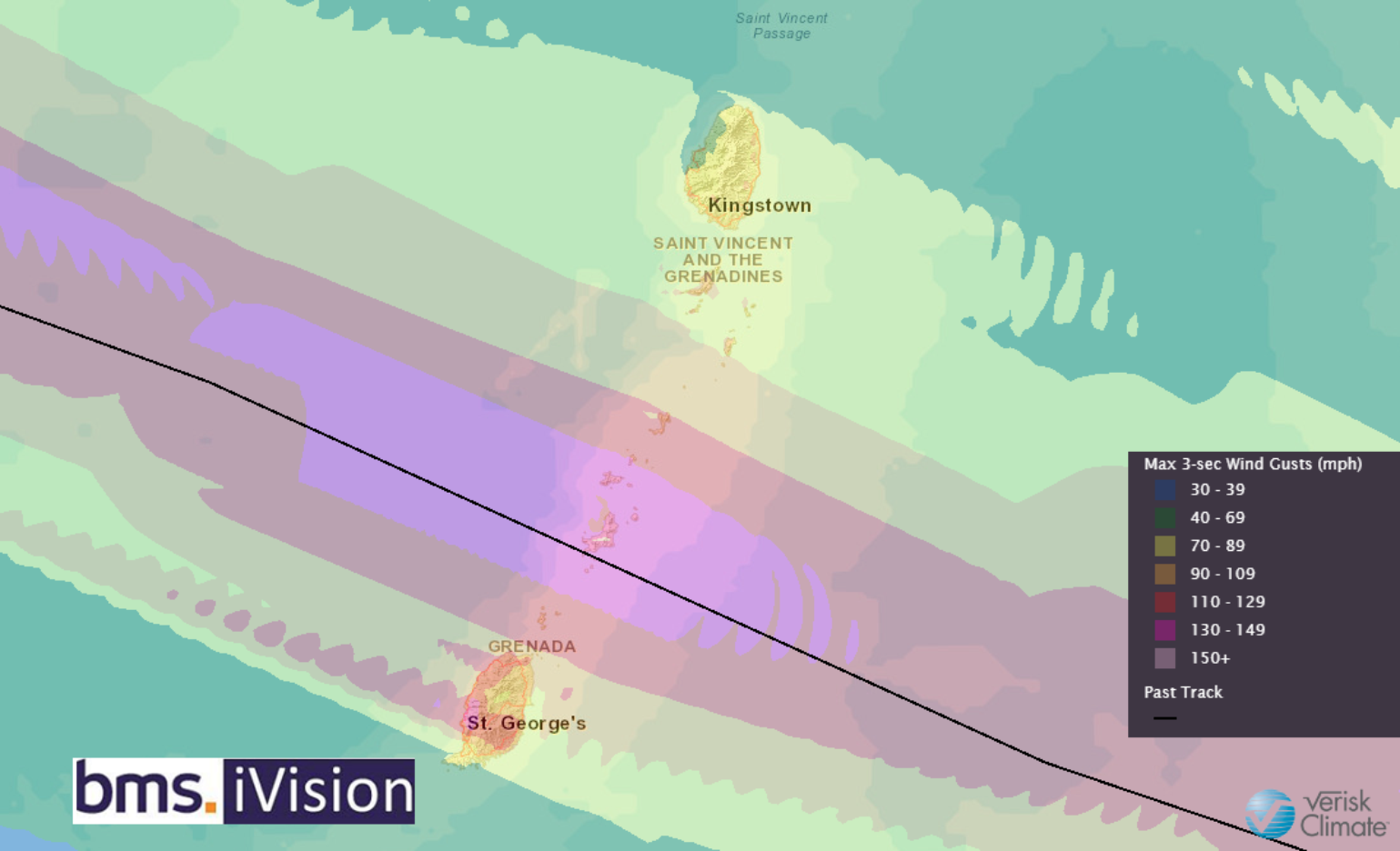
- The landfall of 150 mph near Grenada is the strongest hurricane by wind speed near Grenada or St. Vincent / Grenadines
- Beryl is the second Category 4 hurricane to track within 75 miles of Grenada (Ivan 2004 was the other)
- The second-strongest hurricane to make landfall anywhere in the windward islands. Maria, in 2017, had 165 mph winds in Dominica
As mentioned in our BMS Tropical Update yesterday, the small island of Carriacou, with a population of about 10,000 people across 13 square miles, took a direct hit from Beryl. We also mentioned that SpaceX delivered new satellites to help in earth observations. Still, they have also allowed the StarLink network to provide quicker access to communication after a disaster. As a result, the world is getting many photos and videos coming from Carriacou after Beryl’s battering. Most of the homes sustained roof damage, but thankfully, many of the structures' outer walls are still intact. The well constructed structures did fairly well, while the basic wood construction are completely destroyed. The trees were not so fortunate, and this is a major de-leafing event, as expected, with winds of this magnitude. Overall, insurance industry losses will be lower (low $100's of millions) because of the lucky track between the more populated islands of Grenada and St. Vincent, with these islands only seeing tropical storm force winds to low Category 1 winds. Still, the smaller Grenadines islands will have a long road to recovery, most likely taking years. The residents of these small islands like Carriacou need immediate help, as the tropical hurricane season is just beginning, and more trouble could be coming.

Beryl Forecast and U.S. Landfall
Next up for Beryl is a close call with Jamaica, which could be the strongest storm to potentially strike the island since Dean 2007. Typically, Jamaica (Kingston) gets brushed with tropical storm force winds every 4 years and hurricane force winds every 10 years, but major hurricanes are rare at a return period of about every 19 years.
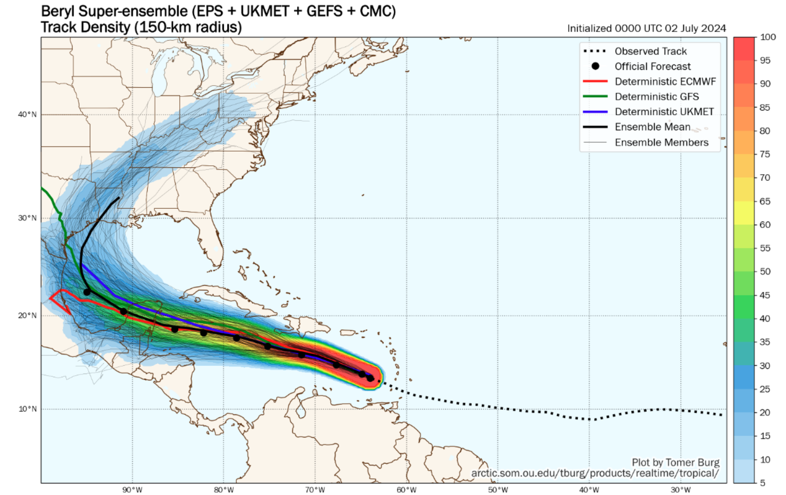
Now overnight, Beryl has a northwest jog to its track, which means the near-term movement and intensity need to be moved further north in the long-range track. One of the biggest changes in the last 24 hours of forecast watching is that all of Jamaica and Grand Cayman Island are in the National Hurricane Center track cone, and the wind field is bigger.
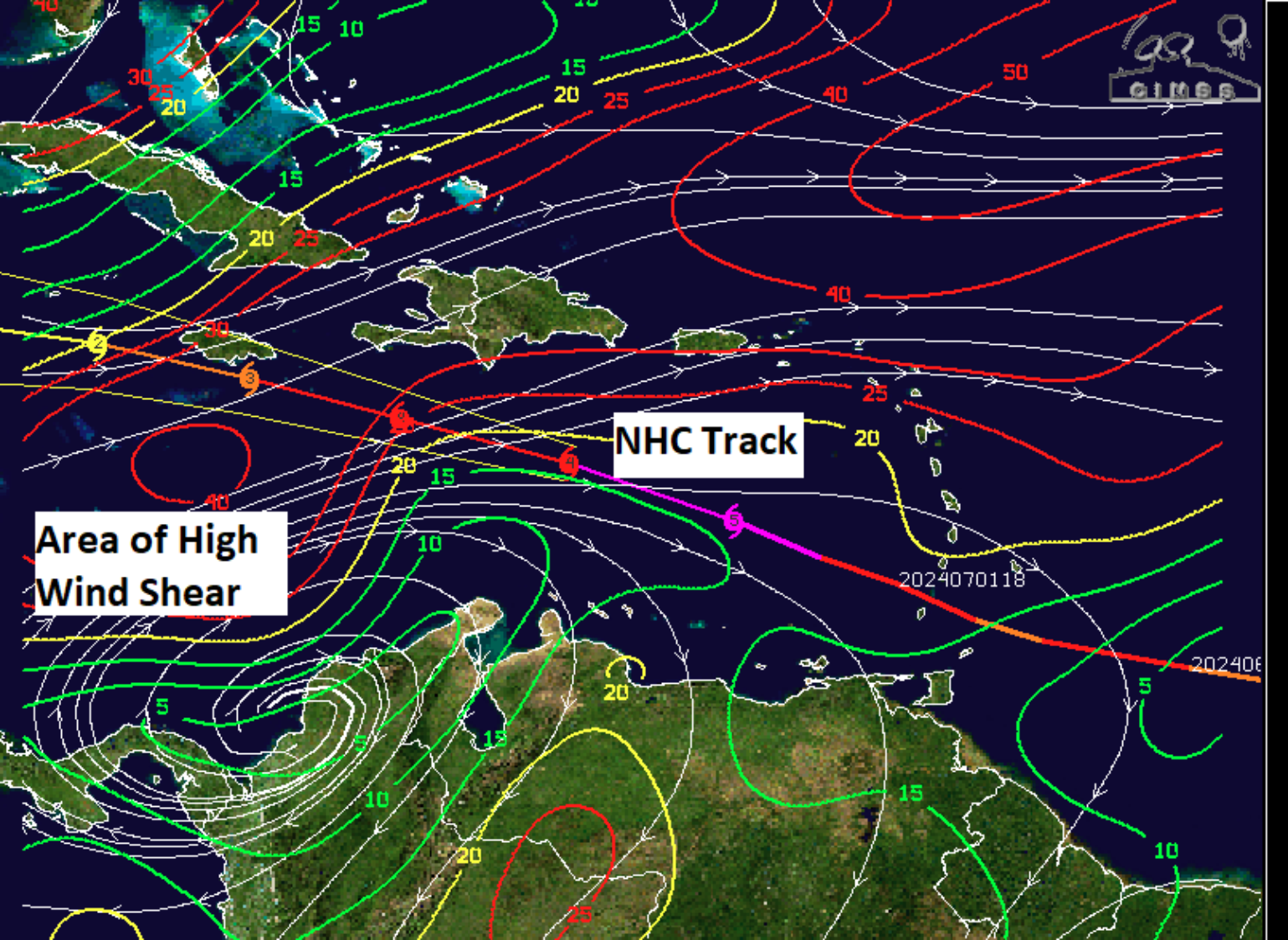
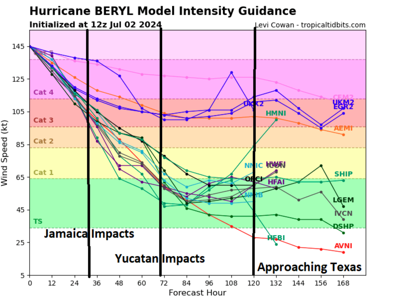
The good news is that the storm is expected to weaken, but the storm surge could be huge, and major hurricane conditions could still happen Wednesday into Thursday for this area. The NHC is not necessarily forecasting this, but Beryl could rapidly weaken as it approaches an area of 40 kts of wind shear just before Jamaica tomorrow.


As Beryl moves into the western Caribbean, there is uncertainty about its structure as it impacts the Yucatan Thursday night and Friday. More and more forecast model guidance starts to turn it north once it reemerges over the Bay of Campeche on Saturday. As the BMS Tropical update discussed yesterday, much of the future fluctuation and strength will depend on shear and land interaction over the next several days. The ensemble mean will be biased to storms that make it across the Yucatan and into the Bay of Campeche. The current steering flow is provided by a prominent ridge of high pressure over the southeast U.S. This ridge is expected to weaken and retreat to the east, replaced by a central U.S. trough, a reoccurring pattern the last several weeks. This is why some ensemble model members curl Beryl north in the western Gulf this weekend/early next week. There is still a lot of warm ocean water to keep Beryl going or strengthen it at times if the upper-level winds and moisture allow it to do so.

The other major change since yesterday is the trend to the north, with the probability jumping from 10% in Texas to 35% of an insurance industry impact for Texas and Louisiana. Impact probability is starting to show up with a 5% probability, and we expect this probability trend to continue upward. As a result, it is imperative the insurance industry keep an eye on the long-range ensemble forecasts and the Texas coastline. Although uncertainty is high, some guidance has Beryl as a tropical storm at this point, while some keep it as a hurricane. With this in mind, the western Gulf needs to be on alert for the latter part of the holiday weekend and early next week.
