The insurance industry continues to be on pins and needles even as the hype of an active Atlantic hurricane season slowly fades and the chances of overall activity in the Atlantic Basin likely being below normal. However, on the heels of the 30th anniversary of Hurricane Andrew, we all remember that it only takes one for a memorable season.
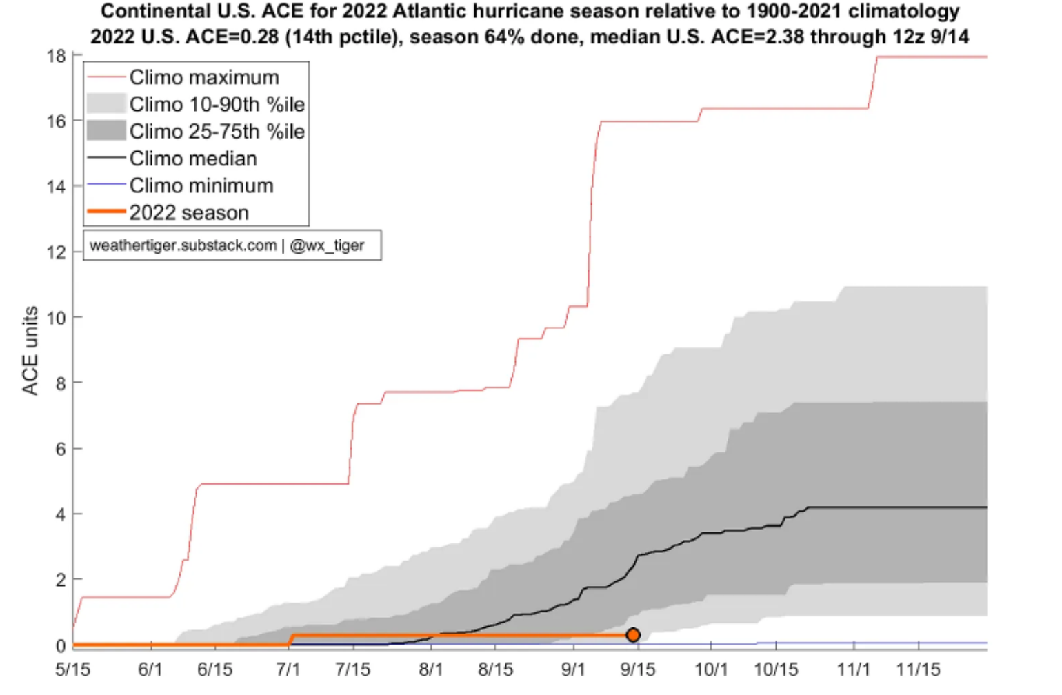
On that note, with every passing day, there seems to be a key hurricane landfall anniversary. Back on September 10th, was Hurricane Irma (2017), and on September 14th, was Hurricane Florence (2018). These anniversaries highlight that the Atlantic basin is at the climatological peak of U.S. Hurricane season for landfalls. As discussed in the last BMS Tropical Update, the insurance industry has typically experienced 79% of the total insured loss before September 15th since 1995. Another way of looking at the U.S. landfalling season would be the amount of U.S. Accumulated Cyclone Energy that occurs over the Continental U.S. In a plot that Dr. Ryan Truchelut shared on his substack post, it showed that overall, 64% of the season is done, the median U.S. ACE Index as of 9/14 is 2.38. This year’s impacts only accumulated 0.28, which was from named storm Collin that formed along the South Carolina coastline around July 2nd.
Although we are now past the period when most of the U.S. landfalls and insured loss often occurs, that does not mean the U.S. is out of the woods quite yet. This is why many in the insurance industry have their eyes on recently formed Tropical Storm Fiona.
Tropical Storm Fiona is the sixth named storm of the 2022 Atlantic hurricane season. In a typical year, the sixth named storm often forms around August 29th, and the 9th named storm forms around September 16th. Of the 17 areas of investigations (invests) that the National Hurricane Center has been watching this season only 35% have developed into a named storm, which is the lowest percentage since 2010. Generally, the basin is much more active and climatologically this is the peak of the season. It is unusual for Fiona is the only game in town. This goes to show how hostile the overall conditions are in the Atlantic basin this season that will be impacting Fiona over the next few days.
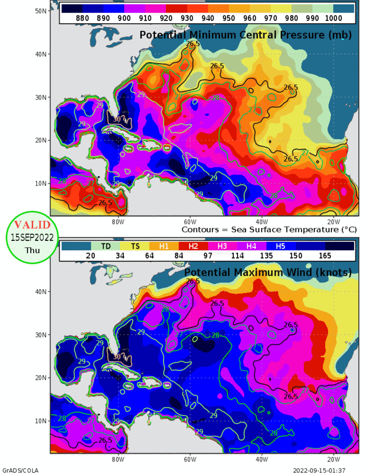
Much like the other Atlantic systems that have tried to develop this season, Fiona is fighting strong wind shear and drier air at mid-levels of the atmosphere. The strong wind shear keeps the strongest convection to the East of the low-level center that is often exposed to the west side of the convection. This wind shear and nearby dry air should limit any significant intensification for Fiona for the next several days. Fiona also shows the general myth that all that is needed for named storm formation to occur is warm sea surface temperatures when in reality, you need the perfect conditions to all come together. Under an ideal environment, much of the sea surface temperatures across the Atlantic basin would support a Category 5 hurricane. Still, this will not be the case at this time because the conditions are not perfect.
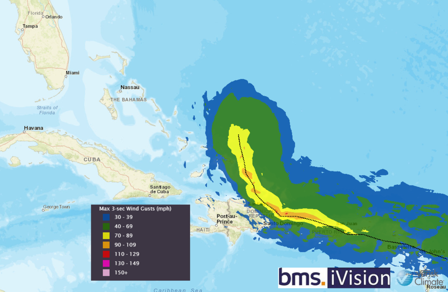
The overall future intensity of Fiona will depend on track. Currently, Fiona was tracking across the northern Leeward Islands by Friday night, near the Virgin Islands and Puerto Rico this weekend, and near Hispaniola early next week. Given this expected near-term track with less uncertainty, Fiona is expected to produce total rainfall accumulations of 3 to 7 inches with possible higher amounts across the northern Leeward Islands, the British and U.S. Virgin Islands, Puerto Rico, and eastern Hispaniola, depending on the forward speed and areas of intense tropical convection. This amount of rain will produce flash and urban flooding, along with isolated mudslides in higher terrain areas.
Fiona Forecast Track Uncertainty
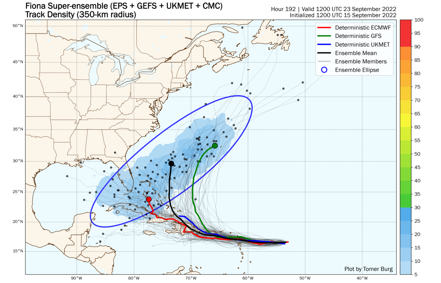
With so much uncertainty in the forecast, the best way to understand the possible solution is via the forecast models that produce ensembles. Each of these ensembles is a different forecast based on the overall uncertainty that goes into the initial start of the forecast, which in the end, results in a different forecast. Tomer Burg, an Atmospheric Science Ph.D. student at the University of Oklahoma, has compiled a super ensemble of track density of all the ensemble models together. This offers a realistic depiction of the uncertainty with Fiona's track into next week, as shown below. At this point, it appears that a track just east of the Bahamas is favored, but not guaranteed. As an experienced forecast would tell you, anytime you have a weak sheared tropical cyclone like Fiona that may interact with the Caribbean islands, a change in track or total disruption of the circulation may occur. When you combine this with the overall uncertainty in the medium – long-range steering pattern, a lot can still happen with the ensembles’ forecast. Each of the forecast ensembles provides a different scenario of what could happen. The weaker scenarios appear to keep Fiona weak and sheared and have the track staying on a westward trajectory. This builds in a lot of uncertainty at longer forecast periods for U.S. impacts. The stronger Fiona is over the next few days these ensembles provide a scenario that turn Fiona to the north before Hispaniola or the Bahamas. Another factor to consider is how a mountainous island such as Hispaniola can impact a storm. Often these islands only have short-term impacts on the overall structure of the storm. About a dozen and a half named storms have directly interacted with Hispaniola since 1995. Nearly two-thirds (6 out of 17) of them were strong and impactful to the U.S. after.
One thing to note in the long-range forecast is how it can be tied to Typhoon Merbok in the Western Pacific. In previous year’s tropical updates there have been references to the general rule that a recurving typhoon into the mid-latitudes can have a major influence on named storm tracks. When this occurs, it alters the jet stream, which in turn, alters the weather pattern over North America. Often this results in a trough of low pressure moving into the East Coast of the U.S. six to ten days later. After Typhoon Merbok recurves in the next day, providing quite a punch to coastal communities in western Alaska, a trough of low pressure digs into the Western U.S., and a ridge of high pressure builds in the Eastern U.S. for the start of next week. This is a flip of the current North American weather pattern that has seen record heat and fires out West and fall-like conditions along the East Coast. Yet, in the long-range, later next week, when Fiona is past Hispaniola maybe near the southern Bahamas, we need to see if a trough of low pressure can develop back along the East Coast and kick Fiona back out to sea. As the ensemble plot indicates above, a lot can still happen in the long-range forecast. Given Typhoon Merbok, I would expect much higher overall uncertainty in the forecast as the downstream weather pattern amplification it causes results in a lot of forecast run to run variability.
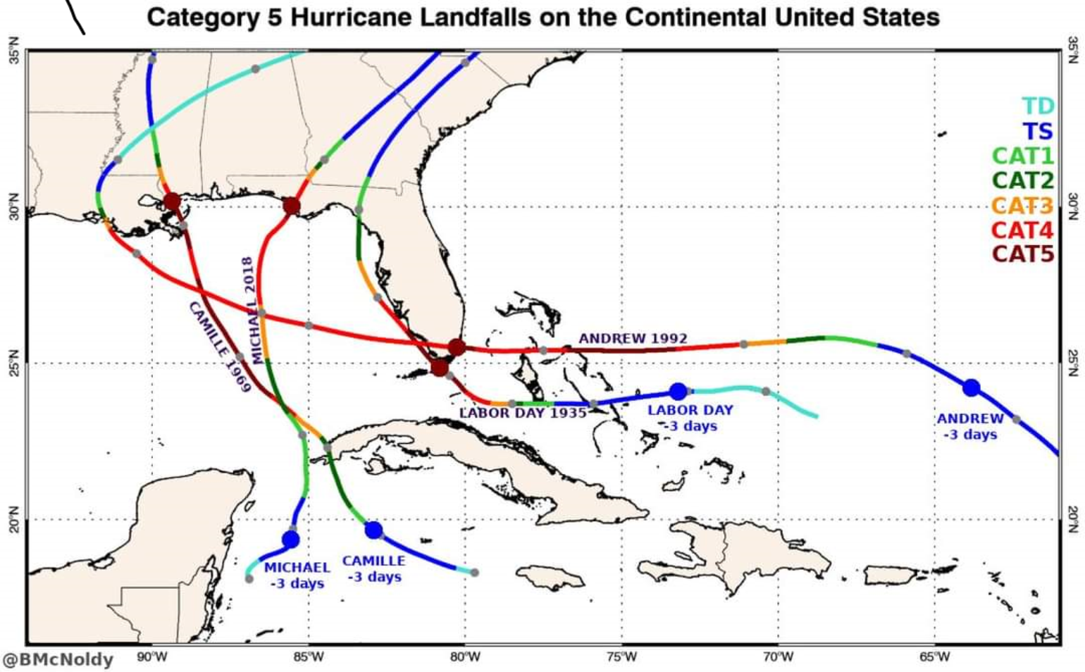
As we previously discussed hurricane anniversaries, Hurricane Jeanne 2004 comes to mind, which occurred on September 26th and took a very similar track as Fiona is forecasted. However, Jeanne did a loop East of the Bahamas before striking the East coast of Florida. Interestingly enough, it was the last major hurricane to make landfall along the East Coast of the United States. Another reminder to take note of is that all four Category 5 hurricanes at U.S. landfall were from storms that were not even hurricanes just three days before landfall. Accurate forecasts of rapid intensification remain extremely difficult to make. The good news is that there is very little support for this type of forecast.
What is known is that Fiona will have weekend impacts on the northern Caribbean Island. The forecast continues to be murky past Tuesday next week. And, more data from how the pattern unfolds from recurving Merbok and how Fiona track and intensity verifies with hurricane hunter data will help in the coming days.
Right now, messy forecasts like this will make one humble. Fiona remains worth watching for the Continental U.S. for seven to ten days for how the model will pick up on the a potential trough of low pressure later next week and if Fiona will track out to sea or not.
Side Note: Super Typhoon Nanmadol is predicted to strike Japan with 125 mph category 3 winds in the next 48 hours. This is looking like a devasting blow for Japan as Nanmodol tracks are northwest along the entire length of Japan's mainland. This will likely be a pretty big news event for the worldwide insurance industry next week.