Far Away Impacts
With Erin safely recurving between the U.S. East Coast and Bermuda, there will be limited to no major insurance impacts. The biggest impact will occur on the Outer Banks of NC with winds expected to be 50-60 kt (60-70 mph) as Erin passes by some 230 miles (383 km) to the east. Below is our BMS Verisk Respond wind gust wind swath, which helps carriers better understand wind impacts at a location and portfolio level.
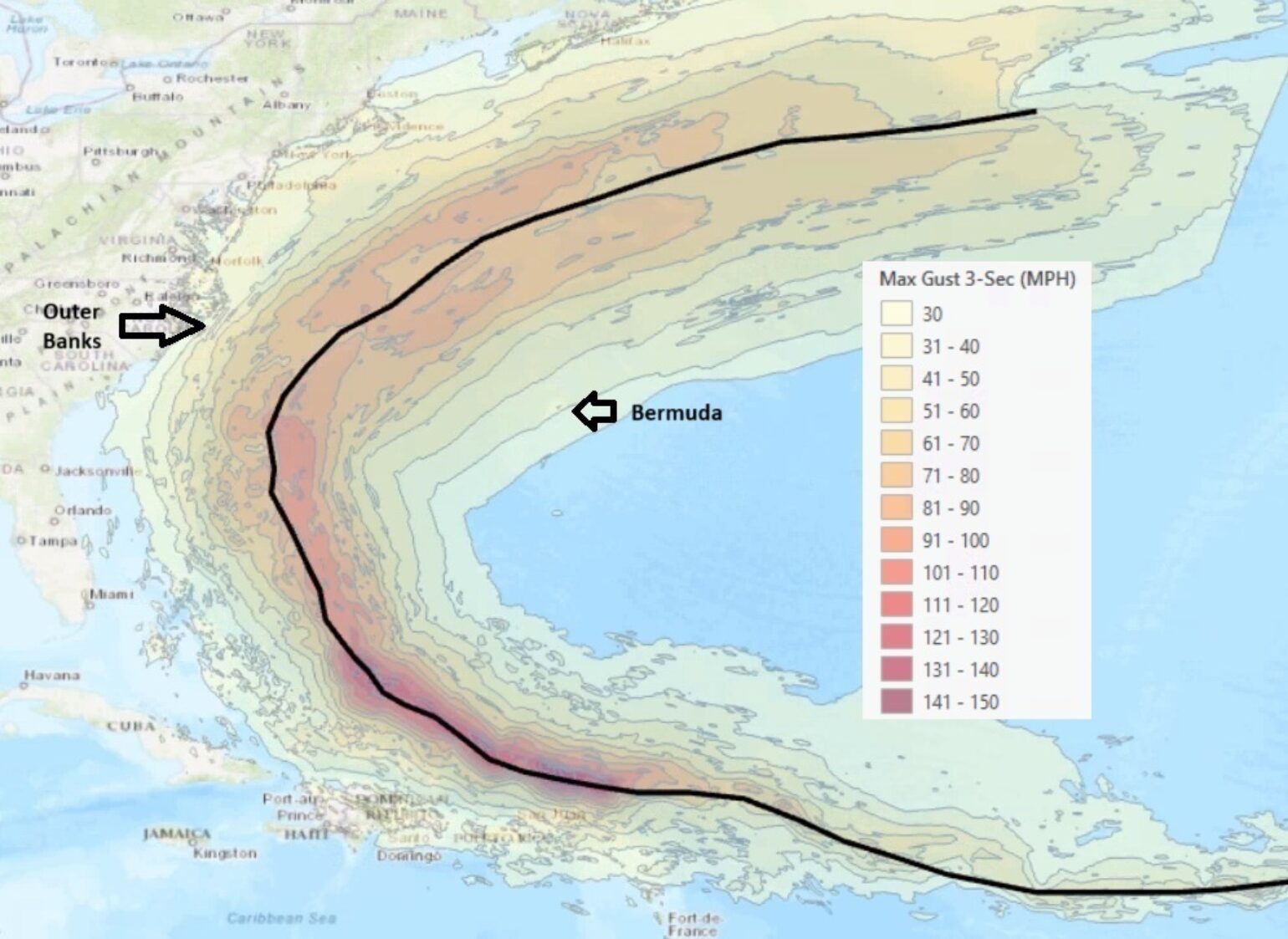
While the core of most destructive winds will stay offshore, these gusts could get close enough to cause some damage to homes that have not been fortified. Still, a bigger problem may be the prolonged duration of the persistent northeast wind gust, which is why we examine gust duration as a key variable for insurance carriers, as shown in the plot below from our BMS Verisk Respond wind duration product.
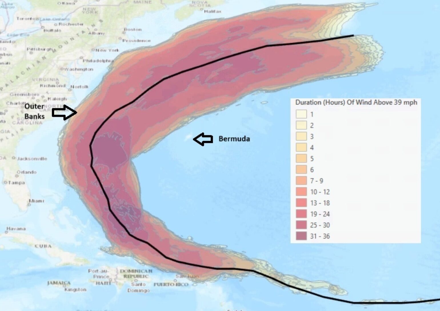
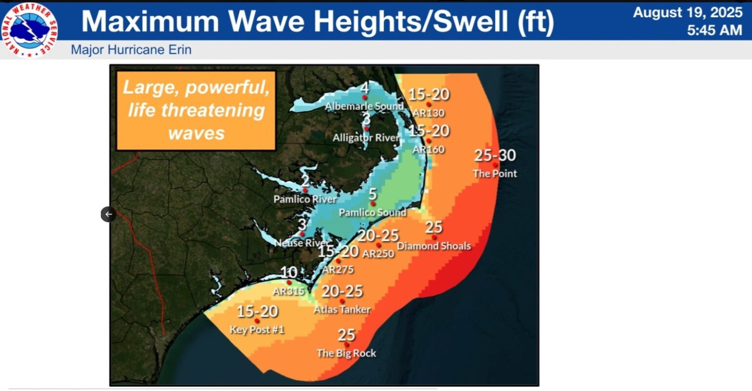
It is this persistent northeast flow that will cause some significant coastal impacts. Extensive beach erosion will likely occur due to strong long-period waves, as high as 15 to 20 feet in the surf zone. These large waves will also create coastal flooding and ocean overwash, especially around high tide (6 am – 7 am and again 6 pm to 7 pm), Wednesday into Thursday. Portions of Highway 12 on the Outer Banks may be impassible for days. Don’t be surprised to see the lower level of structures along the Outer Banks flooded. One should not be surprised if the abandoned stilt homes in Rodanthe, NC, are taken out by the powerful surf. Overall, this coastal flooding should result in limited losses to the insurance industry. The rest of the East Coast will also see beach erosion, tidal flooding, and rip currents through the week.
As the insurance industry experienced with hurricane Helene last year, bypassing the central coastline of west Florida, Erin will be yet another reminder that just because a hurricane isn’t impacting a landmass, it doesn’t mean it can’t influence other types of weather that could result in insurance loss. It is not just faraway high surf and storm surge that can cause damage. As mentioned in the Friday Tropical update, one of the possible Gray Swan events could result in an exclusionary effect of bypassing Erin on the Canadian Maritimes and the potential increase in wildfire risk such a situation might bring. Nearly all of the island of Newfoundland is under extreme fire risk warning, with some parts of the provincial capital of St. John's now under evacuation from a nearby fire. Of course, this enhanced fire risk is all hypothetical at this point. If this hypothetical situation becomes more of a threat, we will mention this. Otherwise, for the best forecast info for Erin, it is advised to follow the National Hurricane Center (NHC) forecast, which now covers Erin through the start of next week.
Watching the other areas for tropical trouble
With all eyes on Erin over the next few days, the insurance industry is likely to be focused on two other tropical waves the NHC is watching in its 7-day forecast outlook. The next two tropical waves are located over the central Atlantic and off the coast of West Africa. Like Erin, these tropical waves will be slow to get organized due to dry air and marginal upper atmospheric conditions. However, as these tropical waves move further west, they will be in a much better environment for organization. Currently, the NHC has a 60% chance of development for the first tropical wave and 30% for the second tropical wave over the next 7 days. One reason for concern about these tropical waves is that the insurance industry has just witnessed the potential of tropical disturbances tracking over warm water, as evidenced by Erin's remarkable rapid intensification once it encountered the right sea surface and atmospheric conditions. Erin will go down as peaking as a Category 5 hurricane. Making Erin the 43rd storm to reach Category 5 status in the Atlantic Basin since records began in 1851. Erin is now also the first Category 5 hurricane in the Atlantic since Hurricane Dean in 2007. It also had the 2nd-lowest pressure below 20°N this early in the calendar year (at 915 mb), only behind hurricane Allen 1980 (at 911 mb). Erin was very angry, and if Erin were 150 miles further south, the insurance industry would have been dealing with a significant loss event for some of the northern Caribbean islands.
Clustering
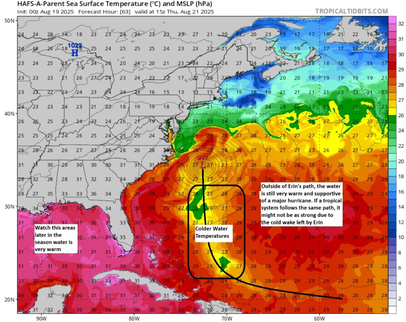
The insurance industry is all too familiar with clustering, and all too often storm clusters take similar paths, but not the same path, as we saw with Helene and Milton in the Eastern part of the Gulf last year. Unfortunately, these subsequent tropical waves are already further south than what Erin was tracking off the Coast of Africa. This means that the possible tropical development would have a greater impact on the northern Caribbean islands. This also means the cold wake of Erin won’t hamper tropical development if a tropical system tracks further south than Erin did. A cold wake is a wake of cold water that is the result of wind and waves bringing up colder water from depth. This will limit fuel for tropical convection if the tropical waves take the same general track. Below is the forecasted Sea Surface Temperature (SST) change as Erin tracks north.
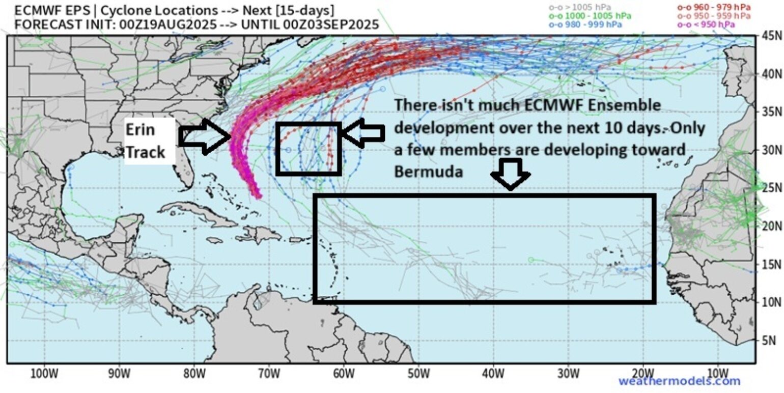
As with Erin, consolidation of tropical features will be slow to occur with these tropical waves, and I wouldn't expect a tropical storm for several days at least. ECMWF ensemble guidance shown below does not have a high probability of development with the tropical wave current in the middle of the Atlantic. It shows the wave coming through or north of the Caribbean islands on Friday, possibly as a tropical depression. Overall, the long-range weather pattern at this time suggests less of a Bermuda high, partially thanks to a slower recurve of Erin, so at this time, this tropical wave will also likely recurve East of the United States. The second tropical wave off the coast of Africa appears to be at a lower latitude, which will present near-term challenges in development over the next 7 days.
The East Coast hurricane drought continues as we approach the peak of the Atlantic Hurricane Season that starts tomorrow (August 20th). While it is worth keeping an eye on things, as right now hurricane clustering can provide some hints on what might happen in the future, at this time, it is still far too early to weigh in on what might happen the week of August 25th. Hopefully, the basin shuts down until later in September.
