After nine days and well over 10,000 words written in these BMS Tropical Updates, it appears that the end is in sight, but not before the biggest impacts from Dorian are felt by the insurance industry. Interestingly, though, it seems that interest on social media and other mainstream media regarding some of the impacts of Dorian may have waned because the hurricane is not as powerful as it once was and not threatening the larger population of Florida. This seems to be the classic psychological burnout of media hype and letdown, while actually downplaying the impact of the real event for the U.S.
Dorian is still a back up to a Category 3 hurricane that could very well still make landfall along the North Carolina coastline. If it stays at Category 3 strength it could be the first Category 3 hurricane to make landfall in North Carolina since Fran in 1996, which coincidentally made landfall on Cape Fear, North Carolina 23 years ago on September 6th.
WindImpacts
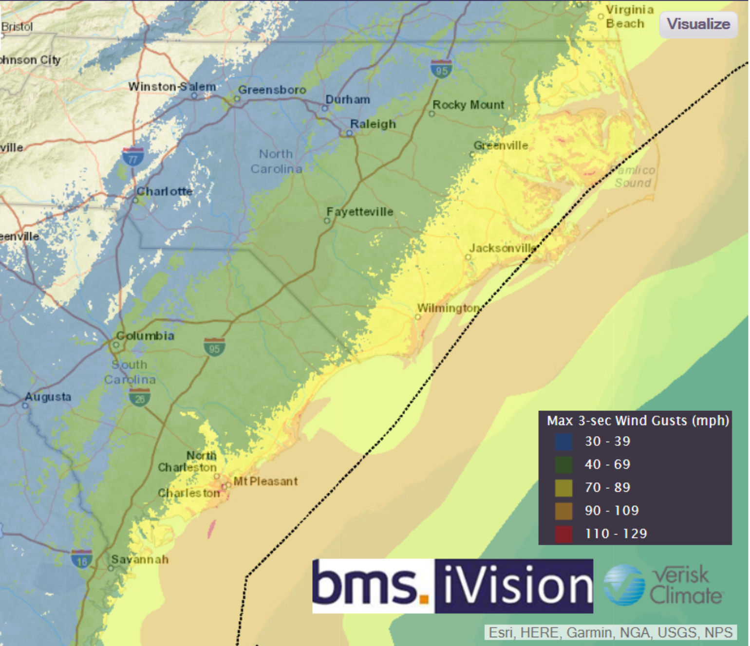
Dorian is currently located just 50 miles east-southeast of Charleston, South Carolina, and is moving to the north-northeast at only eight mph. The effects of the storm are being felt along the South and North Carolina coastlines. The strongest wind gust I have observed as of 5:00 A.M., CDT, was 68 mph at Charleston Airport. Tropical storm-force winds have been observed along the South Carolina coastline, resulting in about 240,000 reported power outages with that number likely to grow over the next 24 hours. Dorian is still expected to track right along the coastline and could make landfall near Bald Head Island or Cape Lookout, North Carolina. Although the strongest winds are on the right side of the storm, and will remain offshore, there is little chance that hurricane conditions will not be experienced along the coast given how close Dorian should track to the coastline. The worst impacts are likely to occur on the Outer Banks of North Carolina.
Tornado Impacts
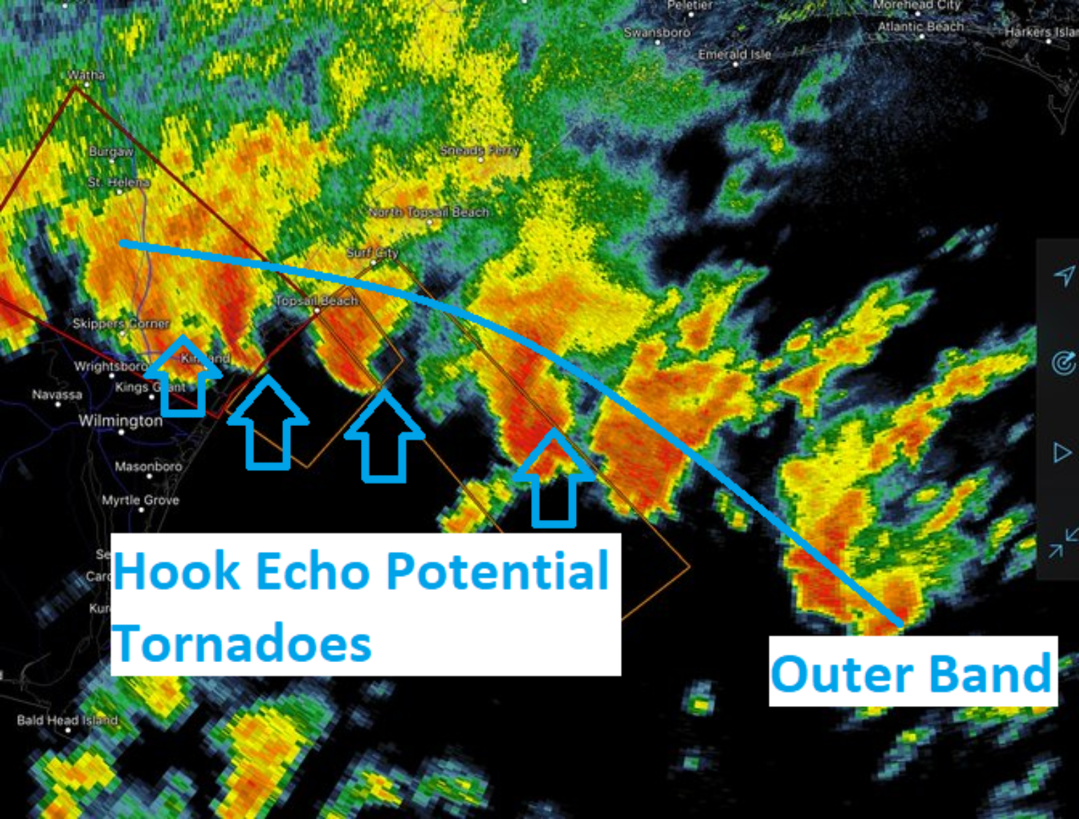
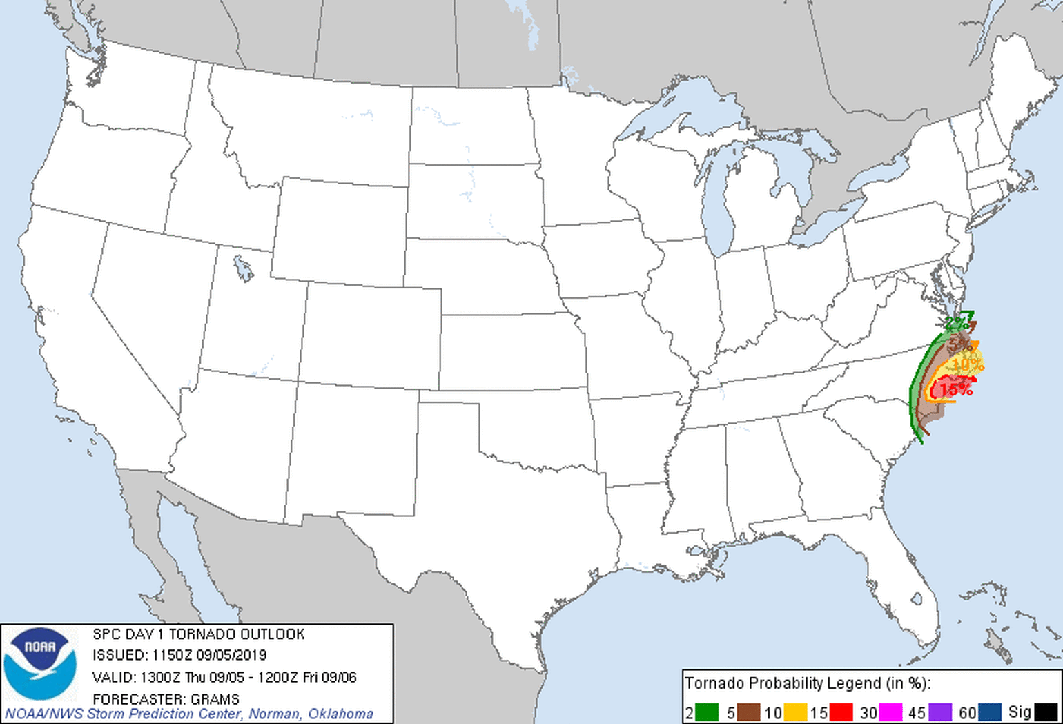
Accompanying the high wind gusts embedded in some of the outer band thunderstorms could be tornadoes. Although often weak and very localized, these tornadic winds can still cause unexpected damage compared to normal tropical-storm-force winds only. Tornadoes often form in a hurricane’s northeast quadrant and today this quadrant will be over North Carolina.
Wedge waterspout coming ashore in Emrald Isle, NC #ncwx pic.twitter.com/brQIvKCT6U
— Peter Forister (@forecaster25) September 5, 2019
**TORNADO THREAT CONTINUES** Another tornado captured on camera this morning near North Myrtle Beach, SC. Watch how fast this storm races across the area, some of these storms were moving up to 50 mph! #scwx pic.twitter.com/4RV6epevXq
— WeatherNation (@WeatherNation) September 5, 2019
Storm Surge
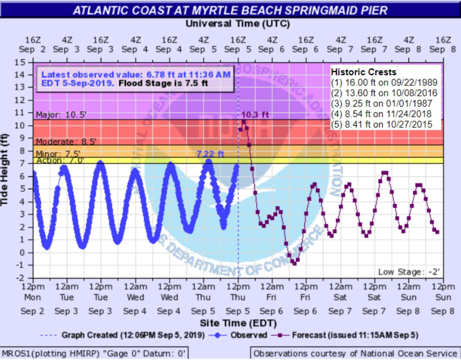
Although the moon phase has now moved away from the new super moon phase on August 30, the tidal cycles are still important in relation to the height of water inundation along the coastline. Last night, cities like Jacksonville and Charleston may have caught a break when the highest storm surge was at low tide. However, the forecast data for Myrtle Beach, SC does suggest that water could reach a height of 10.3 feet, which would put it at the third-highest tide in history for the city. Other coastal cities such as Wilmington, NC may also feel similar effects as strong onshore winds push water up along the coast as Dorian slowly tracks along the coastline. The storm surge will move into the Outer Banks tomorrow, where some of the islands are historically susceptible to water overtaking them and even creating new inlets, cutting off the islands from the only road access. For an up-to-date view of detailed weather impacts please check out the NHC storm surge inundation forecast.
Rainfall
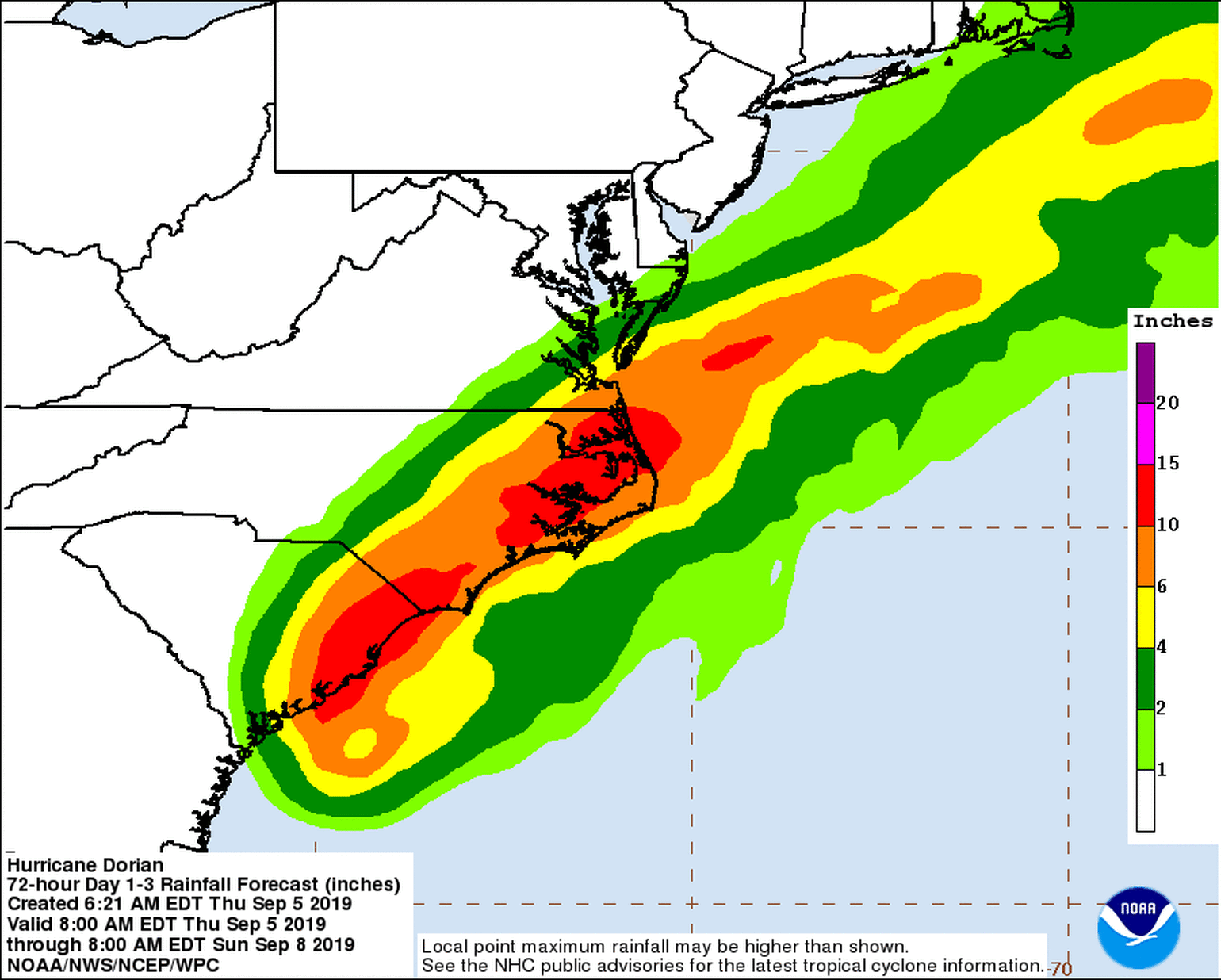
As expected with a slow-moving major hurricane, rainfall and flooding will also become an issue for coastal areas. Forecasts call for in excess of 10-15 inches to fall along the coastline. Combined with storm surge, this will likely create areas of significant flooding or flash-flooding.
Analogs Impacts
Although I mentioned tomorrow is the twenty-third anniversary of major Hurricane Fran making landfall in North Carolina, I don’t think Fran is a good analog for Dorian. Alternatively, Arthur in 2014 continues to be a good analog event, even if, as noted in an earlier post, it remains the only Category 2 hurricane to make U.S. landfall and not result in an insured loss, according to Property Claim Services (this is unlikely to be case with Dorian). In other earlier blog posts I mentioned the North Carolina impacts from Floyd in 1999 and Matthew in 2016 make a good analog package. Matthew resulted in $1.2B of insured loss to the same areas, and today Floyd would result in about $2.6B of insured loss, which seem to be a safe range of expected losses at this time for Dorian.
Other tropical troubles
We are a few days removed from the peak of hurricane season, but the Atlantic basin is still very active with several areas of tropical trouble. The insurance industry will need to focus its attention on impacts from Dorian as there is nothing that is a threat to the industry over the next two weeks. But, the end of this month could provide some more excitement.

