Hate Being Wrong
Meteorologists hate being wrong, but with the magnitude of potential disaster that is ahead for the insurance industry this week, I hope I am. I have been working in the insurance industry for the relatively short period of 16 years, but I have also spent a lot of time researching the historical impact of past hurricanes on today’s exposure. I am concerned that what may occur later this week will likely be talked about for decades to come.
Track and Intensity Details
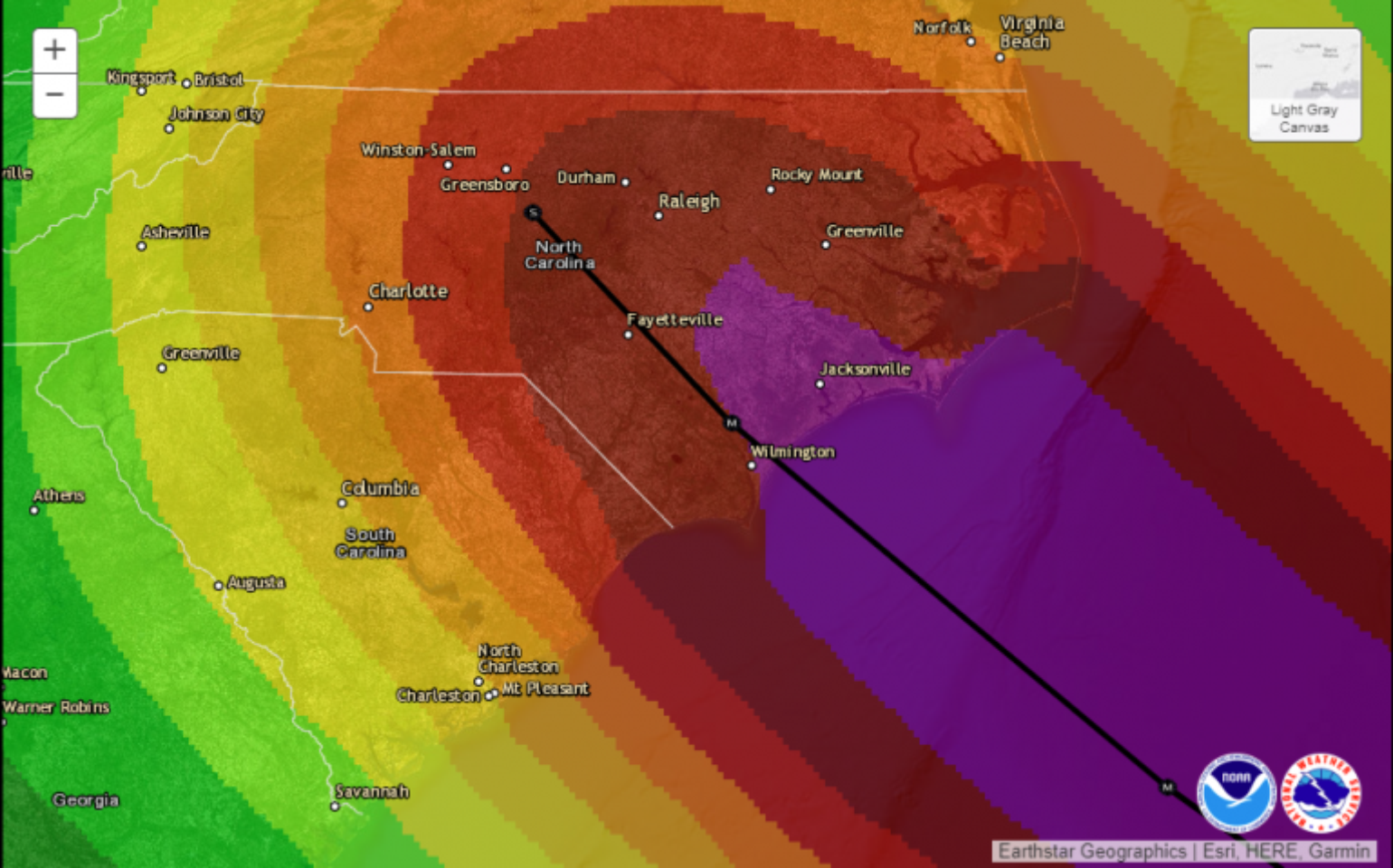
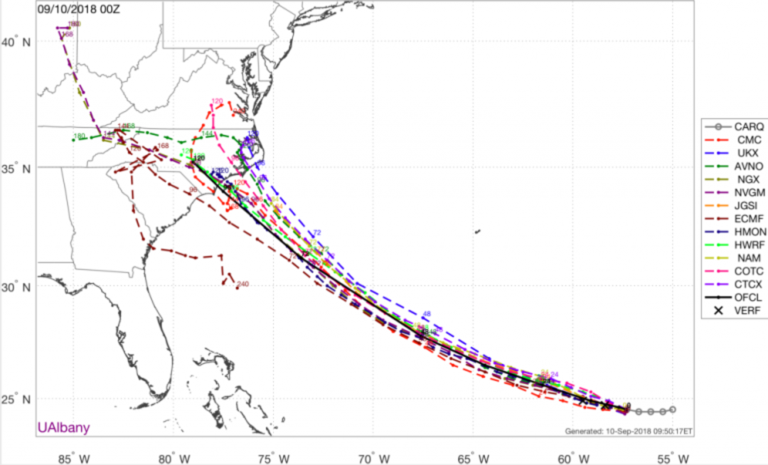
We are now past the point of having to focus on which model is performing best, as the majority of the model guidance is in agreement. It is now time to focus on the fact that Florence is going to make landfall, but the main forecast question now is what will Florence do as it nears the coastline? A blocking high pressure ridge is expected to slow Florence down or potentially even stall the storm. A stalled storm will bring a prolonged period of additional heavy rain (think Hurricane Harvey last year).
Although there will likely be some track shift on the exact location of the strongest winds at landfall, which is a very important detail for estimating insured losses, this detail won’t be known for another 48 hours or more. The overall intensity of the storm will likely influence the final track, and the intensity forecast is just now starting to play out. The loss potential is much smaller if the strongest winds are focused south of Myrtle Beach over the Tom Yawkee Wildlife area than if the strongest winds occurred over Myrtle Beach, SC, Charleston, SC or Wilmington, NC.
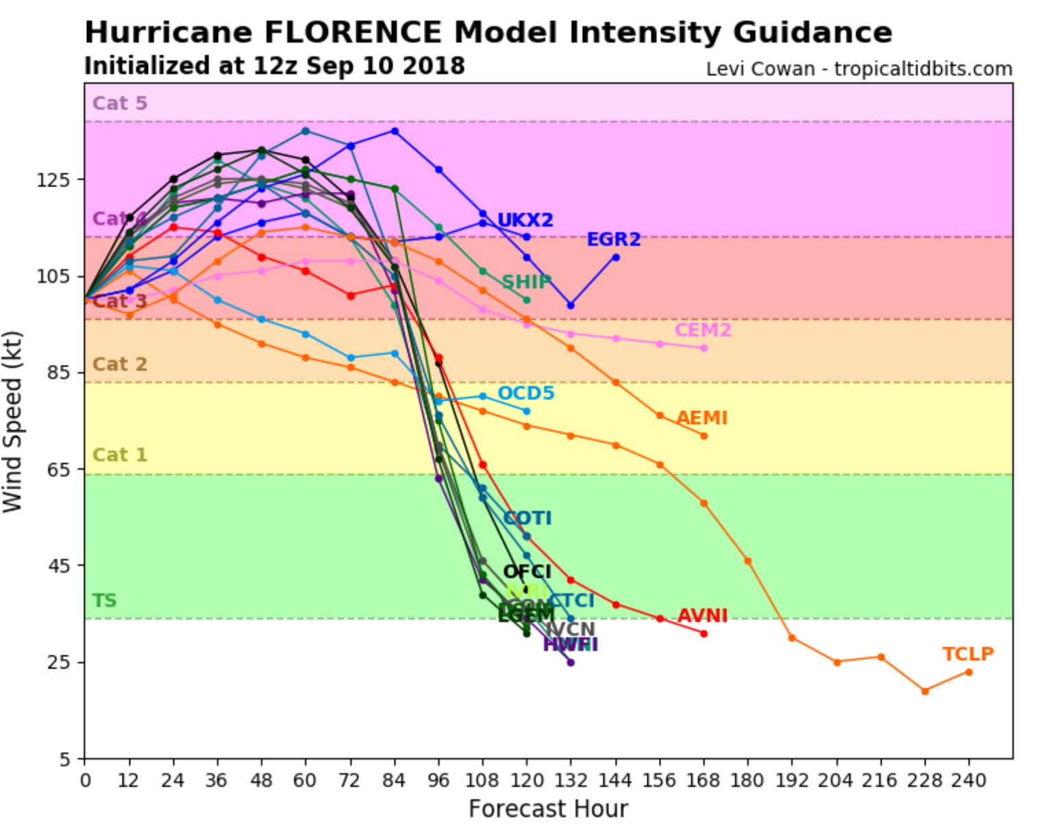
After weakening from its Category 4 start last week, Florence is now undergoing rapid intensification, with many of the intensity forecasts showing a range between Category 3 to Category 5 over the next four-day forecast period prior to a potential landfall.
This is all driven by an environment of low wind shear and significant upper-level outflow, which are perfect conditions for building intensity in a named storm. If you add in the fact that Florence will be moving over the very warm waters of the Gulf Stream, which are already as much as six degrees warmer than average, there should be no reason why Florence wouldn’t maintain major hurricane status until landfall. A Category 5 hurricane is becoming likely at some point in the next few days. The only formalities will be internal eyewall replacement that will allow for small fluctuations in strength, but it's a double-edged sword: a slightly lower wind speed will probably mean a larger sized storm.
Another thing to watch before landfall is an increase in wind shear. Some models are showing this, which would help weaken Florence slightly before its potential landfall. This is something that will be well known in the next day or two, with Florence still likely to be a large damaging hurricane at landfall.
Potential Impacts
Storm Surge
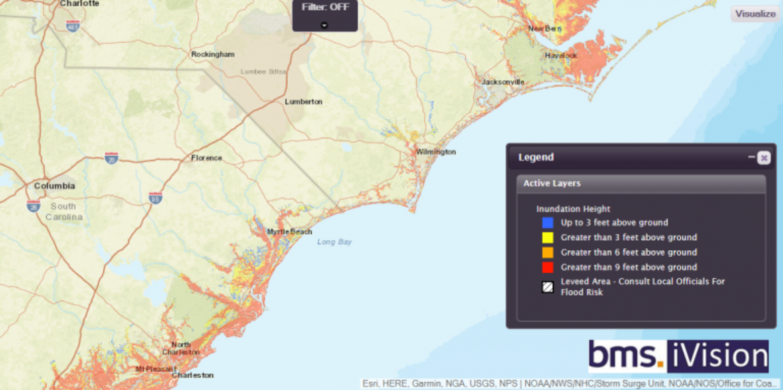
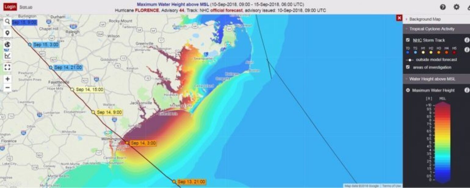
Should some of the intensity forecasts become verified, a Category 4 storm impacting the coastline of the Carolinas would be dangerous and problematic. Although the NHC hasn’t yet begun to issue official surge forecasts, overall the Carolinas’ coastline is particularly vulnerable because of low lying barrier islands, inland waterways and bays that can amplify surge. Because there is uncertainty in the track, the best tool to use right now is the NHC’s Maximum Of Maximum (MOM) storm surge layer, which is an attempt to quantify the potential impacts of storms of different strengths at different angles. This is done by running an ensemble of simulated Category 4 landfall scenarios for a region to get an idea of the maximum storm surge that can occur over various sections of the coastline. It should be noted that this is not a Florence forecast. I expect the NHC to begin issuing better storm surge guidance on Florence by tomorrow.
Waves
The force of water can’t be underestimated and, depending on track, waves as high as 15 feet are expected to crash along the coastline and add to the storm surge impact.
Rainfall and Flooding
Unlike Harvey (in flat terrain), Florence is coming onshore to hilly and mountainous terrain. This will magnify rainfall from orographic lift and runoff will channel into devastating flash/riverine flooding as well as liquefy mountain slopes. The amount of rain will surely impact infrastructure. We have seen time and time again from past flooding events that 10-15 inches of rain over two days is beyond the design capacity of most storm water infrastructure, which creates even more problems beyond flooding on roadways, rivers, creeks and streams.
Based on the government’s quantitative rainfall forecast product, the maximum amount of rainfall that is forecast is more than 15 inches! What makes this even worse is that more rain than usual has fallen during the last 30 days over most of the area where Florence's heaviest rains are forecast to fall.
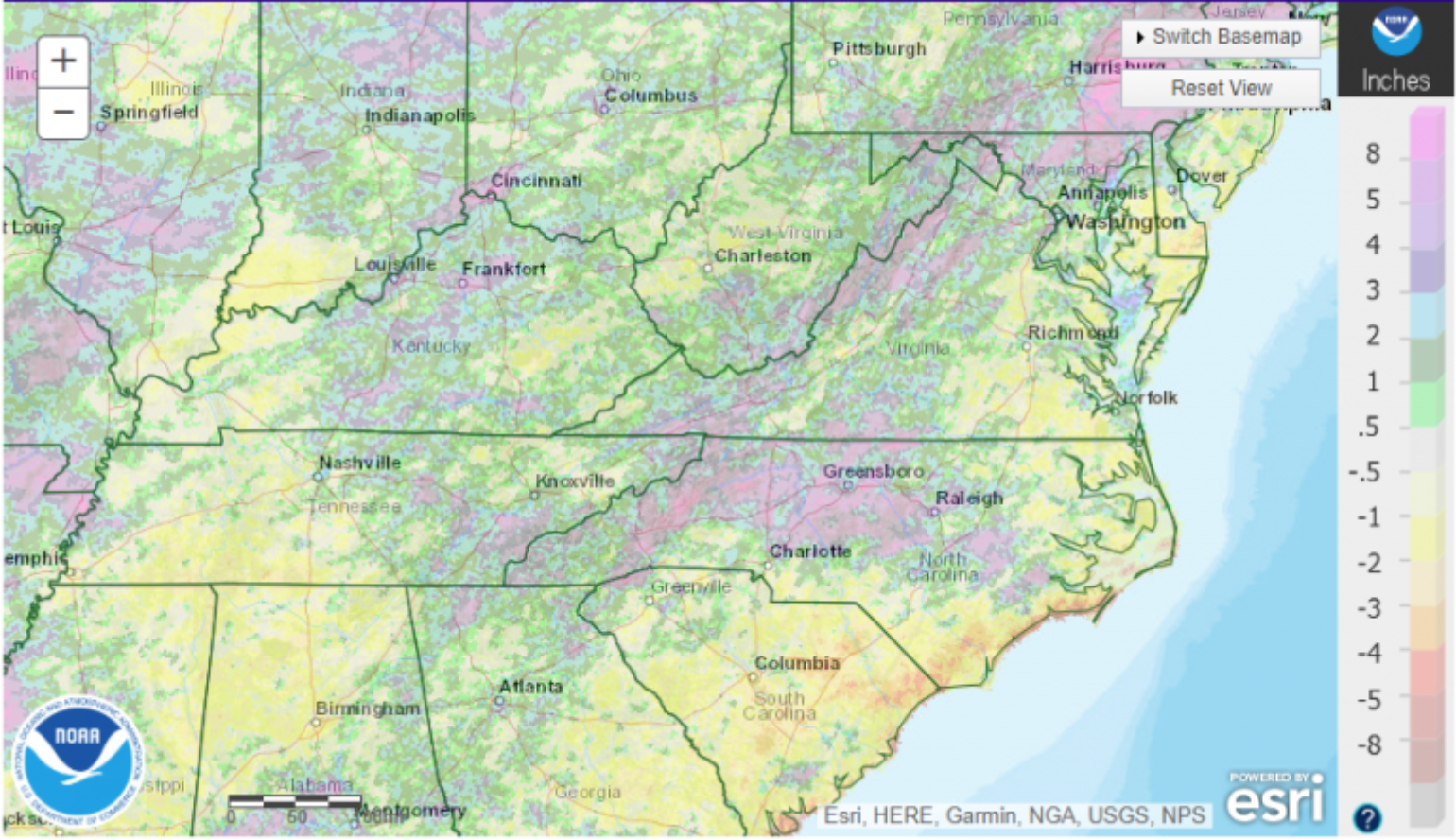
With already wetter than normal conditions, the excessive rainfall from Hurricane Florence will...
• Run off more quickly than usual into rivers that are already higher than usual.
• Weaken the soil which could increase tree fall and increase insured loss.
Keep in mind that the models do not do a great job with forecasting rainfall over more complex terrain. In fact, total rainfall forecasts are difficult, period. As an example, days before Hurricane Harvey’s torrential rain began in Houston, the maximum amount forecasted for the region was 29 inches. However, the heaviest actual amount was 60.58 inches!
I expect many rainfall and river level records for the area to be broken, including many set from 1973’s Hurricane Agnes, which caused record flooding in the Mid-Atlantic region with less than 15 inches of rain over Virginia and West Virginia. Again, let’s hope that the government meteorologists are wrong with the forecasted rainfall amount of 15 inches from Florence.

Flood Maps
A quick reference for potential flooding might be the FM Global Flood mapping tool, which allows users to understand areas that are prone to flooding in great detail. Another resource might be the real-time flood network for NC.
Power Outages
Given the potential amount of rainfall and hurricane-force winds reaching areas well inland, the insurance industry should expect high amounts of tree fall that will produce power outages. In the past, the Guikema Research Group at the University of Michigan has produced power outage maps. I contacted them and they will be running their model today, but www.poweroutage.us will be the source to watch as Florence makes landfall.
Building Codes Matter
The importance of strong, well-enforced building codes was clearly demonstrated with the hurricanes of 2017. The Insurance Institute for Business and Home Safety (IBHS) provides technical guidance to inform and improve model building codes, advocates for timely adoption of national model building codes and standards, and encourages uniform enforcement of these codes. In its “Rating the States” report, South Carolina scored among the highest states in the country and North Carolina was just slightly lower. However, as we saw with Hurricane Irma and Florida, (one of the highest scored states in the country), building codes are important to limit damage but are a minimum requirement. The expected winds from Florence will likely be at or above the codes that are enforced.
Insured Loss
The catastrophe modeling companies won’t be issuing any stochastic model guidance until roughly 48 hours before landfall so, currently, the best loss analysis would involve one’s own event selection or historical loss simulations. The range in historical loss simulation is quite large due to individual storm tracks relative to the exposed areas, which will ultimately influence Florence’s loss as well. On the higher end of the loss scenarios are Hugo 1989 and Hazel 1954, which each surpass $20B of insured losses for wind and storm surge. Other scenarios are below this $20B of insured loss, but with lower intensity and landfall with the highest winds impacting less populated regions. It should be noted that none of the historical storms stalled like Florence is expected to do and do not account for flood related losses. The forecasted impact to the insurance industry will continue to be refined over the next few days, and those details will be shared in future BMS Tropical Updates.
In case you're wondering what a category 4 storm surge looks like along the South Carolina coast. This was Garden CIty after Hugo in 1989. GC is 50 miles north of where Hugo made landfall. The storm surge was 14 feet. #scwx #ncwx #Florence pic.twitter.com/t1nX55ekh0
— Ed Piotrowski (@EdPiotrowski) September 10, 2018
Other Issues Tropical Troubles
While U.S. interests are focused on Hurricane Florence, Hawaii is under threat from Hurricane Olivia. Hurricane Isaac is intensifying further south, with impacts to the Lesser Antilles by late in the week as a weak hurricane. Hurricane Helene is also in the Main Development Region and will likely recurve later this week. Another area to watch later this week is a tropical system that may move up into the Texas coastline. There is a chance that we could have as many as five simultaneous Atlantic named storms this week. The record for active simultaneous Atlantic named storms is four, which was set several times, and the record for named storms including tropical depressions is six, set in September of 1971. Hopefully, we won’t see that occur, since the Basin is now starting to shut down any new development for the next several weeks.
