Based on the National Hurricane Center’s (NHC) 5:00 a.m. advisory, Hurricane Michael’s pressure had fallen 36 millibars in 25 hours and the wind speed had increased 46 mph over the same timeframe. Having moved into an ideal environment for maximum intensity, with little wind shear, warm water, and a moist air mass with little dry air intrusion, such strengthening was expected, but the extent is still unknown. Michael is currently a Category 4 hurricane with a central pressure of 923, and a maximum wind speed of 150. For a hurricane, Michael is moving fairly quickly to the northeast at 14 mph and is currently 60 miles South Southwest from Panama City, FL.
Given that the hurricane is a few hours from making landfall just southeast of Panama City, FL, the question is, how much more strengthening may occur before landfall? There is a chance that an eyewall replacement cycle could result in a similar or slightly lower intensity, but if an eyewall replacement cycle occurs immediately before landfall, there is a chance that Michael could be an even stronger storm with a larger radius of maximum wind.
Michael arriving as a Category 4 hurricane puts it in a rare group of only four historical Category 4 hurricanes to make landfall during the month of October (Unnamed, Louisiana, Oct. 2, 1893, Unnamed, Georgia, Oct. 2, 1898, King, Florida, Oct. 18, 1950 and Hazel, Carolinas, Oct. 15, 1954). In total, only 28 U.S. landfalls of Category 4-strength storms have occurred since 1850, and there has never been a Category 4 or 5 hurricane to make landfall in the Florida Panhandle. With Michael’s impending landfall as a Category 4 storm, it would be the fourth Category 4 hurricane in just 15 months to hit the U.S. The previous record for the shortest timespan of four Category 4 U.S. landfalls was 1947 - 1950. Needless to say, the long period without a major hurricane making U.S. landfall is starting to correct itself in a big way.
Given the change in the overall intensity forecast, most of the catastrophe model guidance issued yesterday will need to be adjusted upward to account for the stronger storm at landfall, as most guidance issued did not contemplate this scenario. However, there are plenty of stochastic events for comparison, and there should not be an issue of limited matching, like some of the more recent U.S. landfalling hurricanes.
Damage Specifics
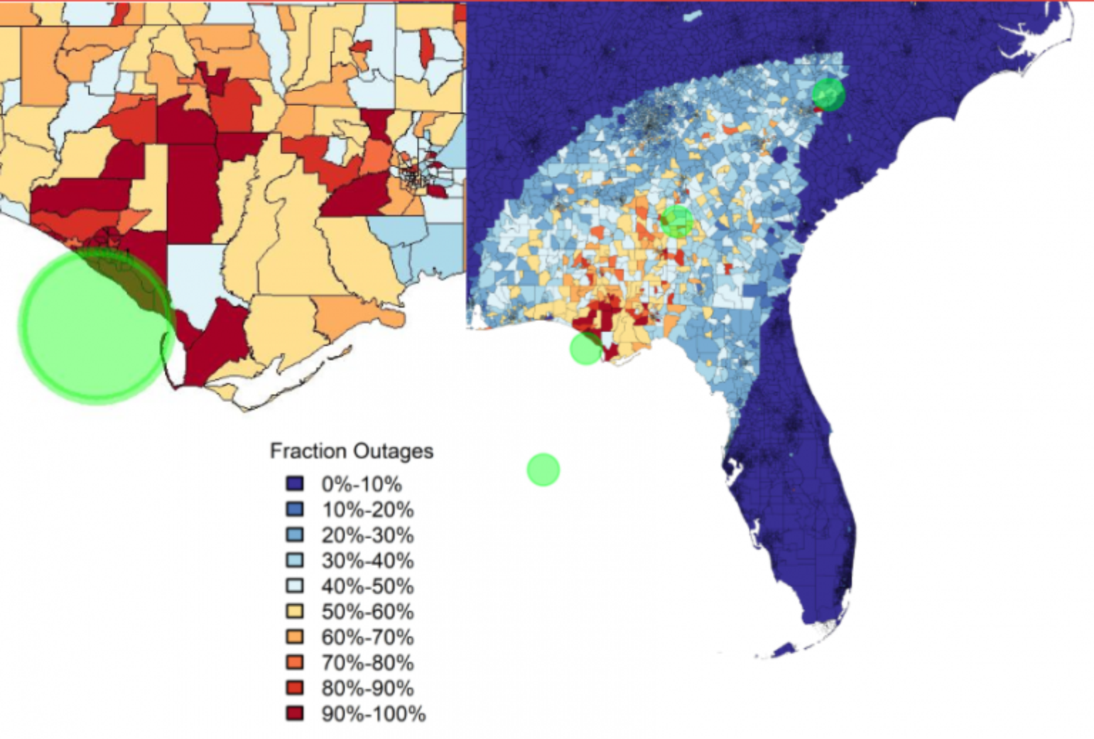
I have already touched on the likelihood of massive tree loss in the last few updates, but clearly the increased intensity at landfall confirms that treefall will lead to larger insured losses and will lengthen expected power outages. Unfortunately, this scenario is not handled well in the catastrophe models.
Michael’s strength is now at the upper end of what building codes can handle and, while Florida has the best building codes in the country, most structures were built before these codes were enacted, and retrofits have been limited.
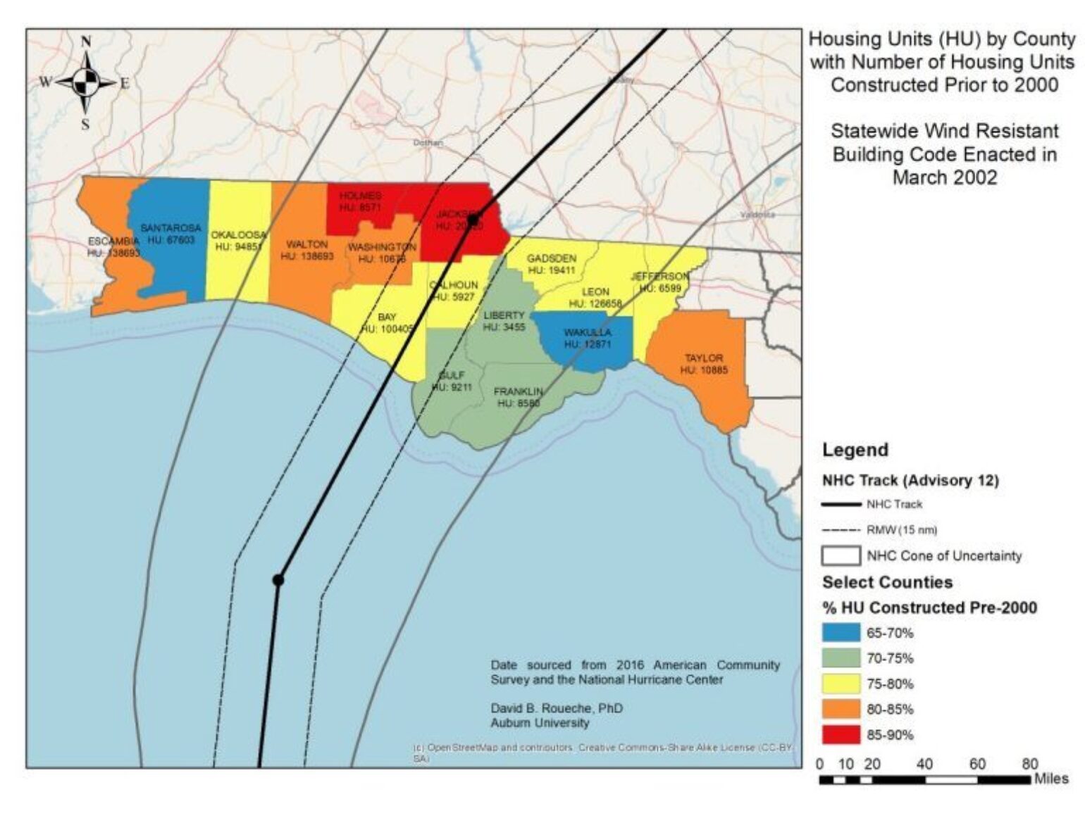
NHC currently has #Michael with max sustained wind of 145 mph. Converting to gust wind speeds over land at 10 m height gives ~150-160 mph. That's well above the 1700 year design wind speed for this region. Significant portion of FL coast could experience wind speeds above design. pic.twitter.com/1O0UpYeOON
— David B. Roueche (@auburn_windengr) October 10, 2018
Wind Swath
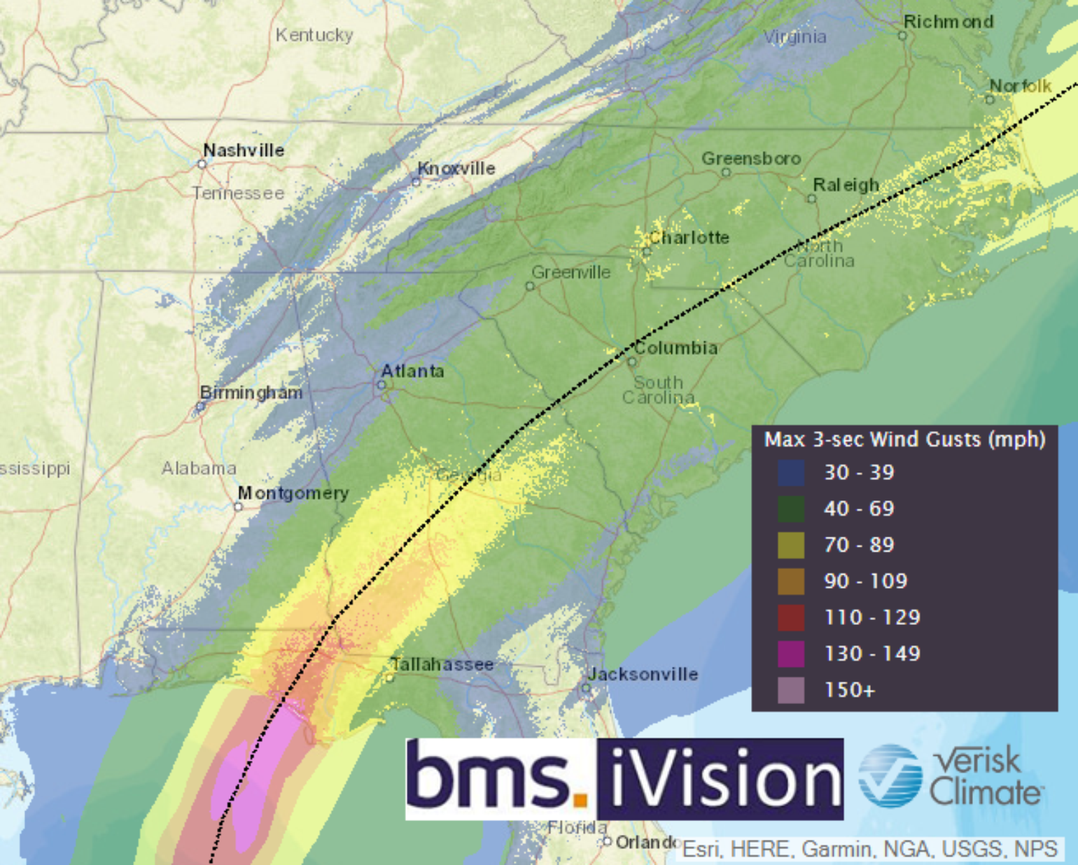
Using Verisk Weather Solutions forecasted wind swath allows BMS clients to better understand wind impact to specific risks. Currently, the wind swath suggests a radius of maximum winds to be about 26 miles wide, which is fairly tight for a hurricane. Shortly after landfall, frictional effects rapidly weaken the maximum wind speeds inland. In addition, Tallahassee should be spared any hurricane-force winds, which is a bit of better news, as insured loss will be limited in this large metro area. But, some damage and power outages could still occur.
Storm Surge
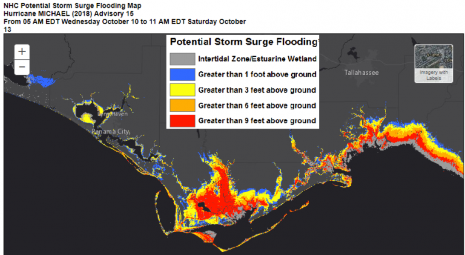
There is no doubt that record storm surge will be recorded, as storm surge values of four feet are already showing up in Apalachicola, FL. The next high tide will be just after 6:00 p.m., which should be a few hours after landfall, so, fortunately, Michael is not coming ashore during high tide.The NHC is suggesting the following storm surge levels:
- Tyndall Air Force Base, FL to Aucilla River, FL: 9 to 14 feet
- Okaloosa/Walton County Line, FL to Tyndall Air Force Base, FL: 6 to 9 feet
- Aucilla River, FL to Cedar Key, FL: 6 to 9 feet
- Cedar Key, FL to Chassahowitzka, FL: 4 to 6 feet
Rural Areas
It appears that, like some of the other devastating Category 4 hurricanes, Michael will also target an area of relatively lower population. However, Panama City has a large amount of exposure and will be the main driver of loss and, like most other U.S. coastal cities, has experienced a tremendous amount of growth over the last 30 years. Most of the other targeted areas inland remain very rural, however.
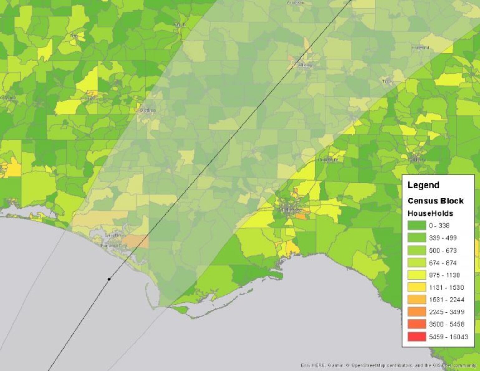
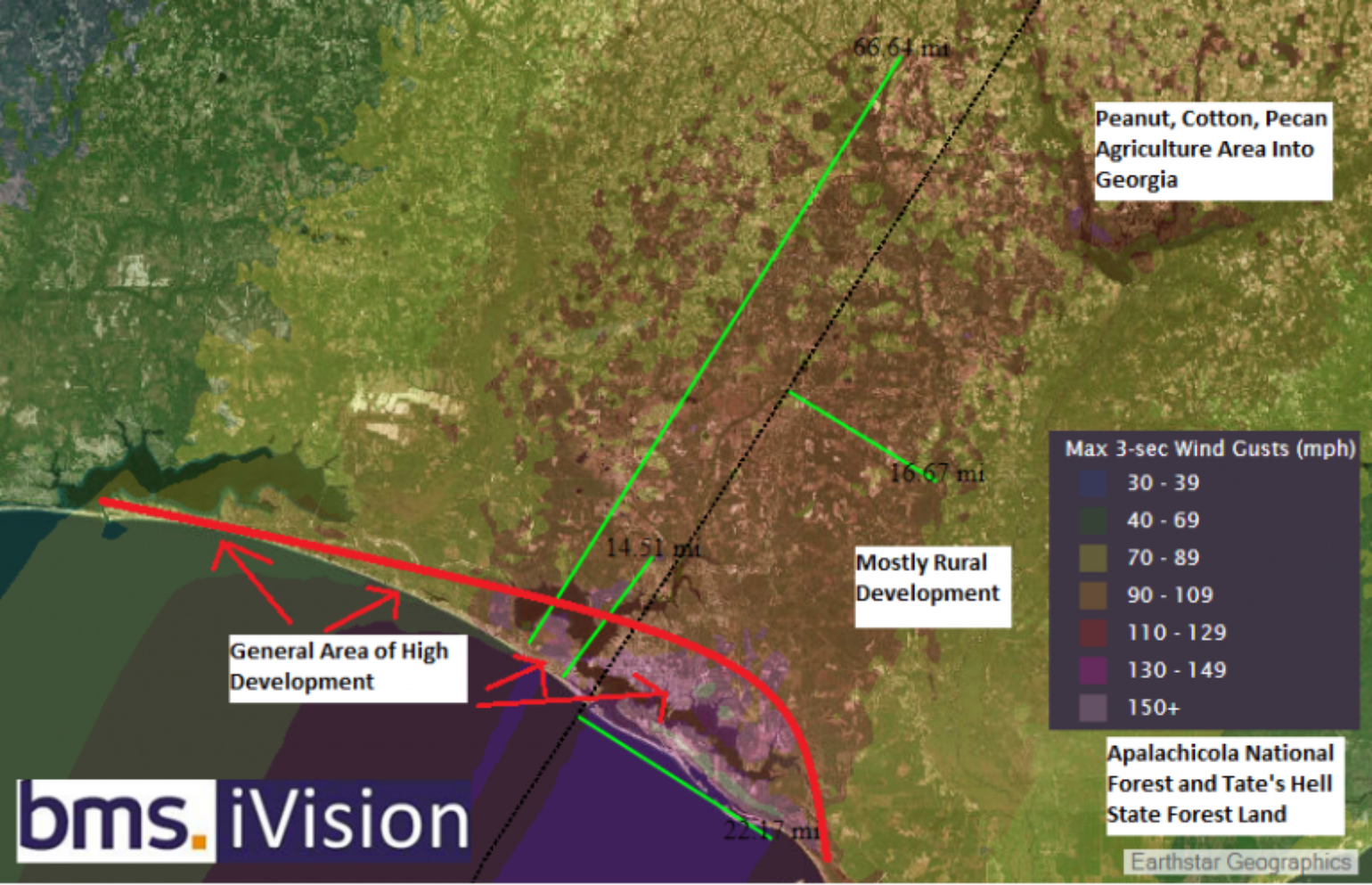
Here we take the details of the iVision wind swath with the aerial imagery applied to the base map. The radius of maximum winds is forecasted to be about 22 miles at landfall. The strongest winds are forecasted to impact the first 14 miles of coastal exposure as indicated by the first short green line, with the red line indicating areas of higher development. Most of the strongest winds will be over Forest or Agriculture land. Click on image for more detail.[/caption]The building codes inland are not as strong as in the coastal areas, such as Panama City, Fl. The older age of the homes inland, coupled with the potential for tree fall, make for uncertain loss estimates. Hurricane Irma illustrated that there are clearly loss creep issues occurring across the state, which will also add to the overall uncertainty around potential losses to the insurance industry. An early look at some of the catastrophe model guidance suggests a mid to high single-digit billion dollar loss event, but the impacts to Panama City need to be watched closely.
Never Judge a Book By Its Cover
Remember to never judge a hurricane season until it’s over and in the books. This recent uptick in activity is putting the current season back into the “above normal” category, as we now have the development of Tropical Storm Nadine in the East Atlantic, along with Leslie returning to hurricane status on its 19th day of spinning up ACE in the middle of the Atlantic. And, of course, to close out the story, we have a surprise Category 4 hurricane in the Gulf of Mexico. I think that the scientific community needs to provide more accurate seasonal forecasts and move away from the numbers game, which often leads to false impressions of a season. More attention needs to be focused instead on landfall activity. It is no longer acceptable to believe, as the old insurance industry saying goes, that it “only takes one,” since this year there has been two. Hopefully, I made this message clear at the beginning of the season. The good news is that this may be the end game for this season in terms of U.S. landfalls, as a less favorable pattern for new development takes hold across the Atlantic later next week.
