
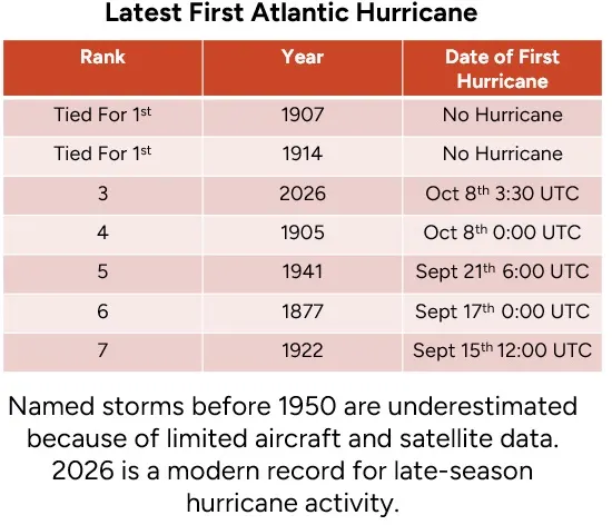
Today is Oct 8th, and it is significant because, in 1905, the first hurricane of the season formed at midnight UTC on this date. This makes it the latest season in which the first hurricane has been observed. This statistic should be taken with a grain of salt because we know two other years, 1907 and 1914, also had no hurricanes all season; however, before the 1960s, hurricanes were likely underestimated across the Atlantic Basin because of limited aircraft and satellite data. In the early 1900’s the only way to find hurricanes was on steamships. They likely tried to steer clear of nasty weather when possible, so we know that there could have been hurricanes earlier in the season in those years, which highlights how remarkably quiet this Atlantic hurricane season has been to go this late into the season without a hurricane, given our modern hurricane records and observation systems.
With Isaias upgraded to a hurricane at 03:30 UTC on Oct 8th, it becomes the latest hurricane to form in the long Atlantic Basin record. This formation also means every year since 2016, except last year, has had a Gulf hurricane. So it's been a remarkably active period for hurricanes in the Gulf over the last decade, and this year is no different, with almost all the named storm and hurricane activity being in the Gulf.
Summary: Hurricane Isaias has been steadily strengthening in the Gulf over the last 36 hours. It will turn north and race toward the Gulf coast between Pascagoula, AL, and Destin, FL, and make landfall Friday night. The big question is how fast it weakens before landfall, as dry air and wind shear along the Gulf Coast will likely weaken it. This weakening also means Isaias's impacts will be heavily weighted to the right side of the storm track, with limited impacts to the left side. Because of its fast forward speed at landfall, a 20 mph, storm surge should not be a major issue. This will also limit heavy rain and flooding, but fast-moving tornado chances across the Southeast are increasing as it races inland.
Wind Shear Rules
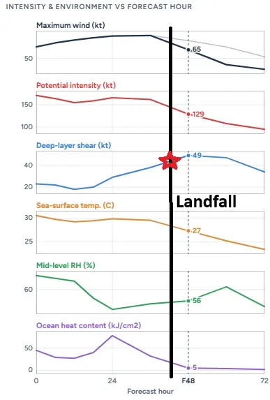
Wind shear is one of the main reasons this Atlantic Season has been historically quiet, so it's no surprise that Isaias has spent the last couple of days trying to get organized. One reason there hasn't been extreme rapid intensification yet is that wind shear is impacting the storm's western flank, and while wind shear will weaken a bit, this will allow more intensification today. Wind shear will be very strong along the Gulf Coast and will ultimately lead to rapid weakening before landfall.
Isaias's strength at landfall depends on how strong it becomes today. The stronger it becomes today, the more it will have to weaken before landfall, when it hits hostile conditions of dry air and higher wind shear. A stronger Category 2 or 3 hurricane later today/tonight means a stronger Category 1 hurricane at landfall. A run-of-the-mill Category 1 hurricane today could mean a stronger tropical storm at landfall.
Friday, we’ll see Isaias likely get hammered by wind shear that worsens throughout the day on Friday as it approaches landfall in the evening. Below is the SHIPS model showing wind shear. Marked is the intensity dispersion right at or immediately before landfall. It shows that at 36 hours, wind shear will be 38 kts, and at landfall, wind shear will be close to 50 kts, which are very hostile conditions to maintain a vertically stacked hurricane. Overall, Isaias's intensity will depend on how strong it becomes today and how much wind shear it encounters before landfall, which will lead to weakening.
Wind Impacts
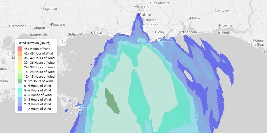
As mentioned, Isaias's strength today will determine its overall intensity at landfall, as wind shear rapidly weakens the circulation center. However, dry-air entrapment will also weaken the circulation while expanding the wind field as the storm system takes on extratropical characteristics. Below is our BMS iVision, powered by EigenPrism, showing the Verisk Respond 3-second wind swath.
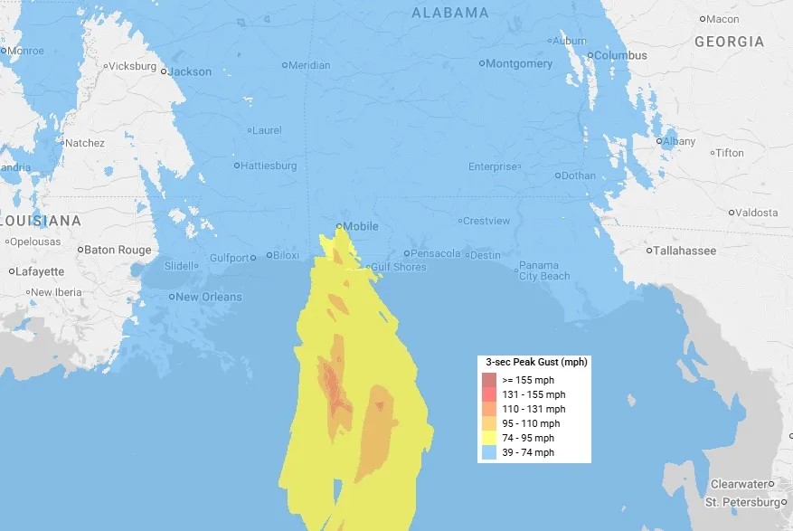
The wind swath shows hurricane-force wind gusts impacting Dauphin Island, Gulf Shores, and Orange Beach, but note that the location of these maximum winds could shift left or right depending on the landfall location; this should give the insurance industry an idea of the general width of the strongest winds expected, with a much wider extent to the right side of the storm of tropical-storm-force wind gusts.
As mentioned, a hurricane has formed in the Gulf every year since 2016, except last year. The area has had plenty of storms to deal with recently: Sally (2020), Nate (2017), and Ivan (2004) all made landfall around Mobile, AL, but over time, we've also made huge progress in building hurricane resiliency. Alabama is home to over 53,000 certified fortified homes, making it the state with the most fortified homes in the nation. This is just a small number of the overall homes along the coastline. Still, it’s a move in the right direction, and given the recent activity, any recent damage has hopefully been repaired to a higher standard. Expected winds will be well below any speed that should cause severe structural damage, thanks to stricter building codes along the Gulf Coast. This should be reflected in overall insurance losses and the number of claims.
Storm Surge Impacts
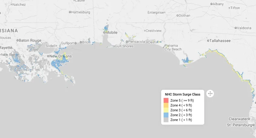
Because Isaias will move rapidly toward the Gulf Coast at 20 mph, it won’t have time to pile up a large amount of water along the coastline. Large Gulf Coast storm surge events occur from large, slow-moving hurricanes. Isaias will not be the case. This doesn’t mean there won’t be storm surge impacts; it means newer buildings that comply with current high-water building requirements should be fine during this storm surge event.
Peak storm surge levels could reach 5 to 7 feet above ground near and east of Isaias's landfall.
Flooding Impacts
The rainfall data below show the ground is saturated from recent heavy rains, but given the fast-forward speed, heavy precipitation will be limited at Isaias's landfall.
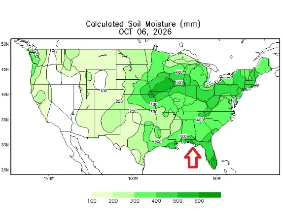
Some areas east of the center could still see 3 to 6 inches of rain, but the flash-flooding threat and inland extent of flooding we saw with past Gulf landfalling storms like Ida (2020) and Helene (2024) won’t be noteworthy with Isaias. The saturated soil, however, could increase treefall as root systems weaken under stronger wind gusts, but overall, with Isaias moving, strong wind gusts will be fairly short-lived.
Severe Weather Impacts
One thing becoming a little more concerning with respect to Isaias is severe weather. As Isaias moves northward, it will spread rain and thunderstorms over a wide area of the Southeast. Due to increased upper-level wind shear at landfall, multiple individual supercell thunderstorms could support rotating storms. Storms that are typically going through extratropical transition can produce meaningful tornado outbreaks, like Beryl and Milton during the 2024 hurricane season.
Insurance Industry Impacts
The landfall location, intensity, and overall structure of Isaias remain uncertain, but based on what we know, historical analogs like Hurricane Sally (2020), and catastrophe model runs, this would likely be a low single-digit billion-dollar loss for the insurance industry, with a range of $3B to $ 5B, with 80% of Category 1 events impacting the Mobile region resulting in losses below $3B of industry loss. Isaias will no doubt add to existing losses along the Gulf Coast in what is, overall, a historically low year for hurricane activity across the Atlantic Basin. For now, it does not seem this will materially affect current capacity or the softer market conditions in the U.S. property insurance market.