
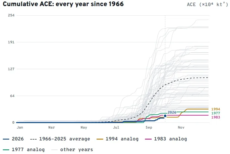
Hurricane Isaias is on track to accumulate well over three-fourths of the season's total Accumulated Cyclone Energy (ACE) year-to-date. The season total before Isaias was 10.78, and Isaias will likely contribute more than 8 units before it dissipates over the Southeast U.S. This matters because it will likely push seasonal ACE above the historically low year of 1983, which ended with 17.4 units of ACE. Of course, the season isn’t done yet, and the Atlantic Basin will likely see a few more storms before December 31st. So, this won’t be the quietest hurricane season on record.
Summary
Hurricane Isaias is now a Major Category 3 storm this morning and could strengthen further in the next few hours. This was a major puzzle piece to the expected landfall intensity. The stronger Isaias becomes over the warm Gulf waters, the longer it will take to weaken after landfall. Landfall is now expected to occur between 7 p.m. and 10 p.m., earlier than previously forecast. ,This leaves less time for weakening, increasing the likelihood of a stronger storm at landfall, likely near Pensacola, FL. Most insurance impacts are expected on the storm's right side, relative to its direction of travel. Insurance losses have increased slightly since yesterday because it's impacting a more populated area with more exposure, and it's stronger than many of yesterday's scenarios, which focused on Mobile Bay.
Intensity vs Dry Air and Wind Shear
By now, the insurance industry should know that a hurricane isn’t necessarily a landfall point with a specific category. They can take many forms and have impacts that extend well beyond the initial landfall point and the NHC-given intensity. With Isaias, some meteorological factors complicate how much it will weaken today before landfall tonight. In yesterday's tropical update, much of the focus was on how dry air and wind shear could affect Isaias's landfall intensity. Because Isaias was traversing a warm, deep area of high ocean heat content, it would take much longer for dry air and wind shear to weaken the system before landfall. Isaias is now expected to remain much stronger than previously forecast, meaning a stronger hurricane at landfall.
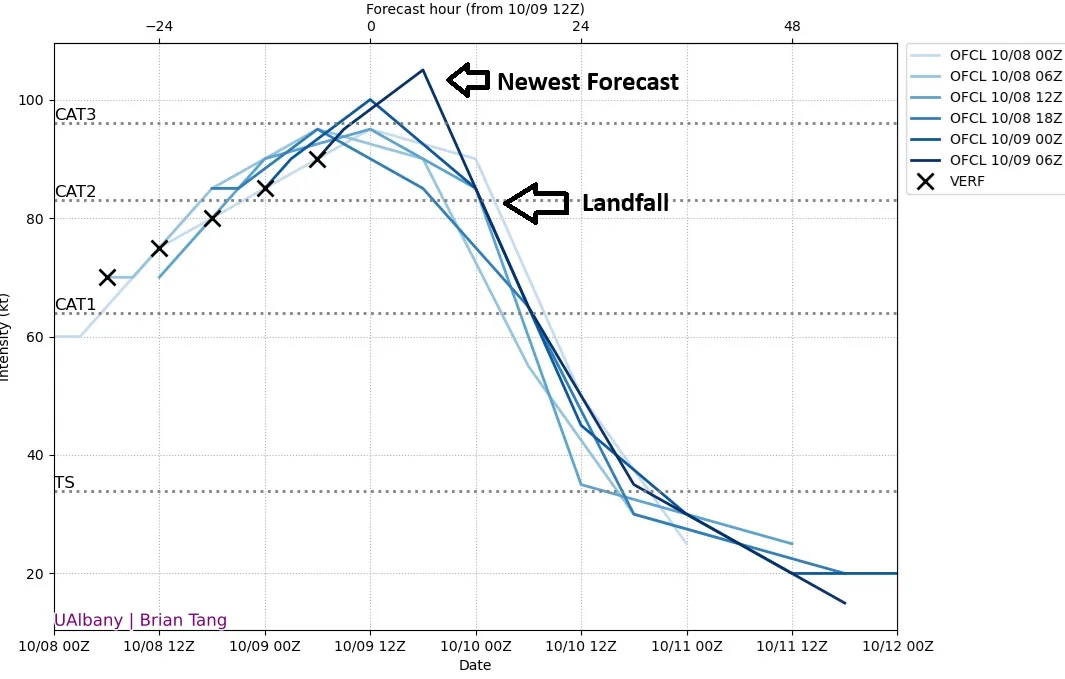
The image above from the University of Albany shows the last six NHC official intensity forecasts; you will notice the darkest blue line is the newest and has the highest intensity, peaking later before it declines. When you combine this with a projected earlier landfall time tonight, maybe as early as 6 p.m. compared to 10 p.m. to 1 a.m. yesterday, the dry air and wind shear will have less time to weaken Isaias from its peak intensity later today. As it weakens, however, Isaias could start to transition to a frontal/extratropical low. This means maximum winds will likely decline while the radius of tropical-storm-force winds expands, especially north and east of the center. Don’t be surprised if it looks strange on radar and satellite imagery before landfall. Don’t expect Isaias to look like a classic hurricane as it does right now. After landfall, Isaias will quickly become post-tropical as it merges with an upper-level low over Mississippi and Alabama. The remnants of Isaias will continue up the Mississippi and Ohio River Valley on Sunday, then hook east through the Mid-Atlantic on Monday.
Isaias should weaken at landfall, which is much better than if it were strengthening. Isaias will have a small, tight center of circulation. The radius of maximum winds extends only 7 to 10 miles from the center, with hurricane-force winds extending only 30 miles. Tropical storm-force winds extend out to 185 miles. While it is not expected that the inner core of the hurricane changes much with an eyewall replacement cycle due to dry air and wind shear already impacting Isaias, it is this extent of the tropical storm-force winds that will greatly expand, especially to the east later today, which will have a larger effect on insurance-related losses. Because the storm's core is smaller, with an almost pinhole eye and less energy, dry air and wind shear could more easily disrupt it. This is why timing and speed to landfall are so critical to predicting landfall intensity. However, hurricane-specific models are trending toward a slower extratropical transition for Isaias today, with the core potentially remaining intact closer to the coast. This means stronger winds near landfall.
Wind Impacts
Based on the latest BMS iVision Powered by EigenPrism Verisk Respond wind swath, the strongest likelihood of peak wind gusts in the 80 to 95 mph range is in southern Alabama and the western Panhandle tonight, especially on the coast between roughly Dauphin Island and just east of Destin.
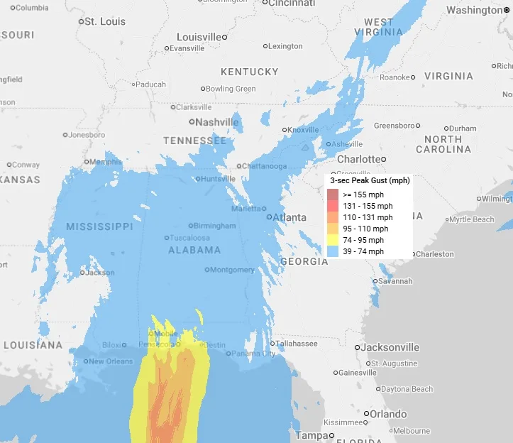
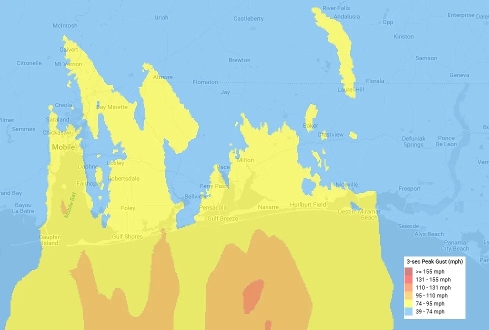
Unlike parts of the East Coast that are in a hurricane landfall drought, this section of the Gulf Coast is no stranger to hurricane landfalls. As discussed yesterday, recent landfalls in the area, like Hurricane Sally (2020) and the even stronger Ivan (2004), have created plenty of opportunities to build back better. The strongest wind gusts will impact a fairly dense built-up part of the coastline, and if the military didn't own a large area, it would likely be even more built up. Overall, homes in the Pensacola area are older, and the trees are older than in newer, popular beach communities nearby that have boomed in recent decades. Because of this diversity in the housing stock, the exact location of the strongest winds is critical to damage.
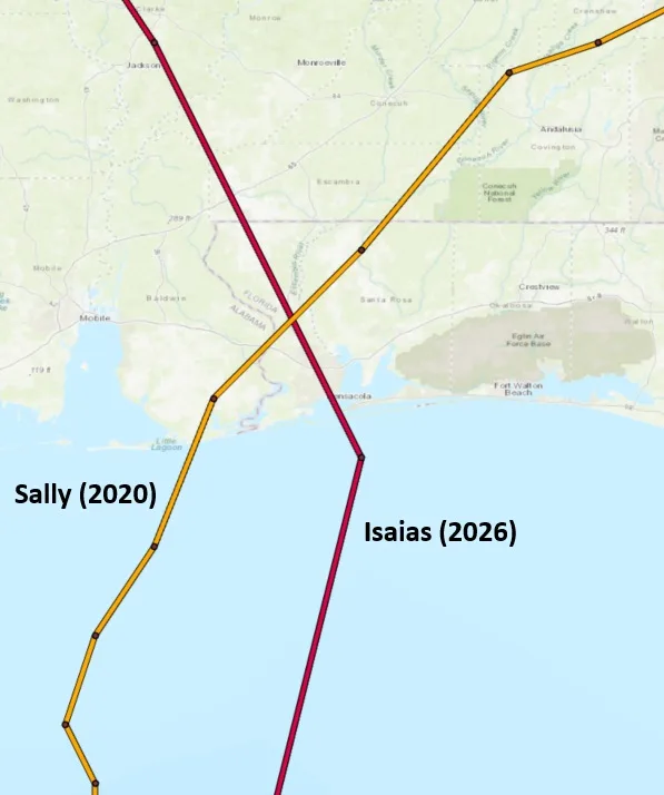
Isaias will make landfall very close to where Sally did as a Category 2 hurricane in 2020, making it an excellent analog for Isaias's impacts. Sally had a radius of maximum winds of 20 miles, hurricane-force winds out to 40 miles, and tropical storm-force winds extending 125 miles. This could be very similar to Isaias’s landfall. The pressure might also be similar at 965 mb. The overall adjusted insurance loss for Sally is just over $4B to the insurance industry. Ivan (2004) also made landfall just west of Pensacola as a Category 3 with a pressure of 946 mb and a much larger footprint and more inland impact; adjusted insurance industry losses were $12B. This shows that overall intensity and footprint size can make a large difference in insurance losses.
Storm Surge Impacts
As mentioned above, hurricane impacts aren't just about landfall location and intensity. Storm surge is a good example of how impacts can extend far beyond landfall. The good news for storm surge impacts, as stated above, is the direct correlation to Isaias's size, which is relatively small and will move very fast at landfall (20 mph). This will limit overall storm surge compared to a slower-moving, stronger hurricane. While winds may weaken rapidly toward landfall, the ocean has more memory, so storm surge impacts from Isaias won’t be very sensitive to any possible reduction in maximum winds in the last few hours before landfall. The greatest storm surge will be east of the landfall range; roughly from AL/FL Border to Indian Pass, FL. These areas are likely to see 5 to 7 feet of storm surge; an unfavorable high-tide timing on Friday night between 10 p.m. and midnight could exacerbate it. This is why landfall timing matters, too. A later landfall time means even higher water levels than an earlier landfall.
Once again, Sally (2020) is a good analog because of its similar size and intensity; it produced a 5.6’ high water mark in the Pensacola area, the third-highest event in the last 100 years. Of course, storm surge depends on highly localized geography, so pay attention to the NHC storm surge product below, which is also available in our BMS iVision product.
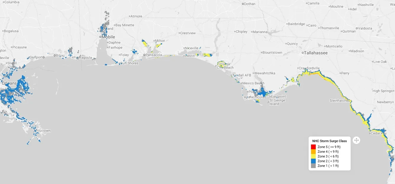
Further east into Apalachee Bay, expect maximum storm tides of 3’ to locally as much as 6’ from Apalachicola to Cedar Key as a long fetch of stiff onshore winds drives trapped water into the shallow bays of the northeast Gulf.
Tornado Impact
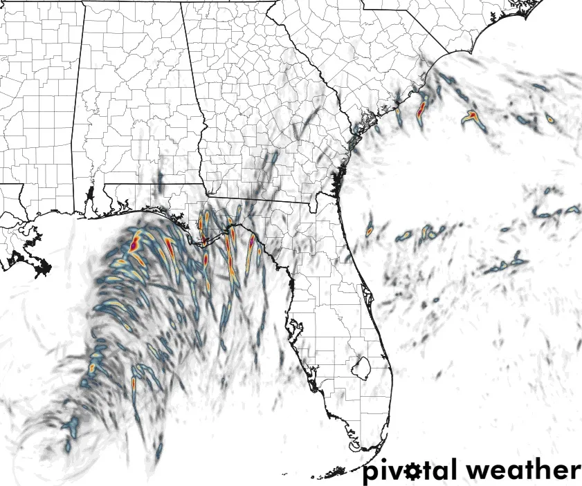
Overall, flood and rainfall look manageable for Isaias, but as noted yesterday, saturated ground and older trees around Pensacola, FL will be more susceptible to tree fall. However, with the fast landfall speed, heavy rains will be short-lived over much of the region. These fast-moving supercells within the main circulation center also create other severe weather threats for the Southeast as Isaias moves inland. The extreme westerly wind shear Isaias will encounter Friday evening will weaken the hurricane. Still, it creates a very favorable environment for tornadoes to develop in the outer bands of the storm's eastern half. This threat will linger into Saturday in the Florida Panhandle and also extend well inland across the Deep South.
Below is the HRRR model showing helicity, or the rotation of the atmosphere, as it relates to possible tornado formation. This could produce some fast-moving tornadoes. These tornadoes tend to be shorter-lived and weaker, but as Milton (2024) experienced, some can be long-tracking and stronger than EF1.
The storm prediction center (SPC) considered adding a more substantial tornado intensity risk contour to their outlook. This leaves a chance they could upgrade this risk later today.
Insurance Loss Estimates
As stated yesterday, the landfall location, intensity, and overall structure of Isaias remain uncertain even with landfall about 12 hours away. Still, based on what we know, historical analogs like Hurricane Sally (2020), and catastrophe model runs, the losses today should be higher. This is simply because the expected landfall location is farther east, with a stronger storm near Pensacola, FL. Losses should be below $10B, with an expected range of $4B to $6B today. However, as shown in the loss difference between Sally (2020) and Ivan (2004), there can be exponentially higher losses with a stronger storm, which is why how strong Isaias gets today and how fast it moves forward, will determine how much time it has to weaken before landfall due to drier air and wind shear. In leading catastrophe risk model event sets, 80% of Category 1 events impacting the Pensacola, FL region result in industry losses below $3B, but when adjusted to Category 2 events, losses jump to $17B. So, losses are quite sensitive to overall landfall intensity, and while insurance industry losses for Isaias increased, this still does not seem to materially affect current capacity or the softer market conditions in the U.S. property insurance market.